

April 2019 Discussion with WeatherTrends360

It’s time to harness WeatherTrends360 technology and look at how April 2019 should play out. WeatherTrends360 algorithms are documented with an 84% verification rate and are based on oceanic water cycles, time table series and very complex mathematics. The best takeaway from this data are general trends (cool vs warm, rainy vs dry, etc). I’m always hesitant to forecast specific surface conditions (rainfall amounts, snowfall amounts, winds, etc) beyond the 7 -day forecasting period. But temperature and precipitation trends are what WeatherTrends360 does best with their proprietary mathematical analysis derived from over 150 years of reactive pattern data. For this reason, let’s call this a long-range discussion of expectations rather than a locked-in long-range forecast.

The following diagram is calculated for the meat and potatoes of New Jersey in general. Please keep in mind that micro-climate influences can vary. NWNJ elevations and immediate coastal areas, for example, will likely verify slightly cooler than illustrated. Interior CNJ/SNJ slightly warmer than illustrated. But for most of New Jersey this diagram should suffice for the general idea of temperature and precipitation trend analysis.
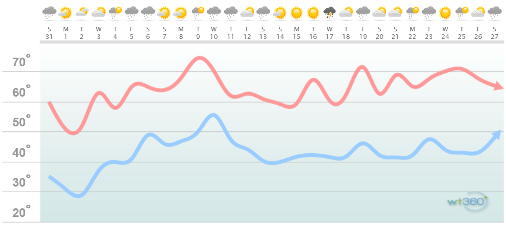
Discussion: The last of the colder early-spring troughs will dominate the pattern to start this week. The current cold front is moving through today (March 31) to usher in the colder air mass. The coldest conditions should occur early Monday and Tuesday (April 1 and 2) mornings. The coastal disturbance will be out there Tuesday evening but likely with little-to-no impact. A SENJ graze of N/NE winds with some rain at most and during Tuesday-Wednesday overnight hours. OBX and Cape Cod will likely see higher impacts. From Wednesday-forward we begin to moderate with milder temps for the weekend and start of next week. Expect a moderation back to cooler temps after the April 5-9 mild period but not as cold as how April started (early this week). The second half of April continues the overall trend upward in temperature but with a few spikes and dips associated with an expected active pattern. Rainfall appears adequately scattered throughout the month mostly in the form of normal spring showers/t-storms not higher-impact synoptic storm systems.
In English: April 2019 should end warmer than it starts per tradition. We’ll likely see the coldest conditions of the month overnight tonight through tomorrow into Tuesday morning. Then we moderate from Wednesday-forward. The rest of the month should feature near-average temperatures with average to slightly-above average precipitation. It’s spring shower and t-storm time once we turn the corner later this week. Next week appears to be anomalously warm compared to the entire general upward temperature trend. No major storm signals are on the horizon but I’ll capture them within the 7 day forecasting period should they arise. Everyone have a great April and please be safe! JC

Jonathan Carr (JC) is the founder and sole operator of Weather NJ, New Jersey’s largest independent weather reporting agency. Since 2010, Jonathan has provided weather safety discussion and forecasting services for New Jersey and surrounding areas through the web and social media. Originally branded as Severe NJ Weather (before 2014), Weather NJ is proud to bring you accurate and responsible forecast discussion ahead of high-stakes weather scenarios that impact this great garden state of ours. All Weather. All New Jersey.™ Be safe! JC


LOCAL FORECAST | INTERACTIVE RADAR | LATEST NJ WEATHER ALERTS | WEDDING FORECAST| PRIVACY POLICY
© Copyright 2025 Weather NJ LLC. All Rights Reserved.
Some information that can be found on our website is provided by a private weather station and is not an officially recognized station for weather reporting. Though we always strive to achieve accurate reporting for our own use, it is important that you do NOT depend on the data provided here for any purpose.
