

April 21: Wednesday Rain and Thunderstorms Expected!
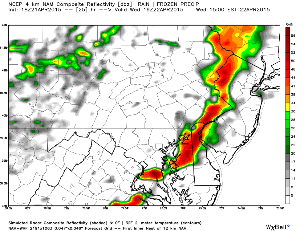
Low pressure in Canada will track from just north of the Great Lakes eastward—dragging a cold front beneath it through New Jersey on Wednesday. This should at least bring rain showers through the region but possibly thunderstorms as well. The short-range high-resolution NAM has been pretty insistent on a line of rain and thunderstorms passing through the region Wednesday afternoon. We’re looking at very marginal instability but decent wind shear (similar to last night). Here are simulated radar slides off the 18Z NAM:
Rainfall intensity between 2-3PM on Wednesday
Rainfall intensity between 3-4PM on Wednesday
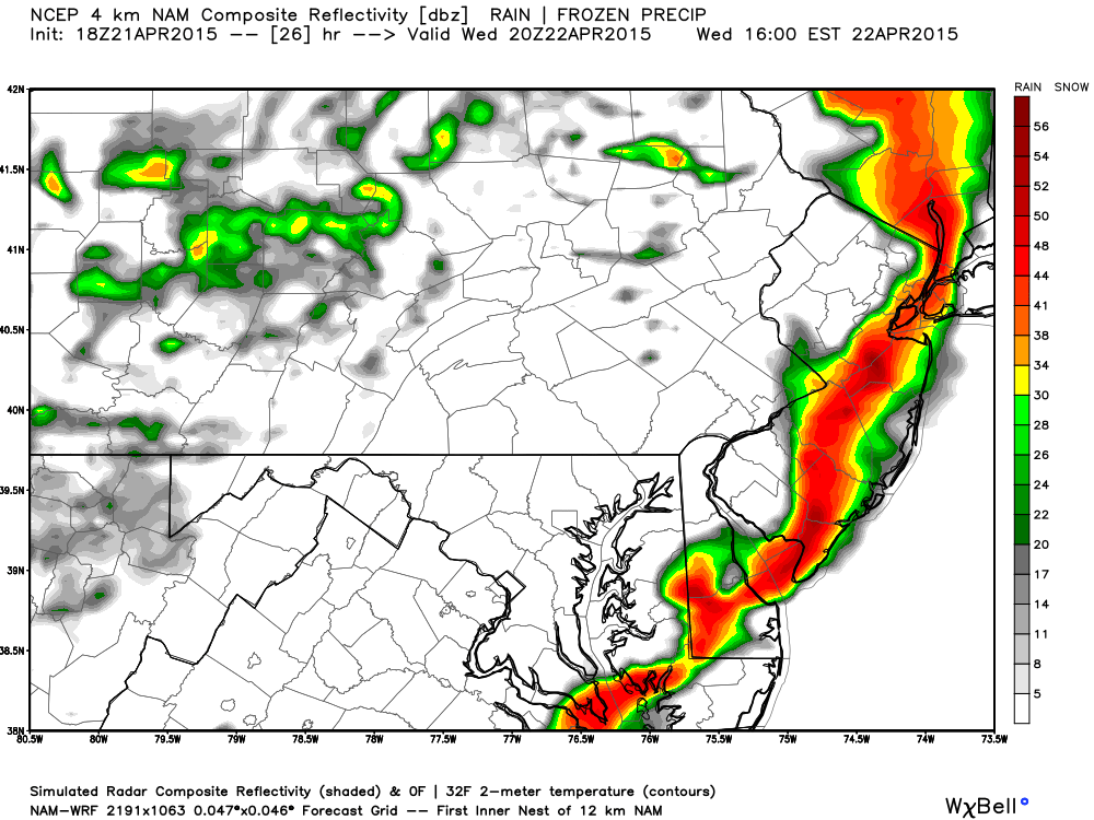
The simulated radar returns indicate precipitation rates of 40dbz or greater (heavy downpours). This is a convective signature capable of producing severe thunderstorms should wind gusts exceed 58mph and/or 1-inch or larger hail occurs. These heavy showers and thunderstorms would be short-lived due to the speed of the passing line segment. The cold front will be blowing through afterwards which will clear the storms out pretty fast. We should see the sun again before it sets.
In English: Expect a short period of rain and thunderstorms tomorrow afternoon. They should span the entire state from NW to SE between noon and 4PM. Expect a breezy and gusty but mostly dry evening afterwards. Only isolated remnant showers will linger behind the storms until midnight.
Check out our friends at Mid-Atlantic Waterproofing—serving all of New Jersey and the general Mid-Atlantic US with waterproofing, foundation repair and basement dry-out services. With a rainy spring anticipated, it’s probably not a bad idea to schedule a FREE foundation inspection. Be safe! JC
Jonathan Carr (JC) is the founder and sole operator of Weather NJ, New Jersey’s largest independent weather reporting agency. Since 2010, Jonathan has provided weather safety discussion and forecasting services for New Jersey and surrounding areas through the web and social media. Originally branded as Severe NJ Weather (before 2014), Weather NJ is proud to bring you accurate and responsible forecast discussion ahead of high-stakes weather scenarios that impact this great garden state of ours. All Weather. All New Jersey.™ Be safe! JC


LOCAL FORECAST | INTERACTIVE RADAR | LATEST NJ WEATHER ALERTS | WEDDING FORECAST| PRIVACY POLICY
© Copyright 2026 Weather NJ LLC. All Rights Reserved.
Some information that can be found on our website is provided by a private weather station and is not an officially recognized station for weather reporting. Though we always strive to achieve accurate reporting for our own use, it is important that you do NOT depend on the data provided here for any purpose.
