

April 4: Thunderstorms Today. Snow this Weekend.
Discussion: Temperatures are spiking SE of the I-95 corridor. Some SNJ locations have already broke 70F. Temperatures along and NW of I-95 however remain generally in the 40s. The difference? Cloud cover. The sun is making it to the surface for the warmer areas and destabilizing the lower-levels via diurnal heating. The cooler areas are under cloud cover and are therefore under more stable air.
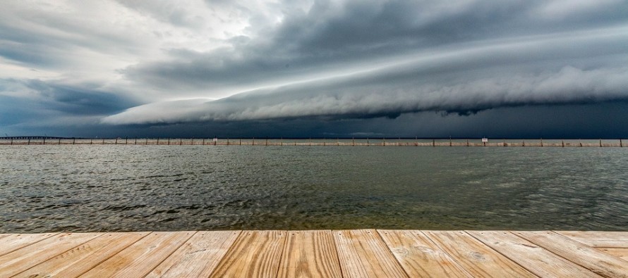
A line of convection is approaching from the W (currently in EPA) along and ahead of a cold front. I’m guessing that the warmer areas (SNJ) are going to see more frequent lightning and heavier rainfall than the cooler areas (NNJ). But everyone is on the hook for linear precipitation passing from W to E over the next 3-4 hours or so.
Everyone is also on the hook for high winds. Strong and gusty S/SW winds should transition to strong and gusty W/NW winds behind the cold front. That’s how you’ll know the front is through. The National Weather Service will issue Severe Thunderstorm Warnings for any areas that meet the criteria for wind and/or hail (58mph+/1 inch or greater). Again I think SNJ has a better chance of that than NNJ.
I’m still monitoring the snowfall potential this weekend. A first weaker wave could pass through the region on Friday in the form of a warm front with a snow/rain line likely in the NNJ elevations. Very little precipitation though and most precipitation falls during daylight hours. Not really concerned about it other than some wet roads. A lull is then expected Friday night before the main event arrives for Saturday morning-afternoon. While a decent amount of snowfall has been consistently modeled, it is going to be very hard for snow to stick during the day on Saturday due to solar radiation. We might be looking at an epic white rain event. White rain is when snow falls and melts on street contact. So I think the snowfall is very possible but travel disruption should be inhibited and mostly limited to wet (possibly slushy) roads. SNJ is currently favored over NNJ for the heaviest snowfall. Let’s see where the data and live observations are tomorrow. There is always the micro-chance of super heavy snow bands developing that could cool the SNJ surface to the point of stickage. These would be unicorn April weather conditions but given how this back-loaded winter is performing, why not?
In English: Expect a brief period of rainfall, possibly heavy, between now and early afternoon. Expect gusty, possibly damaging, winds rocking from S/SE to W/NW as the cold front moves through. The W/NW winds should sustain overnight tonight and usher in a colder air mass. Lightning is possible today, especially for CNJ/SNJ areas currently under bright sunshine with spiking temperatures. Cooler areas in NNJ will likely see less thunderstorm activity but still the rain and wind. This is all moving from W to E so the coast should start and end last. WNJ is just about to start and will end first. We should then turn chilly tonight heading into the weekend. Snowfall is possible on Saturday but I just don’t see cause for alarm yet. The snowfall is expected to fall during peak solar radiation daytime and we’re getting pretty far into spring now. Also the area of heaviest snowfall is targeting SNJ which would have the strongest marine/warming influence in the state. It could happen but it would take thread-the-needle unicorn physics for snow to stack up during the daytime this Saturday. I’ll continue to monitor but we might just be looking at a period of mostly white rain with minimal disruption. Have a great rest of your Wednesday and please be safe! JC
For comprehensive and interactive hyper-local analysis that goes way above and beyond the detail of this public forecast, check out our premium services which include early hyper-local text notifications and guaranteed individual forum interaction. A must for outdoor businesses that depend on the best real-time data possible.
Jonathan Carr (JC) is the founder and sole operator of Weather NJ, New Jersey’s largest independent weather reporting agency. Since 2010, Jonathan has provided weather safety discussion and forecasting services for New Jersey and surrounding areas through the web and social media. Originally branded as Severe NJ Weather (before 2014), Weather NJ is proud to bring you accurate and responsible forecast discussion ahead of high-stakes weather scenarios that impact this great garden state of ours. All Weather. All New Jersey.™ Be safe! JC


LOCAL FORECAST | INTERACTIVE RADAR | LATEST NJ WEATHER ALERTS | WEDDING FORECAST| PRIVACY POLICY
© Copyright 2026 Weather NJ LLC. All Rights Reserved.
Some information that can be found on our website is provided by a private weather station and is not an officially recognized station for weather reporting. Though we always strive to achieve accurate reporting for our own use, it is important that you do NOT depend on the data provided here for any purpose.
