

Arctic Nor’easter New Jersey Impact Map
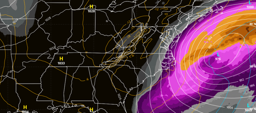
Discussion: The trend out to sea on model guidance continues. At the upper levels, the trough is now modeled with too positive of an axis to allow a storm to bring snow W more than 10-20 miles away from the coast at most or any further N than about I-80 latitude at most. The upper low cuts off too far to the S with suboptimal phase timing to tilt the trough enough. At the surface this translates to an immediate coastal graze or nothing on most model output.
So we’re in a spot that I hate to be in as a forecaster. This low is very powerful, likely a sub-980 central pressure. Additionally, there are two of them now. It’s not bad enough that we have a swinging trough, phase timing, and low capture involved. Now we have to deal with multiple strong coastal lows behaving in almost a Fujiwara effect. I look at this setup and just do not trust that this is how it’s going to play out 72 hours from now. The way I feel, and I know a lot of you are here for my gut feel, is that given the intense dynamics of what’s going to be out in the ocean, it’s a black and white situation and I have to make a gray forecast. Black and white as in hit harder or miss completely. Why the term gray forecast? When making a forecast you have to present an evidence-based call. And there is little data evidence to suggest anything more than light snow showers possibly grazing SENJ. While the track is locking in, we still don’t know how large the precip shield will be on the N and W side of the storm. Now we are talking about possibly 40 miles W or E could mean the difference between a foot of snow or nothing should something like the Euro Ensemble mean verify. 40 miles to a storm with a 1500-mile total storm precip diameter is really nothing at all. It can easily happen if subsidence (sinking air) were to form slightly offshore which then in-turn enhances lifting on the outer fringe of the precipitation shield. It could easily happen with a micro deviation of low track and timing. There’s data-driven evidence and then there’s past experience to consider in addition to drastic changes still possible from this range. But a gray forecast ranging from minimal snow showers to nothing at all just doesn’t sit well with me. I feel like I am telling someone that they will likely sustain light injury from a lightning bolt strike when in reality it will most likely either end them or spare them unscathed because they were grounded or something. But here we are.
So, the evidence-based snow forecast is going to be non-aggressive for SENJ and the immediate coast. However, we should stay vigilant should any surprises rear their head in the next 72 hours (48 hour leading up to the storm – through Saturday night – and 24 hours when the storm is closest to NJ – Saturday night through Sunday night).
The coastal flooding situation is a more confident prediction at this point. The Stevens Flood Advisory System indicates the high-end of minor to low-end of moderate stage coastal flooding up and down the coast from Monmouth to Cape May. This includes ocean facing coasts, inlets, back bays and estuaries. There will be some water level rise in Delaware Bay, especially with the near-full moon but not to the extent of the wind-driven surge-exposed ocean-facing coasts. The unique challenge here will be lots of frozen bay water rising with the tide. This could wreak havoc on docks and bulkheading when ice frozen to the docks and pilings rises with the above-normal tide. This could also wreak havoc once bay water returns back to the ocean though drainage but leaves wet surfaces (roads that normally flood) exposed to the Arctic air to freeze. Lastly, there should be some wild ocean spray freeze formations from cold + wind. This can affect many structures including power lines. Immediate coastal areas should consider if anything can be done to mitigate these potential outcomes. All issues are unique because of the cold temperatures (below 20F) and existing bay ice. Most coastal flooding typically occurs in an above freezing environment which we will not have this weekend.
Though we haven’t put any numbers out yet, we’re going to downscale possible snow expectations with regard to what the models have been showing in prior days, even for SENJ. But we’re going to stay vigilant should the precipitation shield evolve differently than the following evidence-based graphic. Must acknowledge what the models are showing now. But must also expect more changes, even surprises, given the multiple surface low solution now modeled.
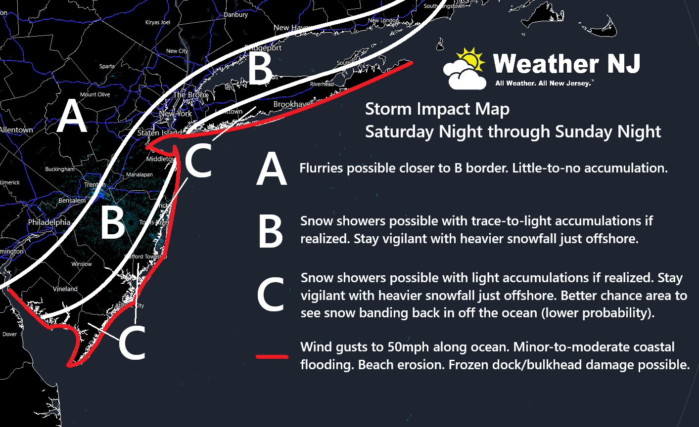
In English: The most reasonable expectation for Saturday night through most of Sunday are anything from a graze of snow showers to nothing at all. Given how intense the storm will be out in the ocean, there are certainly concerns for changes over the next few days and even surprises through the 11th hour. Although there is no numerical computer data guidance to suggest such, I recommend staying vigilant should SENJ, especially the SENJ coast, get into some harder snow. Otherwise, the above graphic illustrates a very middle of the road, gray, approach in a black and white situation (harder hit vs miss). I could see winds gusting to 50mph along the immediate beach coast and maybe 30-40mph away from the ocean phasing out to even less the further W and N you get away from the ocean in NJ. Minor-to-moderate coastal flooding is likely, especially during the ~8am Sunday high tide and ~8pm evening high tides. Add the element of frozen bay tops and you’re looking at marine dock/bulkheading damage. If water comes into the streets and then retreats, some of that will likely freeze before evaporating. Some unique coastal cold hazards coming into play. I will likely do another video tonight focused mainly on marine impacts but also any developments on evening model guidance.
Premium Services
KABOOM Club offers an ad-free environment, inside info (Above and Beyond) forecast discussion, your questions prioritized, and early storm impact maps and video releases (ahead of the public). At $1.99 per month, it’s an extremely feasible way to show additional support for Weather NJ and you can turn it on and off for however many months you wish. Think of it as a tip jar with perks. Available onFacebook or Patreon.
My Pocket Meteorologist (MPM), in partnership with EPAWA Weather Consulting, offers professional/commercial interests, whose businesses depend on outdoor weather conditions (snow plowing, landscaping, construction, etc.), with hyper-local text message alerts/forecasts from real meteorologists and access to the MPM premium forum—the most comprehensive and technical forecast discussion available for PA and NJ commercial interests.
KABOOM Shop is live if you want some KABOOM or Weather NJ Merch!
Sign up for ZoneWatch Radar and get 10% off
Jonathan Carr (JC) is the founder and sole operator of Weather NJ, New Jersey’s largest independent weather reporting agency. Since 2010, Jonathan has provided weather safety discussion and forecasting services for New Jersey and surrounding areas through the web and social media. Originally branded as Severe NJ Weather (before 2014), Weather NJ is proud to bring you accurate and responsible forecast discussion ahead of high-stakes weather scenarios that impact this great garden state of ours. All Weather. All New Jersey.™ Be safe! JC


LOCAL FORECAST | INTERACTIVE RADAR | LATEST NJ WEATHER ALERTS | WEDDING FORECAST| PRIVACY POLICY
© Copyright 2026 Weather NJ LLC. All Rights Reserved.
Some information that can be found on our website is provided by a private weather station and is not an officially recognized station for weather reporting. Though we always strive to achieve accurate reporting for our own use, it is important that you do NOT depend on the data provided here for any purpose.
