

Arctic Snowstorm Approaching New Jersey
A KABOOM WARNING IS NOW IN EFFECT FOR NNJ FROM TONIGHT THROUGH MONDAY MORNING ASSOCIATED WITH THE ARCTIC SNOWSTORM APPROACHING NEW JERSEY. A KABOOM WATCH REMAINS IN EFFECT FOR THE REST OF NJ AS A WILDCARD POSSIBILITY.
Discussion: This will be our final call heading into this much anticipated Arctic snowstorm approaching New Jersey. I will do another YouTube video tonight, which will be more or less a video version of this article + any live observations from radar. I will make sure to include any live observation points in the text description area of the video.
Two trends are happening in this 11th hour. First, the NW extent of how far the mixing gets into NJ/PA is holding, if not a little further in. Second, more snow is now expected on the front-end snow thump for SNJ (zones E and F on our snow map from yesterday). Let’s break the expectations down by phase and timing.
Phase I (Late tonight through noon Sunday): Snow is well advertised on radar and heading this way. Light snow should initially push into SWNJ/SNJ between about 10pm and 1am tonight (Saturday night into early Sunday AM). Snow will spread into at least CNJ by about 5am (into NNJ by 7am) and snow rates will transition from light to moderate first, then moderate to heavy. Since most of this snowfall will occur at extremely cold temperatures (10-18F degrees), there will be high snow ratios of 15:1 or higher, possibly a little over 20:1. From about 5am until maybe noon on Sunday, snow should puke, possibly 1-2 inches per hour across SNJ and into CNJ. This is when SNJ and parts of CNJ will see most, if not all, of accumulating snowfall. Due to the uncertainty about an over-performing front-end thump of snow, I cannot take a KABOOM watch off the table as a wildcard, even for SNJ. But I am leaning towards the higher of the range we have listed in the snow map. We have to start that range with what we think is the lowest possible outcome which is why it is 4-8+ and not just 4-8. Same goes for zone C…notice the “locally higher amounts possible” for zone C as well. This first phase of the Arctic snowstorm approaching New Jersey will conclude when sleet starts moving into SNJ around noon, give or take.
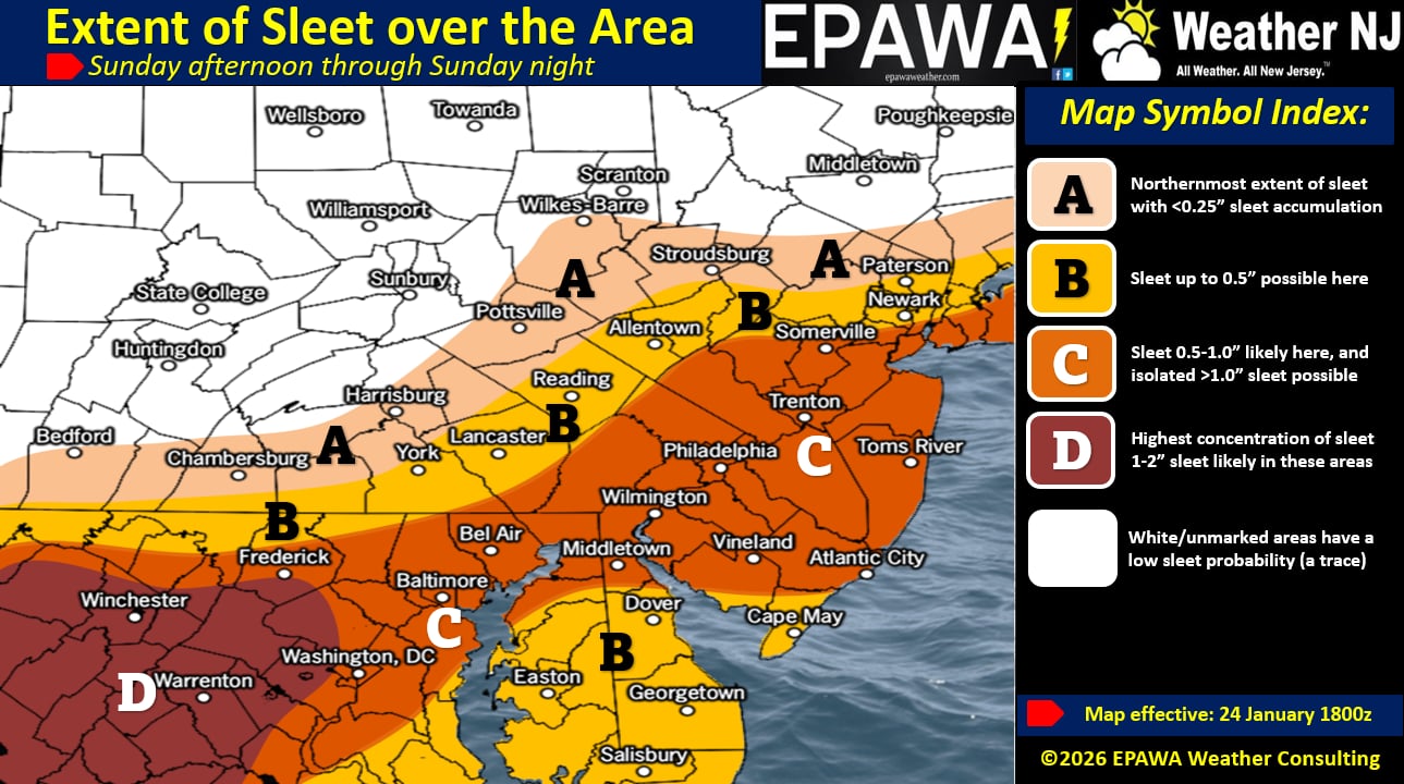
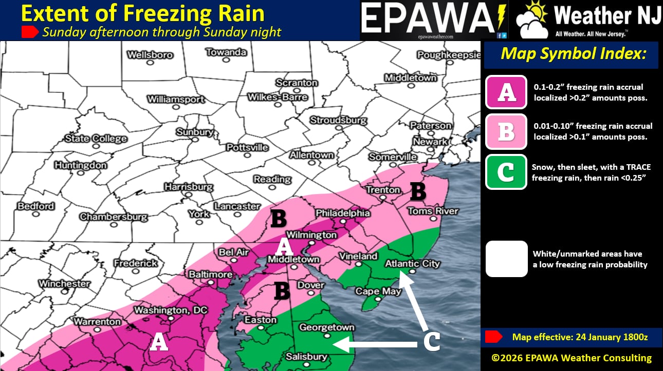
Phase II (Noon Sunday through 11pm Sunday): Around noon on Sunday, sleet will invade SNJ and take about 1-2 hours to reach and spread across SNJ all the way to the I-95/NJTP general corridor. During this time, zone C on our map will still snow 1-2 more hours before the transition. If you are still seeing 1-2 inch per hour snow rates, that could add an additional 1-2/2-4 inches of snow before the transition. The sleet should then continue to spread past (to the NW of) the I-95/NJTP corridor and come to a rest somewhere between I-95 and I-78. Therefore, by about 3-4pm, I expect CNJ to be finished with accumulating snow. Noon Sunday to about 3-4pm Sunday should feature a nasty sleet storm. You can call it a slizzard if you want. It might accumulate an inch or more of sleet on top of whatever snow you have in CNJ/SNJ. NNJ will remain all snow during this phase which is why they will continue to accumulate more snow towards the final outcome. Then from about 3-4pm until 11pm Sunday, sleet will convert to freezing rain all the way to I-95/NJTP, maybe a hair beyond and extreme SENJ will convert to plain rain. We expect precipitation to taper off for all areas except the KABOOM zone N of I-78 at this time. This will conclude phase II of the Arctic snowstorm approaching New Jersey.
Phase III (11pm Sunday through 10am Monday): Around 11pm Sunday night, we expect CNJ and SNJ to stop precipitating. NNJ, however (N of I-78), could hang onto some back-end lighter snow showers which will continue to contribute to their mostly all snow solution. Is it possible some of these NNJ snow showers are pulled southward into CNJ/SNJ by the departing low? Sure but likely won’t move the needle much on total snow accumulations. A fresh dusting/coating on top of the ice encrustation maybe. We expect these lighter snow showers to persist, mainly for NNJ, through mid-to-late morning Monday.
The Miller-B transfer process has evolved but not in a way that’s going to prevent the changeover to sleet, freezing rain and rain for I-95 and SE. There’s some play as to how far NW of I-95 that makes it, but not much at this point. We’ve put together three maps for you: one for snow, one for sleet, and then one for ice. The snow map is for the entirety of the storm (tonight through Monday morning) however CNJ/SNJ see all their snow in phase I while NNJ sees mostly snow for all phases. The sleet map is for the first part of phase II and the freezing rain/rain map is for the second part of phase II. Anything that changes back over to snow and falls during phase III is covered by the snow map. And that will conclude the third and final phase of the Arctic snowstorm approaching New Jersey.
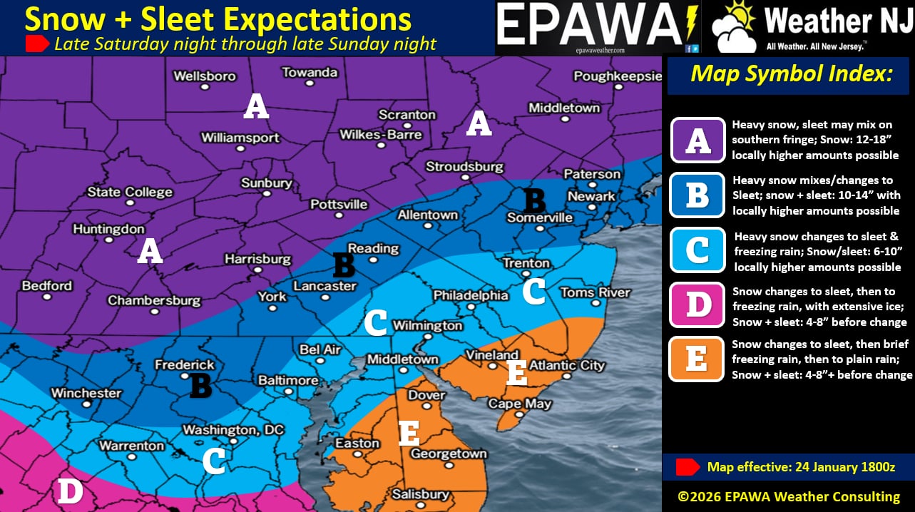
In English: An Arctic snowstorm is approaching New Jersey. The snowstorm begins late tonight and ends Monday morning making Sunday an all-day high-impact wintry event. NNJ should stay mostly snow throughout the entire storm and therefore a KABOOM WARNING has been issued for NNJ (N of I-78). A KABOOM WATCH remains in effect for all of NJ as a wildcard possibility. Otherwise, our conservative approach is illustrated in our above wintry impact maps and timing is laid out in the above-described phases. I will put a YouTube video out later this evening going over everything covered in this article plus any live observation points of interest. Please make sure you are prepared for severe cold to last a few weeks. While this will not be a high wind event, it will only mitigate power outages not prevent them entirely. There will still be a freezing rain period where tree branches could gain weight, break and fall on power lines + any accidents involving power line poles, etc. But we won’t have high winds. Everyone have a great rest of your Saturday and please be safe! JC
Premium Services
KABOOM Club offers an ad-free environment, inside info (Above and Beyond) forecast discussion, your questions prioritized, and early storm impact maps and video releases (ahead of the public). At $1.99 per month, it’s an extremely feasible way to show additional support for Weather NJ and you can turn it on and off for however many months you wish. Think of it as a tip jar with perks. Available onFacebook or Patreon.
My Pocket Meteorologist (MPM), in partnership with EPAWA Weather Consulting, offers professional/commercial interests, whose businesses depend on outdoor weather conditions (snow plowing, landscaping, construction, etc.), with hyper-local text message alerts/forecasts from real meteorologists and access to the MPM premium forum—the most comprehensive and technical forecast discussion available for PA and NJ commercial interests.
KABOOM Shop is live if you want some KABOOM or Weather NJ Merch!
Sign up for ZoneWatch Radar and get 10% off
Jonathan Carr (JC) is the founder and sole operator of Weather NJ, New Jersey’s largest independent weather reporting agency. Since 2010, Jonathan has provided weather safety discussion and forecasting services for New Jersey and surrounding areas through the web and social media. Originally branded as Severe NJ Weather (before 2014), Weather NJ is proud to bring you accurate and responsible forecast discussion ahead of high-stakes weather scenarios that impact this great garden state of ours. All Weather. All New Jersey.™ Be safe! JC


LOCAL FORECAST | INTERACTIVE RADAR | LATEST NJ WEATHER ALERTS | WEDDING FORECAST| PRIVACY POLICY
© Copyright 2026 Weather NJ LLC. All Rights Reserved.
Some information that can be found on our website is provided by a private weather station and is not an officially recognized station for weather reporting. Though we always strive to achieve accurate reporting for our own use, it is important that you do NOT depend on the data provided here for any purpose.
