

Arctic Weekend Snowstorm a Go for New Jersey
Discussion: This weekend winter snowstorm is a go. Again, deep breath everyone, we are still 3 and a half days from first flakes.
Model guidance began a northward trend yesterday and then kicked into a second gear trend northward overnight. It’s still a massive winter storm and snowstorm for much of NJ as it currently stands. There are a few changes though so let’s dive in.
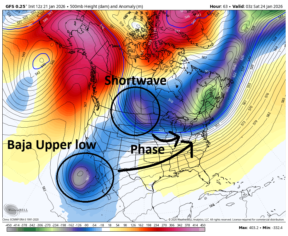
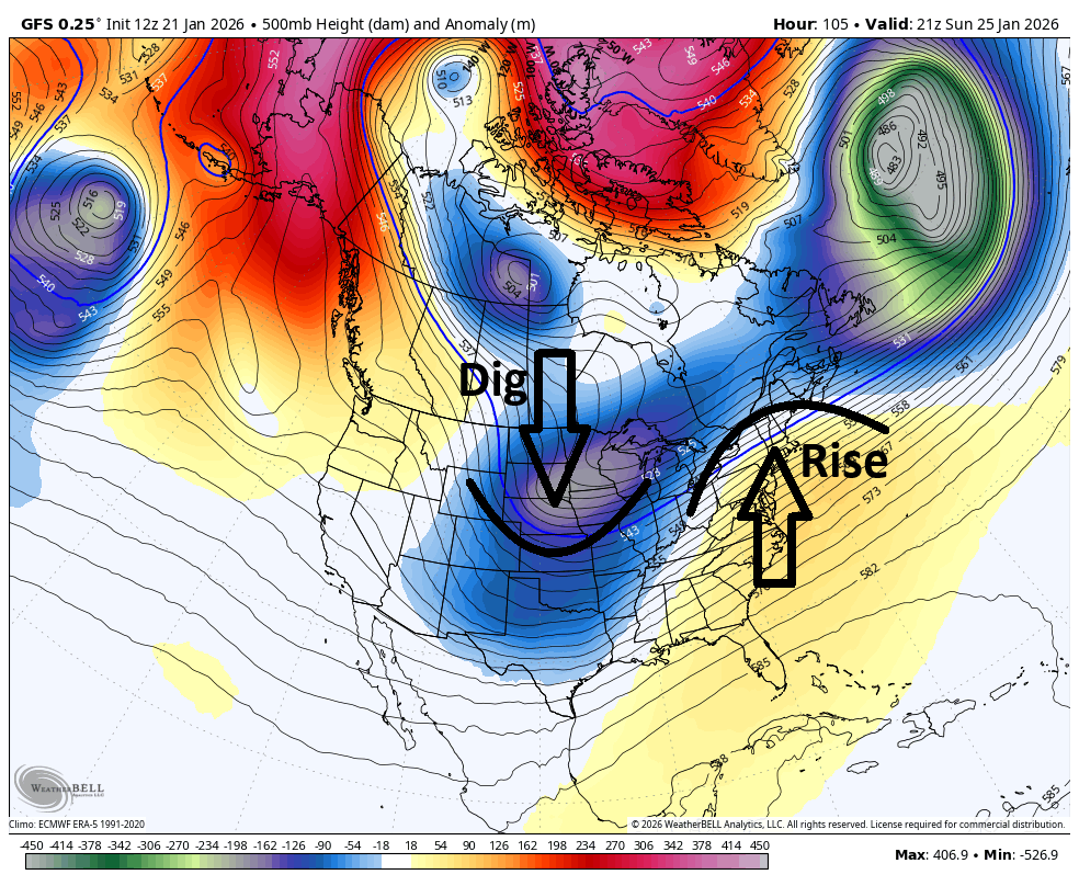
First at the upper levels, the cold air is moving into the north-central US, down into the plains and over towards the Mid-Atlantic US. This is the Arctic air mass that will eventually make its way and settle through NJ by this Saturday (milder today through Friday). Once this settles in, we’ll have an established thermal gradient running rather zonal (W to E from N Texas through about North Carolina. Areas to the N of this thermal gradient cold as heck and areas S of it, just stale normal cold/just above freezing. This flat thermal gradient will then be influenced in the upper levels by an upper low (UL) coming off the Pacific Ocean over the Baja Peninsula. The Baja UL will then phase into a shortwave moving in from W Canada. If the phase is weaker and the Baja UL is slower, then it will not dig the trough and in-turn keep the thermal gradient further S along the E US. If the Baja UL phases in quicker and remails quicker ahead of the shortwave, then it will raise the thermal gradient northward along the E US coast for a warmer outcome. So that Baja UL and how quick or slow it phases into the shortwave, is what I am looking at in the upper levels. The following images show first the phasing mechanics and then the affect is has on the storm trough and east coast heights.
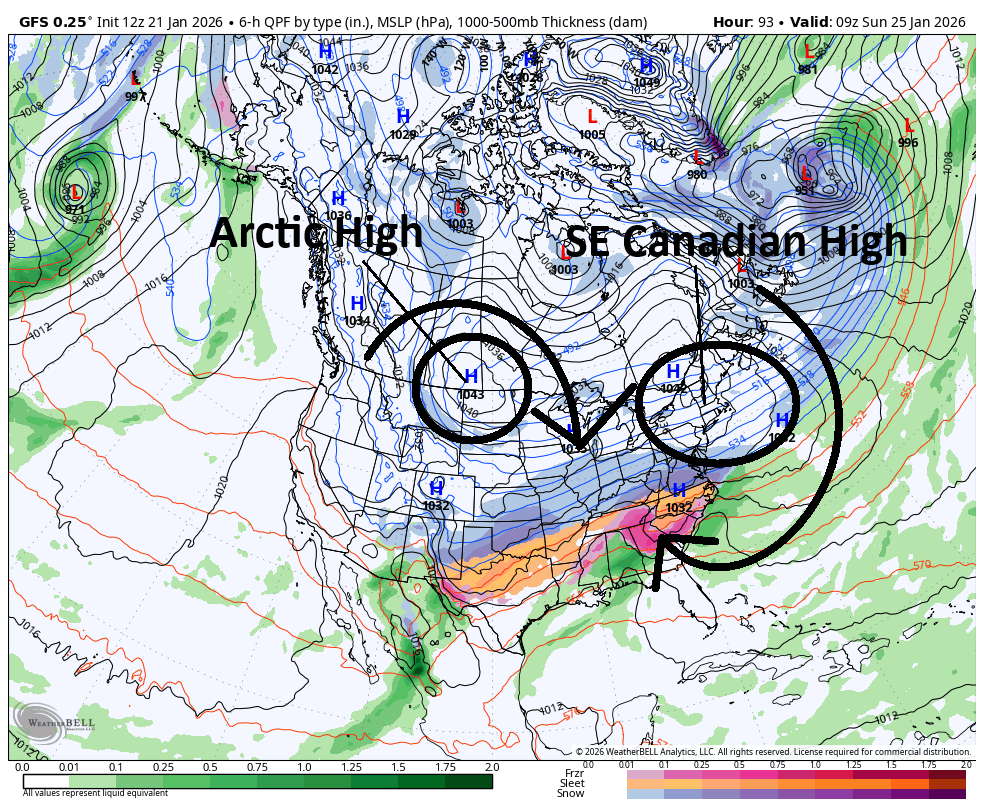
At the lower-mid levels, it’s all about high pressure in the Arctic air mass that will be stretching across much of the N US (from plains and N over to North Carolina and N. There are are lots of baby high pressures being seen in this entire air mass and that makes sense. Super cold air falls and condenses, the downward air motion squashes out a bunch of high pressure. But within that Arctic air sea of high pressure, will be two primary highs with a large enough scope to rotate synoptic scale (region-wide) air anti-cyclonically (clockwise) around it. The first high will be more over the N Plains area and the second high in the SE Canada area. The first high is mostly associated with driving the Arctic air down and into the US. The second high will have significant impact on the thermal gradient. The front (E side) of the SE Canadian high will push the thermal gradient S. The S side of the SE Canadian high will hold the thermal gradient in place. The back (W side) of the SE Canadian high will yank the thermal gradient northward. So it is very important whether the SE Canadian high will stay on top of (to the N of) the storm low or out ahead of it, driving warmth northward into the precipitations shield. The following image shows this general idea.
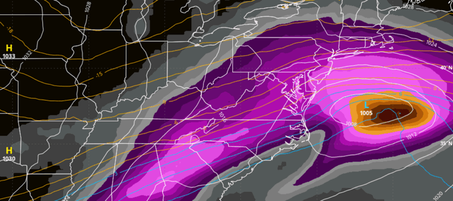
The reason for the trend northwards in model guidance has been because of a quicker Baja UL phase and the SE Canadian high getting out E in front of the storm. Even with a warmer solution, we’re still looking at 15:1 to 20:1 snow ratios where it does snow because of the intense thermal gradient that will be in place. Only for areas that mix over to sleet would drop to closer to 10:1. If it was stale Canadian winter air, the ratios would lower in a situation like this. But you’re going to see how strong this Arctic air mass really is come Saturday.
It’s interesting to note that hurricane hunters have dropped radiosondes into the Baja UL last night which immediately made the GFS come north to a big hit. The fresh flight data also made the Canadian, Euro and others respond more to the north. But they were already showing statewide snow only hits. So they now show mostly snow N of I-195 but with some sleet mixing in Along and SE of the I-95/NJTP corridor. IMO from this point, this could be an overcorrection to the initial flight data and will smooth out between a windshield wiper effect of snow/sleet axis. We cannot rule out a period of sleet getting into SENJ. But such an occurrence is now being seen on most models as a few hour thing after a 8-16 inch snow drop initially.
After reviewing the 12z data suite, I am leaning towards a solution where most of NJ gets rocked with a KABOOM. I am leaning towards a period of sleet possibly pushing as far in as I-95/NJTP but also possibly only pushing into extreme SNJ/SENJ. The Arctic air mass is for real and it makes little meteorological sense for a low this weak to drive too far into that Arctic cold air mass of high pressure. But we will continue to track seriously the rest of today and tomorrow before we likely issue our first call snow map Friday. At some point between today and tomorrow a KABOOM WATCH will likely be issued. A watch means that chances are increasing/likely to happen but can also be taken down if there are 11th hour changes in the atmosphere detected by the models. If the status quo holds, a KABOOM WARNING will be issued with our final call snow map on Saturday. A KABOOM is 12 inches of snow of more for those who aren’t familiar with Weather NJ. And a “Dude Where’s my Carr? Is 24 inches or more. A DWMC can only be called once into a storm if snowfall is exceeding expectations in a case like this.
In English: A high-impact Arctic snowstorm/winter storm is a go for this weekend between about 2am Sunday into Monday morning/noon. Some ice/sleet possible for SENJ but leaning toward more snow than ice overall for NJ. One more day of serious tracking tomorrow then snow maps Friday and Saturday before live observations begin Sunday AM. Be safe! JC
Premium Services
KABOOM Club offers an ad-free environment, inside info (Above and Beyond) forecast discussion, your questions prioritized, and early storm impact maps and video releases (ahead of the public). At $1.99 per month, it’s an extremely feasible way to show additional support for Weather NJ and you can turn it on and off for however many months you wish. Think of it as a tip jar with perks. Available onFacebook or Patreon.
My Pocket Meteorologist (MPM), in partnership with EPAWA Weather Consulting, offers professional/commercial interests, whose businesses depend on outdoor weather conditions (snow plowing, landscaping, construction, etc.), with hyper-local text message alerts/forecasts from real meteorologists and access to the MPM premium forum—the most comprehensive and technical forecast discussion available for PA and NJ commercial interests.
KABOOM Shop is live if you want some KABOOM or Weather NJ Merch!
Sign up for ZoneWatch Radar and get 10% off
Jonathan Carr (JC) is the founder and sole operator of Weather NJ, New Jersey’s largest independent weather reporting agency. Since 2010, Jonathan has provided weather safety discussion and forecasting services for New Jersey and surrounding areas through the web and social media. Originally branded as Severe NJ Weather (before 2014), Weather NJ is proud to bring you accurate and responsible forecast discussion ahead of high-stakes weather scenarios that impact this great garden state of ours. All Weather. All New Jersey.™ Be safe! JC


LOCAL FORECAST | INTERACTIVE RADAR | LATEST NJ WEATHER ALERTS | WEDDING FORECAST| PRIVACY POLICY
© Copyright 2026 Weather NJ LLC. All Rights Reserved.
Some information that can be found on our website is provided by a private weather station and is not an officially recognized station for weather reporting. Though we always strive to achieve accurate reporting for our own use, it is important that you do NOT depend on the data provided here for any purpose.
