

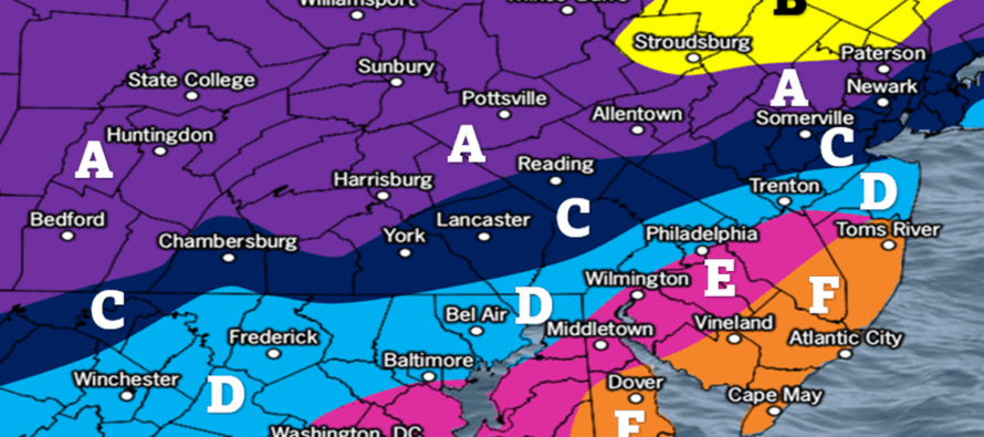
Arctic Weekend Snowstorm NJ Accumulation Map
Discussion: If you’ve been following along then by now you should have made all preparations for a high-impact wintry event in New Jersey this weekend. This includes all your French Toast ingredients, food, plans to stay warm, etc. This snowstorm kicks off a prolonged period of what some consider to be dangerous cold. The pipe-bursting stuff. Tuesday morning low temperatures should range from 0-10 NNJ to SNJ for most of NJ. Only the immediate coastal regions and barrier island should make it over 15. Tuesday highs max out in the 15-20 range before all of NJ returns to a balmy -10 to 5 NNJ to SNJ overnight low situation (immediate coasts maybe 10-15). And onward the prolonged Arctic temperatures go throughout the rest of January and into a good portion of February.
In a more immediate forecast, temperature overnight tonight should crash to about the 5-15 range NNJ to SNJ by Saturday morning. Highs should then range from about 10-20 NNJ to SNJ on Saturday afternoon with dry mostly sunny conditions. So how much snow will NJ get?
Anytime around midnight or shortly after, precipitation will saturate SWNJ/SNJ enough to begin snowing. Snow will then make it into zones D, C, A and finally B of our snow map a few hours after it begins in SWNJ. Temperatures at that time should be about 15-20 in SWNJ/SNJ (closer to 10 in NNJ). This will set up a high snow ratio environment until temps rise to about 27-ish by noon. Therefore, up to a 12-hour period of high ratio snowfall is possible for SNJ between midnight and noon on Sunday morning (phase 1 of this storm). It would begin light, transition to moderate, and end heavy. This is when zones E and F on our map below will obtain their snow accumulations. If this initial burst of precipitation is early or performs above expectations, then our map could be too low for those areas regarding how much snow NJ will get, especially in SNJ. But a conservative approach is needed for these zones given the warm air advection potential.
Phase 2 of the storm would then begin around noon or just after on Sunday. This is when the WAA should push into SENJ from the ocean and ultimately settle somewhere near or just NW of I-95. Could the sleet max out SE of I-95? Sure, it could. An Arctic wall could set up and give a big FU to the WAA. But this is lower probability despite not off the table. The more reasonable expectation currently is for the snow/mixing line to reach the I-95 corridor, possibly just NW of it. Last night I mentioned how the NW extent might not be as far given the colder Arctic environment. And where it does sleet near or just NW of I-95 would be more of a snow with sleet mixed in kind of thing due to a shallow, easily collapsable with heavy precip, warm layer. But we’ve factored all of this into our best first guess of ranges at this time. We believe zones B and A will KABOOM. We suspect zone C could easily KABOOM. If anywhere in zone D is going to have a chance, it would be just N of Trenton and maybe some of Monmouth County. Everyone along and S of I-195 has a much less chance for a KABOOM at this point though could still see significant accumulations from the initial phase 1 burst. Phase 2 of the storm will conclude when the snow/sleet line has reached its furthest NW extent and has begun advancing back to the SE. This is when we believe zone E could convert from sleet to freezing rain and for zone F to convert to plain rain (in the warmest part of the storm for SENJ at the warmest case of the storm). If only sleet makes it into SENJ then watch out for how much snow NJ gets. We believe this to be sometime Sunday night before midnight.
Phase 3 begins with the snow/sleet line advancing back to the coast behind the ocean-established low offshore, likely by late Sunday night. It will not be a super powerful low, so wind concerns are slightly mitigated. Models are split on precipitation either ending abruptly by Monday morning in whatever p-types they are in or lingering until as late as noon-ish Monday. In the case of lingering, this could drop another C-2/1-3 across SNJ as the very cold air will be back involved in higher snow ratios. This is yet to be determined. But the third phase of the storm ends no later than noon-ish Monday and then we enter the prolonged and enduring period of bitter cold temperatures.
The main reasons why this storm came northward were because 1) the Baja low phasing better with the shortwave in the W/C US, digging a deeper storm trough and in-return raising geopotential heights along the E US coast. 2) The SE Canadian high pressure weakening, retreating and getting ahead of (to the E) the storm’s main low-pressure. That’s what opens up the 6-12 hour window of weakness for warmth to temporarily punch into the Arctic suppressive air (phase 2 of storm). Otherwise, it’s occurring in some of the coldest Arctic air in the N Hemisphere driven down by the +EPO/-PNA signal we identified almost 2 weeks ago for this period. How much snow NJ will get is now up to the mesoscale features.
Models have halted their northward trend for the most part and have ticked a little colder. I believe this to be because of the configuration of the Miller-B transfer mechanism changes being picked up. The primary is no longer into Pittsburg, possibly Lake Ontario, before the transfer like some of the guidance ridiculously indicated. The primary is now into Alabama/Georgia on the GFS, into W Virginia on the Canadian, and into the TN/NC border on the Euro. This drags less warmth into the WV/W MD/PA areas which means a colder outcome across NJ. It’s not going to push the needle much. The difference has meant maybe an extra inch or two in the jackpot zone and maybe a little less/later mixing for the warmer SNJ locations. Now if we see the secondary low start to spawn a little E of where it is in response to the primary being more E than N, then models will continue colder ticks on the data guidance tonight into tomorrow. We’ll have time to adjust our map accordingly either way tomorrow. But for now, here’s our current snow map created with evidence-based data principles and in a conservative nature for how much snow NJ will get:
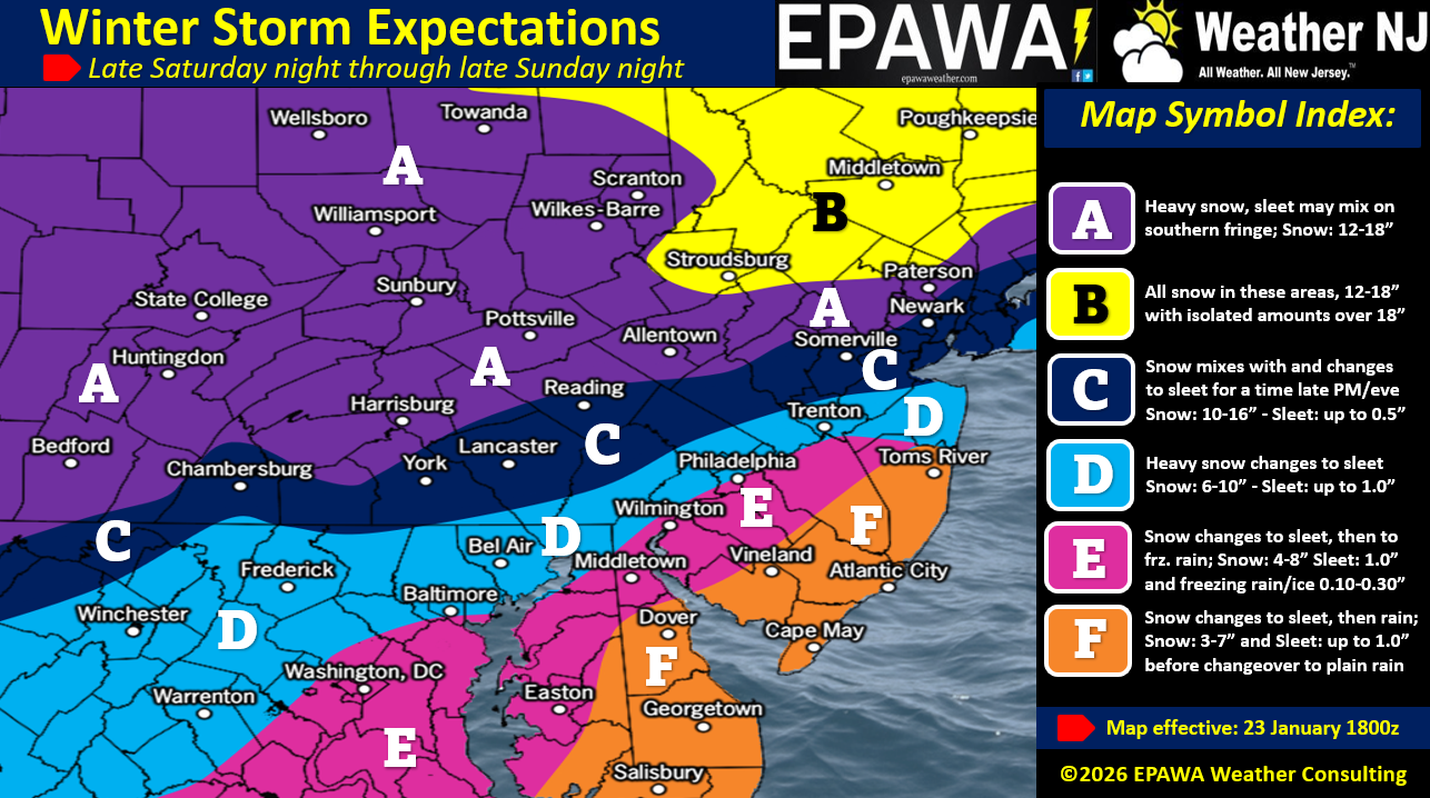
In English: It will turn much colder tonight into tomorrow but tomorrow looks dry. Light snow then moves in around midnight or slightly after (Sunday morning) and increases to moderate then heavy statewide until about noon on Sunday (phase 1 of storm). Precip then begins mixing SE to NW across SENJ, ultimately turning all areas along and SE of I-95/NJTP over to at least sleet and possibly freezing rain/plain rain further S (phase 2 of storm). NW extend of sleet highly uncertain but looking between I-95 or maybe 20-30 miles NW of. A KABOOM is still looking good for NNJ (N of I-78, possibly N of I-195). S of I-195 and SE of I-95 not so much. Mixing then changes back to snow and precipitation ends no later than noon-ish Monday but possibly earlier Monday morning (phase 3 of storm). This end time is still uncertain. A KABOOM Watch remains in effect for all areas N of I-195/NW of I-95 regardless of our snow map amounts but only as a possibility, not a guarantee especially for S C zone and N D zone. A KABOOM Warning will be issued with tomorrow’s update for appropriate regions. I’ll put another video out tonight to see how the forecast is holding through evening data updates. A final note that this is again, a high-impact wintry event happening in a sea of Arctic cold air. That goes regardless of whether you see 12-29+ inches of snow, 8-12 inches of snow followed by a slizzard or just 3-8 inches of snow followed by an ice accrual and/or plain rain falling on a fresh 32-degree snow pack. Widespread travel disruption likely so make sure you are all set by Saturday evening. Have a great Friday night otherwise and please be safe! JC
Premium Services
KABOOM Club offers an ad-free environment, inside info (Above and Beyond) forecast discussion, your questions prioritized, and early storm impact maps and video releases (ahead of the public). At $1.99 per month, it’s an extremely feasible way to show additional support for Weather NJ and you can turn it on and off for however many months you wish. Think of it as a tip jar with perks. Available onFacebook or Patreon.
My Pocket Meteorologist (MPM), in partnership with EPAWA Weather Consulting, offers professional/commercial interests, whose businesses depend on outdoor weather conditions (snow plowing, landscaping, construction, etc.), with hyper-local text message alerts/forecasts from real meteorologists and access to the MPM premium forum—the most comprehensive and technical forecast discussion available for PA and NJ commercial interests.
KABOOM Shop is live if you want some KABOOM or Weather NJ Merch!
Sign up for ZoneWatch Radar and get 10% off
Jonathan Carr (JC) is the founder and sole operator of Weather NJ, New Jersey’s largest independent weather reporting agency. Since 2010, Jonathan has provided weather safety discussion and forecasting services for New Jersey and surrounding areas through the web and social media. Originally branded as Severe NJ Weather (before 2014), Weather NJ is proud to bring you accurate and responsible forecast discussion ahead of high-stakes weather scenarios that impact this great garden state of ours. All Weather. All New Jersey.™ Be safe! JC


LOCAL FORECAST | INTERACTIVE RADAR | LATEST NJ WEATHER ALERTS | WEDDING FORECAST| PRIVACY POLICY
© Copyright 2026 Weather NJ LLC. All Rights Reserved.
Some information that can be found on our website is provided by a private weather station and is not an officially recognized station for weather reporting. Though we always strive to achieve accurate reporting for our own use, it is important that you do NOT depend on the data provided here for any purpose.
