

Tropical Model Guidance
The Latest on Arthur
It’s important to understand what exactly is going to happen between Thursday night and Friday night. A cold front will be coming through our region on Thursday evening from the WNW. This will have it’s own associated rain and storms (possibly severe) that have nothing to do with Arthur…yet. These showers and storms will likely last overnight into Friday.
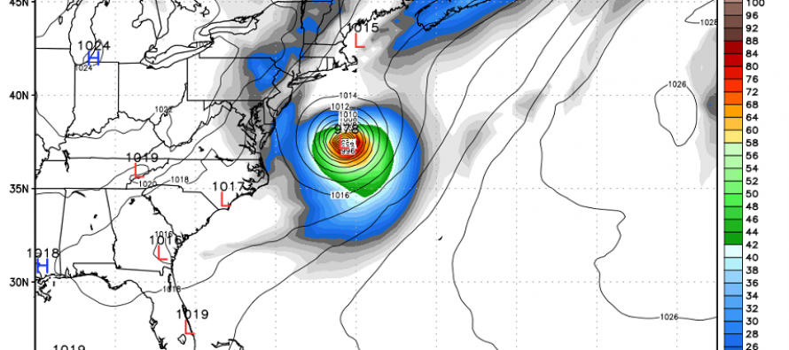
On Friday morning, the absolute NW outer bands of Arthur could potentially interact with lingering showers from the frontal passage. The front will still be close to the Jersey Shore. This could keep Friday wet (especially for SENJ and barrier islands) but only until the afternoon hours. By late Friday afternoon, the front should be doing it’s job pushing Arthur ENE and out to sea. This is the latest Euro showing where Arthur will be just before sunset on Friday.
There is debate how strong Arthur will get. Most guidance indicates at least Tropical Storm intensity with Category 1 hurricane strength on the table. Coastal SC/NC will likely see the heaviest impact from Arthur Friday morning. Regardless, surf and rip currents along coastal NJ (Cape May to Sandy Hook) will be intensified for at least Friday and Saturday so listen to life guards and respect the sea!
With all of this being said, there’s a decent chance of Friday evening drying out but with possible northerly winds. Sat and Sun still look pretty good. Between the frontal passage and Arthur, most of the humidity should be carried away for a decent holiday weekend. I’ll have the full July 4th Weekend Outlook posted Thursday evening along with a surprise announcement. Be safe! JC
Jonathan Carr (JC) is the founder and sole operator of Weather NJ, New Jersey’s largest independent weather reporting agency. Since 2010, Jonathan has provided weather safety discussion and forecasting services for New Jersey and surrounding areas through the web and social media. Originally branded as Severe NJ Weather (before 2014), Weather NJ is proud to bring you accurate and responsible forecast discussion ahead of high-stakes weather scenarios that impact this great garden state of ours. All Weather. All New Jersey.™ Be safe! JC


LOCAL FORECAST | INTERACTIVE RADAR | LATEST NJ WEATHER ALERTS | WEDDING FORECAST| PRIVACY POLICY
© Copyright 2025 Weather NJ LLC. All Rights Reserved.
Some information that can be found on our website is provided by a private weather station and is not an officially recognized station for weather reporting. Though we always strive to achieve accurate reporting for our own use, it is important that you do NOT depend on the data provided here for any purpose.
