

Aug 19: Widespread Rainfall Expected
The warmer temperatures as of late should fall back within seasonably average parameters for mid-to-late August as we head into the weekend. Conditions, however, should remain unsettled through Monday with widespread rainfall likely at times. Short-range model guidance indicates that the heaviest rainfall will occur along a slow moving cold front tomorrow into Friday making such the wettest days in the forecast. Saturday, Sunday and even Monday should remain unsettled but should also feature extended periods of sun and clouds without rain.
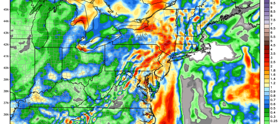
A weak area of low pressure in the Atlantic Ocean could actually back some of the moisture that came through with the cold front—in off the ocean and as far W as E. PA. It might be Tuesday until all remnant showers dissipate throughout the region. This 12Z GFS model image, used with permission from WeatherBell Analytics, represents total precipitation through Sunday night (with most rainfall occurring tomorrow through Friday):
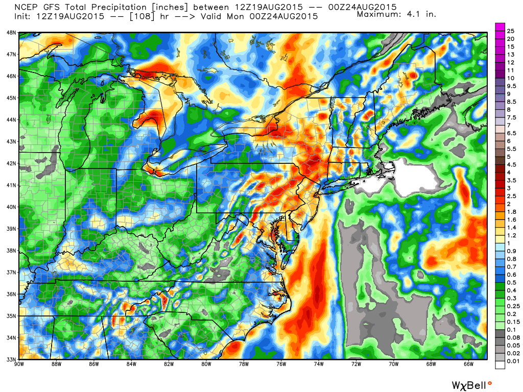
In English: Expect unsettled conditions through Monday with Thursday and Friday likely featuring the most rainfall. Today, Saturday, Sunday and Monday should still be unsettled (isolated shower and storms) but feature breaks of sun. All this while remaining cooler than the latest heat wave we’ve had. I expect afternoon high temperatures each day to only reach the upper-70s (NNJ Elevations) and lower-80s (rest of New Jersey). I’ll have the fully detailed Weekend Outlook posted tomorrow. Be safe! JC
Jonathan Carr (JC) is the founder and sole operator of Weather NJ, New Jersey’s largest independent weather reporting agency. Since 2010, Jonathan has provided weather safety discussion and forecasting services for New Jersey and surrounding areas through the web and social media. Originally branded as Severe NJ Weather (before 2014), Weather NJ is proud to bring you accurate and responsible forecast discussion ahead of high-stakes weather scenarios that impact this great garden state of ours. All Weather. All New Jersey.™ Be safe! JC


LOCAL FORECAST | INTERACTIVE RADAR | LATEST NJ WEATHER ALERTS | WEDDING FORECAST| PRIVACY POLICY
© Copyright 2026 Weather NJ LLC. All Rights Reserved.
Some information that can be found on our website is provided by a private weather station and is not an officially recognized station for weather reporting. Though we always strive to achieve accurate reporting for our own use, it is important that you do NOT depend on the data provided here for any purpose.
