

Aug 23: Important Tropical Update!
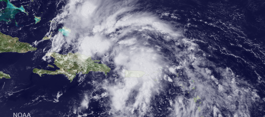
Tropical development continues to be slow in the Dominican Republic/Puerto Rico region. Higher elevations of the W. Greater Antilles have taken their toll on the system currently being investigated (Invest 96L). Intensification, however, is expected today-tonight as it moves into the Bahamas region before turning northward as seen here on model guidance. The track is still sprayed pretty wide but the near-mean average over the immediate future takes it towards the east coast.
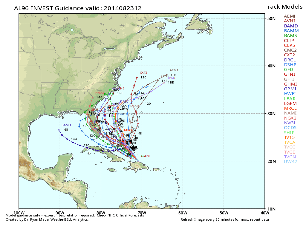
While a re-curve is still anticipated at some point, it’s becoming more apparent that this system “could” pass just close enough to New Jersey to bring some rain, wind and coastal flooding early to mid-week. That would probably be the most western solution of possibilities but it’s on the table. Should the system take a track that’s a little more east, we might just be on the hook for rough surf. Anything between those two scenarios is possible. Here’s the latest update from the NWS National Hurricane Center, straight from air recon:
SPECIAL TROPICAL WEATHER OUTLOOK
NWS NATIONAL HURRICANE CENTER MIAMI FL
1025 AM EDT SAT AUG 23 2014

For the North Atlantic...Caribbean Sea and the Gulf of Mexico:

Special outlook issued to discuss results of aircraft
reconnaissance mission.

1. Updated...Reports from an Air Force Reserve Hurricane Hunter
aircraft and satellite imagery indicate that the disturbance located
near Hispaniola continues to lack a well-defined surface
circulation. As a result, advisories are not being initiated at this
time. However, environmental conditions are favorable for the
development of a tropical depression or tropical storm later today
or Sunday. Another Air Force Reserve Hurricane Hunter aircraft is
scheduled to investigate the system this afternoon.

This disturbance is forecast to move west-northwestward over or near
the southeastern Bahamas today, and over or near the central Bahamas
Sunday and Sunday night. Heavy rains and gusty winds are expected to
continue over Puerto Rico and Hispaniola today. Winds to tropical
storm force and heavy rains are expected to spread over the
southeastern Bahamas, the Turks and Caicos Islands, and the central
Bahamas through Sunday night. These rains could cause life-
threatening flash floods and mudslides, especially in mountainous
areas of Hispaniola and Puerto Rico. Interests in the Turks and
Caicos and all of the Bahamas should monitor the progress of this
disturbance, since tropical storm watches and warnings could be
required with little advance notice.
* Formation chance through 48 hours...high...80 percent.
* Formation chance through 5 days...high...90 percent.

Forecaster Brennan
I wouldn’t be surprised if this forms into a named storm later tonight/early tomorrow AM. It’s entering a very favorable environment for intensification. One thing to keep in mind is that if this does come up the coast towards NJ, it will likely be weak from so much interaction with coastal SE US land. Coastal flooding after a week of onshore flow would be the headline, not the breezy-windy showers that would accompany such. I’ll continue to monitor this system very closely. Be safe! JC
Satellite image from NOAA. Model image reproduced with permission from WeatherBell Analytics.
Jonathan Carr (JC) is the founder and sole operator of Weather NJ, New Jersey’s largest independent weather reporting agency. Since 2010, Jonathan has provided weather safety discussion and forecasting services for New Jersey and surrounding areas through the web and social media. Originally branded as Severe NJ Weather (before 2014), Weather NJ is proud to bring you accurate and responsible forecast discussion ahead of high-stakes weather scenarios that impact this great garden state of ours. All Weather. All New Jersey.™ Be safe! JC


LOCAL FORECAST | INTERACTIVE RADAR | LATEST NJ WEATHER ALERTS | WEDDING FORECAST| PRIVACY POLICY
© Copyright 2026 Weather NJ LLC. All Rights Reserved.
Some information that can be found on our website is provided by a private weather station and is not an officially recognized station for weather reporting. Though we always strive to achieve accurate reporting for our own use, it is important that you do NOT depend on the data provided here for any purpose.
