

Aug 23: Still Watching the Tropics
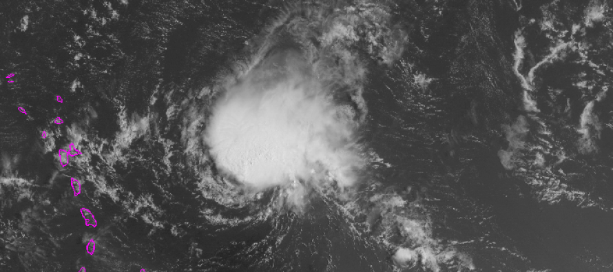
Danny has been weakening over the last 24-36 hours due to an unfavorable upper level environment of wind shear and dry air. He will continue to weaken in tropical cyclone intensity but should still bring widespread heavy rainfall to the Leeward Islands of the Lesser Antilles Monday into Tuesday. At this point, I give Danny an 90% chance of fizzling into just tropical remnants by the time he passes just to the north of Hispaniola. With that said, I give it a 10% chance that enough remnant energy makes it through into the Bermuda Triangle to re-intensify. In either case, US impact chances are very low but not confident enough to say zero at this time. Let’s look at a surface map of the Atlantic Ocean:
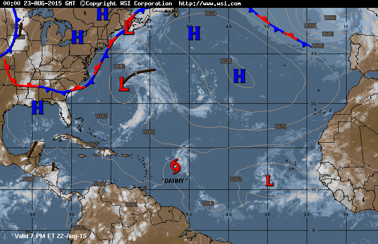
Danny is clearly labeled but other areas of possible tropical development are represented as “L” simply meaning low pressure. The low off Maine should be ignored as tropical development is unlikely at that latitude—rain maker for Nova Scotia at most. The area of low pressure off OBX could intensify further but should stay out to sea. The area off western Africa is yet another Cape Verde system to watch and should actually take a similar path as Danny, but in his wake of lower shear. Then there’s even another area behind that but still over Africa and only a developing wave for now. With that said, the tropics are heating up—right on queue for peak hurricane season.
I’ll continue to watch and report on Danny but at this time, despite the increase in overall tropical activity, no threats exists for New Jersey. If the very low chance of Danny making it through the NE Caribbean and turning up the coast is realized, then we’ll go from there. We have 2-3 days before being able to determine such. My web site traffic analytics indicate that many are tuning in from the Caribbean, Bahamas, and Florida-Cape Cod. Must be a lot of travel to and from NJ this time of year coupled with new interests simply finding us. With that said, welcome to Weather NJ!
Today in New Jersey looks partly cloudy, clearer in western parts of NJ but possibly overcast with even some drizzle for eastern coastal regions. Nothing crazy, only a possible nuisance and likely after noon. I’ll have the full Monday-Friday Outlook posted later this evening. Be safe! JC
Jonathan Carr (JC) is the founder and sole operator of Weather NJ, New Jersey’s largest independent weather reporting agency. Since 2010, Jonathan has provided weather safety discussion and forecasting services for New Jersey and surrounding areas through the web and social media. Originally branded as Severe NJ Weather (before 2014), Weather NJ is proud to bring you accurate and responsible forecast discussion ahead of high-stakes weather scenarios that impact this great garden state of ours. All Weather. All New Jersey.™ Be safe! JC


LOCAL FORECAST | INTERACTIVE RADAR | LATEST NJ WEATHER ALERTS | WEDDING FORECAST| PRIVACY POLICY
© Copyright 2026 Weather NJ LLC. All Rights Reserved.
Some information that can be found on our website is provided by a private weather station and is not an officially recognized station for weather reporting. Though we always strive to achieve accurate reporting for our own use, it is important that you do NOT depend on the data provided here for any purpose.
