

Aug 24: Tropics Update
Danny has sheared apart into tropical remnants which verified the most-likely scenario. Remnants however will continue to impact the NE Caribbean with rainfall and only light-to-moderate tropical winds. The only thing worth watching is if such tropical remnants re-intensify “if” they make it into the Bermuda Triangle and there’s only a very small chance for that.
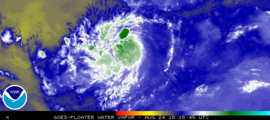
Invest 97L is no longer an issue (mostly just a contributor for some rough surf conditions along the mid-Atlantic coast). Attention now turns to Invest 98L which will take a similar track to Danny across the Atlantic Ocean and towards the NE Caribbean. While this storm could intensify and hold together longer than Danny did, it is currently projected on model guidance to curve out to sea before reaching the SE US coast. Invest 98L should be upgraded to Tropical Depression 5 in the extreme short-term (today) and ultimately Erika (maybe overnight or tomorrow AM). Satellite-based convection analysis indicates a developing center or circulation stacked with healthy thunderstorm development (high and cool cloud tops) directly overhead.
Another tropical wave exists behind Invest 98L however the NOAA National Hurricane Center has indicated an unfavorable environment for development in the short-term.
So basically RIP Danny and all eyes on Erika‘s development. No data supports an east coast threat at the moment. Will continue to track tropical activity approaching the Caribbean for those with travel interests to and from New Jersey. Be safe! JC
Jonathan Carr (JC) is the founder and sole operator of Weather NJ, New Jersey’s largest independent weather reporting agency. Since 2010, Jonathan has provided weather safety discussion and forecasting services for New Jersey and surrounding areas through the web and social media. Originally branded as Severe NJ Weather (before 2014), Weather NJ is proud to bring you accurate and responsible forecast discussion ahead of high-stakes weather scenarios that impact this great garden state of ours. All Weather. All New Jersey.™ Be safe! JC


LOCAL FORECAST | INTERACTIVE RADAR | LATEST NJ WEATHER ALERTS | WEDDING FORECAST| PRIVACY POLICY
© Copyright 2026 Weather NJ LLC. All Rights Reserved.
Some information that can be found on our website is provided by a private weather station and is not an officially recognized station for weather reporting. Though we always strive to achieve accurate reporting for our own use, it is important that you do NOT depend on the data provided here for any purpose.
