

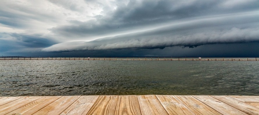
Aug 25: Storm Front Approaching
Discussion: New Jersey is currently on the W (back) side of a trough that is primarily developing over SE Canada and NE US. A small upper-level disturbance is rounding the back-side of this trough which is enhancing the jet streak of the back-side trough bottom. With that said we have some stronger upper-level dynamics which could enhance today’s potential severe weather event. This also puts our upper-level flow out of the NW and is ultimately driving a cooler and drier air mass into our region for tomorrow. As this air mass approaches it will encounter the soupy storm fuel surface environment currently in-place (dews of 70+ and diurnal instability). At the lower levels, the air mass is being primarily driven out of the N by the positive axis base rounding of energy around the trough. Therefore, today’s storms are going to come out of the N/NW.
We have adequate diurnal instability with the sun beating down to the surface all day (clear skies). We have enhanced upper-level dynamics by the jet configuration (shear and mixing). The surface is very saturated with moisture (high dew points). When this surface wedge of cold plows through (the trigger), there is nowhere for the hot and moist air mass to go but up into a cumulonimbus development cycle. And this cooler air mass features strong advection. This is not a front that will hang up over CNJ/SNJ. This front is going to push well S of Delmarva.
One thing I would like to mention is that the storm line could be broken and scattered if enough upper-level dry air inhibits a full linear segment of storm front generation. With that said, it is possible that some areas escape this storm line but that is not guaranteed. I would act as if it is coming since there is no way to predict the areas that see a potentially broken storm line.
For timing, it looks like the storms will approach NWNJ from the N/NW around 4-5pm today and will push through all of NJ from N/NW to S/SE. I expect the storm front to clear Cape May/SENJ around 10-11pm. So ~5-10pm for the storm front to scale NJ. That means CNJ seeing the front come through around 6-8pm. The duration of the event itself looks pretty quick. The line of modeled precipitation is not that thick. It might only take an hour (or less) for storms to approach, push through, and clear out.
In English: A line of strong-to-severe thunderstorms should push through NJ from N to S (NWNJ to SENJ) between about 5-10pm tonight. The event should take an hour or so to pass over your location (from approach through peak intensity to clear-out). For possible hazards during this event, pretty much everything is on the table. Heavy rain, gusty straight-line winds, and frequent lightning are the most probable events. Hail and possibly a tornado are less probable but possible given the dynamics. There is a small wildcard possibility for broken storm line segments meaning some areas could get missed. There’s no way to anticipate which areas those would be so best to just prepare for getting hit…for safety concerns. Once the storm front pushes through, all of NJ will experience a day of relief (from heat and humidity) tonight through Wednesday. Then Thursday we’re back to warm and humid as we anticipate weekend impacts from Laura remnants. Have a great night and please be safe! JC
Download the new free Weather NJ mobile app on Apple and/or Android. It’s the easiest way to never miss Weather NJ content. Our premium services go even further above and beyond at the hyper-local level. Looking for industrial-caliber long-range forecasting data that I personally recommend? Check out WeatherTrends360!
Jonathan Carr (JC) is the founder and sole operator of Weather NJ, New Jersey’s largest independent weather reporting agency. Since 2010, Jonathan has provided weather safety discussion and forecasting services for New Jersey and surrounding areas through the web and social media. Originally branded as Severe NJ Weather (before 2014), Weather NJ is proud to bring you accurate and responsible forecast discussion ahead of high-stakes weather scenarios that impact this great garden state of ours. All Weather. All New Jersey.™ Be safe! JC


LOCAL FORECAST | INTERACTIVE RADAR | LATEST NJ WEATHER ALERTS | WEDDING FORECAST| PRIVACY POLICY
© Copyright 2026 Weather NJ LLC. All Rights Reserved.
Some information that can be found on our website is provided by a private weather station and is not an officially recognized station for weather reporting. Though we always strive to achieve accurate reporting for our own use, it is important that you do NOT depend on the data provided here for any purpose.
