

Aug 28: Tropics Update
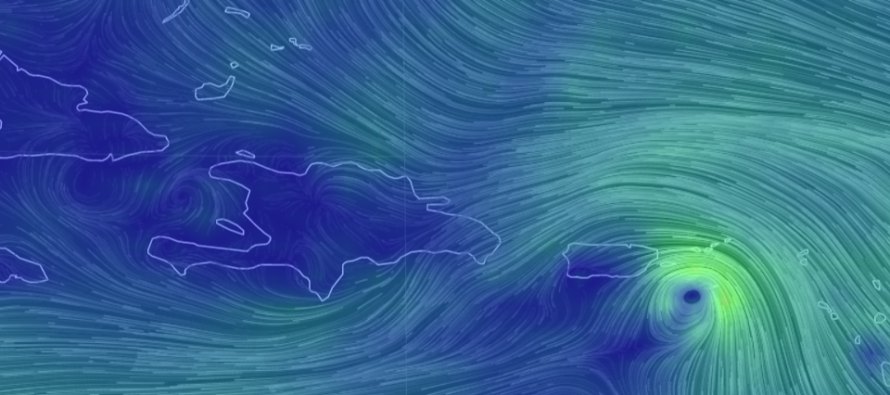
Discussion: All of a sudden the tropics are hot. Tropical Storm Erin should remain out to sea but residents along the SE US (Florida to OBX) should begin paying attention to the evolution of Tropical Storm Dorian. The upper-level pattern in the next 5 days or so is starting to come into focus on computer model guidance. Upper-level steering is taking Dorian on a route more over far-E Puerto Rico rather than Hispaniola. That’s been the most significant evolution in the last 48 hours as Dorian has taken the N/right side of the current NHC-expected track. We’ll have to watch if this trend continues into the Bermuda Triangle. This means larger impacts for Puerto Rico but nothing like Maria. Depending on the rate of intensification Puerto Rico will likely take a strong tropical storm or weak hurricane hit today. This also means that Dorian will escape the weakening and disorganizing influence of Hispaniola elevations.
So we’ll likely have at least a category 1 hurricane inside the Bermuda triangle tomorrow. At this point Dorian’s track will be completely dependent on two upper-level features. One is a trough swinging through the NE US this Friday-Saturday and the other is a trough swinging through the E US in the Tuesday-Wednesday period. These drivers will ultimately lift Dorian out of the easterly trade winds and into the returning westerlies at a higher altitude. The question is how much interaction they will each have.
European data is suggesting that ridging holds on stronger between the troughs. The GFS is suggesting lesser ridging and more weakness which would allow a sharper re-curve and therefore more interaction with the Tuesday-Wednesday trough. The difference at the surface is anything from a central E Florida landfall to a system that skirts the entire SE US from Florida to OBX. And there lies the current cone of uncertainty. Therefore I’ll be watching that upper-level pattern through the SE US and central Mid-Atlantic US to see how much ridging actually remains. There is nothing in the Bermuda Triangle that would prevent Dorian from becoming a major (category 3+) hurricane. Low shear, warm water and little land to contend with.
So what does this mean for New Jersey? Well from tomorrow (Thursday) through at least part of Sunday the weather should be spectacular for late-summer. I’m still watching part of Sunday into Monday for some rain but nothing widespread or major. If Dorian makes Florida landfall then New Jersey is likely see little-to-zero secondary impacts at all. Perhaps we see some remnant rain energy swing up N and pass over NJ from the S/SW along a front. But meh. If Dorian makes more of a connection with the Tuesday-Wednesday trough then New Jersey would see at least enhanced rip currents and possibly dangerous surf next week (after Labor Day). This would mean Dorian moving from the OBX area away to the NE. Dorian would still remain to the SE of New Jersey but close enough for again the dangerous surf but possibly also some outer bands of clouds and showers.
In English: Tomorrow through Sunday morning looks great. Tropical Storm Erin sleeps with the fish and should remain out to sea. We could see some rain Sunday into Monday. I’ll cover that more in tomorrow evening’s weekend outlook. Next week (after Labor Day) we might see some very outer fringe impacts of Dorian should the storm hook more along the SE US coast instead of hitting Florida directly. The jury is still out on that range of possibilities but major hurricane status is now on the table once Dorian enters the Bermuda Triangle. This DOES NOT mean a major hurricane is coming for NJ. The S Mid-Atlantic US coast would likely beat Dorian down to a TS/Cat 1 that steams out to sea to the SE of NJ. Either way coastal NJ surf conditions will likely remain hazardous through this weekend and next week with all of the current action in the W Atlantic Ocean (Erin and Dorian). These surf conditions will likely occur despite periods of beautiful beach weather. With that said please respect lifeguards and beach flags regarding swimming safety. Be safe! JC
Download the new free Weather NJ mobile app on Apple and/or Android. It’s the easiest way to never miss Weather NJ content. Our premium services go even further above and beyond at the hyper-local level. Looking for industrial-caliber long-range forecasting data that I personally recommend? Check out WeatherTrends360!
Jonathan Carr (JC) is the founder and sole operator of Weather NJ, New Jersey’s largest independent weather reporting agency. Since 2010, Jonathan has provided weather safety discussion and forecasting services for New Jersey and surrounding areas through the web and social media. Originally branded as Severe NJ Weather (before 2014), Weather NJ is proud to bring you accurate and responsible forecast discussion ahead of high-stakes weather scenarios that impact this great garden state of ours. All Weather. All New Jersey.™ Be safe! JC


LOCAL FORECAST | INTERACTIVE RADAR | LATEST NJ WEATHER ALERTS | WEDDING FORECAST| PRIVACY POLICY
© Copyright 2026 Weather NJ LLC. All Rights Reserved.
Some information that can be found on our website is provided by a private weather station and is not an officially recognized station for weather reporting. Though we always strive to achieve accurate reporting for our own use, it is important that you do NOT depend on the data provided here for any purpose.
