

Aug 29: Hurricane Dorian Update
Discussion: Per the 11AM National Hurricane Center update Dorian is a category 1 hurricane moving NW at 13mph with a central pressure of 984mb.
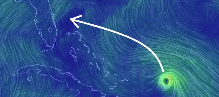
This is going to be a pretty grim update for Florida. Dorian will now move through the Bermuda Triangle over the next few days in an environment favorable for tropical development and intensification. We’re talking about warm ocean surface temperatures, low wind shear and little-to-no land obstruction aside from the flat Bahamas closer to the US. The warmer ocean temps will allow optimal latent-heat exchange to power the storm. The low wind shear will minimize disorganization of the cyclone. I’m trying to think of other variables that could hinder strengthening. Other than natural trochoidal oscillations and eye wall replacement cycles…I got nothing.
High pressure and upper-level ridging to the N of Dorian will turn its track direction from NW to WNW between tonight and tomorrow (Friday) night. Saturday and Sunday should feature a straight trajectory to the W/NW. Unfortunately this means an E FL Hurricane landfall is likely somewhere in the Sunday night to Monday afternoon period. In order to account for as much variance as possible landfall is theoretically possible between Miami, FL and Savannah, GA. However my assessment and gut are honing in on the area between Port St. Lucie, FL and Jacksonville, FL. This would put the area between Melbourne, FL and St. Augustine, FL in my gut bull’s-eye.
All of E Florida should be readying their hurricane evacuation plan. Dorian will likely produce life-threatening storm surge, flooding rainfall and destructive winds. If Dorian makes landfall in the southern half of expectations then we’re likely looking at re-emergence and re-strengthening in the Gulf of Mexico which would then threaten the NE gulf coast with another landfall. If Dorian makes landfall in the northern half of expectations then the remnant energy could curve up the SE US coast. That’s sort of where we are for expected track and curvature (as Dorian leaves the tropical tradewinds and returns to the mid-latitude westerlies).
New Jersey will obviously not be impacted by the immediate Florida landfall this ~Monday AM. But remnants could certainly slide up the coast and affect New Jersey later in the week. There is not much steering flow aloft once Dorian gets over the SE US. Therefore it could stall for quite a bit and not reach NJ until closer to the weekend. Again that’s only if landfall is more northerly within current track expectations. If the southern track expectations verify then who knows what will happen with a second landfall and further-delayed extrapolated remnants downstream. We’ll cross that bridge when it’s time.
In English: Dorian should hit E Florida in the Sunday PM to Monday PM period with Monday AM targeted for landfall somewhere between Miami, FL and Savannah, GA (widest range of possibilities). Recent observations are pointing towards the E FL area between Port St. Lucie, FL and Jacksonville, FL (starting to look this way). It’s too early to speculate Dorian’s track beyond the landfall but should it stay on the northern side of expectations (closer to Jacksonville) then remnant impacts are absolutely possible for New Jersey later next week. These would likely be in the form of downpours and moderate winds but nothing too crazy. If Dorian hits closer to Miami then New Jersey will likely avoid any influence from Dorian. At that point Dorian would re-emerge in the Gulf and likely make a second landfall.
Floridians, especially on the E coast, please use common sense and listen to your local authorities regarding evacuations and safety precautions. People of New Jersey with family and friends in Florida, please feel free to pass this along. Be safe! JC
Download the new free Weather NJ mobile app on Apple and/or Android. It’s the easiest way to never miss Weather NJ content. Our premium services go even further above and beyond at the hyper-local level. Looking for industrial-caliber long-range forecasting data that I personally recommend? Check out WeatherTrends360!
Jonathan Carr (JC) is the founder and sole operator of Weather NJ, New Jersey’s largest independent weather reporting agency. Since 2010, Jonathan has provided weather safety discussion and forecasting services for New Jersey and surrounding areas through the web and social media. Originally branded as Severe NJ Weather (before 2014), Weather NJ is proud to bring you accurate and responsible forecast discussion ahead of high-stakes weather scenarios that impact this great garden state of ours. All Weather. All New Jersey.™ Be safe! JC


LOCAL FORECAST | INTERACTIVE RADAR | LATEST NJ WEATHER ALERTS | WEDDING FORECAST| PRIVACY POLICY
© Copyright 2026 Weather NJ LLC. All Rights Reserved.
Some information that can be found on our website is provided by a private weather station and is not an officially recognized station for weather reporting. Though we always strive to achieve accurate reporting for our own use, it is important that you do NOT depend on the data provided here for any purpose.
