

Aug 3: Tropical Storm Isaias Approaching
Discussion: Isaias is a strong tropical storm located just E of the SC/GA coastal border. Sustained winds were last recorded at 70mph with higher gusts. It has a small chance for slight intensification during its last breath over warm water. Tonight Isaias should make landfall somewhere near Charleston, SC and Myrtle Beach, SC as either a strong TS or weak cat 1 hurricane. Isaias will then travel over E NC, E Virginia, E MD and Delmarva from tonight through tomorrow morning before passing over NJ tomorrow.
With land interaction I am not seeing further tropical intensification beyond the SC landfall. The system should either weaken as a tropical storm or begin unravelling as a sub-tropical storm by the time it gets to NJ. However with a fast moving system and the soupy tropical storm fuel environment that’s been in-place for NJ, we could see more of a sustained intensity rather than a quick weakening. But again, I do not see it gaining intensity over land. So it’s land interaction vs storm speed/humid environment as far as how much Isaias can weaken before passing over NJ.
Model guidance has converged certainty on timing since yesterday. This is now a tonight through Tuesday event will little-to-no spillover into Wednesday (for NJ). Even though winds and some initial outer band rainfall could start tonight, I estimate peak conditions between late-morning and early-evening tomorrow (Tuesday Aug 4). I anticipate the following conditions broken out by hazard:
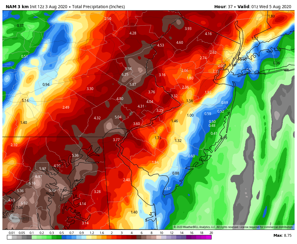
Rainfall – With the low passing either over the NJ coast or center of NJ, it puts the heaviest rainfall down for WNJ/NWNJ. I don’t think we’ll reach Irene numbers for total rainfall (which I believe was 11 inches). But I could certainly see 3-6+ inches for the jackpot swath along and NW of I-95. Areas SE of I-95 (ECNJ and SNJ) are likely looking at less rain totals (1-3 inches). Nowhere in NJ is safe from flash flooding. It will all depend on where the heaviest banding occurs. But I would favor WNJ over ENJ for it happening given the expected higher rainfall amounts. The following image is the latest rain estimate from the 18Z NAM 3K.
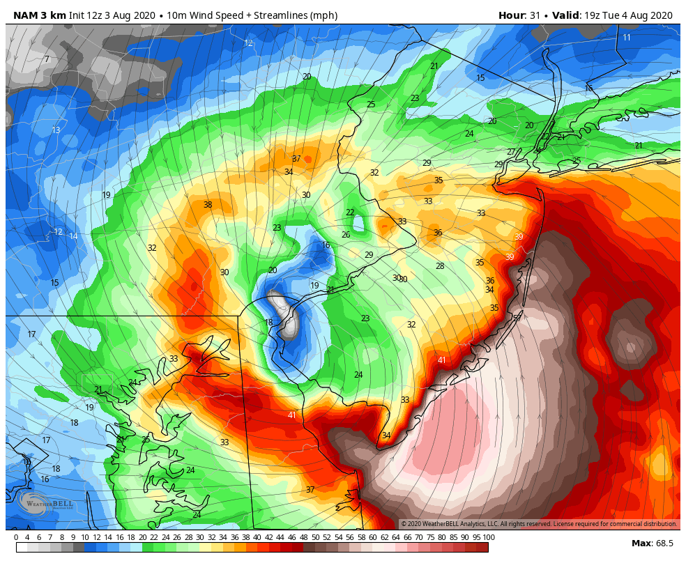
Wind – Wind should be greatest felt for the SENJ coast. Because of the two factors (faster track + soupy environment over NJ) that could sustain the strength of Isaias, we might be looking at tropical storm strength winds for ECNJ and SENJ coastal areas. For these areas gusts could exceed 60mph and possibly even get close to 70mph in isolated instances. But I do think that the common gusting scenario will be around 50-60mph. For everyone else in NJ away from the ocean, land friction will likely inhibit wind gusts to 40-50mph or so. Sustained values obviously lower. With all of this being said, wind-related power outages are a strong possibility tomorrow. Once the center of circulation passes over NJ the winds will switch from E/SE to W/NW and gradually subside through Tuesday night into Wednesday. The following image is the latest sustained wind expectation from the 18Z NAM 3K.
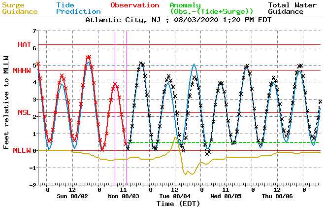
Coastal Flooding – We have a few things working on our side regarding coastal flooding. First Isaias will be passing by very quickly so there will be minimal time for multiple high tide cycles to stack up. And once Isaias passes, the winds will shift to more of a blow out tide pattern. With that said, peak onshore winds are timed with low astronomical tide tomorrow afternoon. All of this adds up to just a minor-to-moderate coastal flooding risk late-tomorrow morning/early tomorrow afternoon. The following tidal flooding guidance is from NOAA for Atlantic City, NJ (which you can generally apply to anywhere from Cape May to Monmouth County coasts.
After the storm passes through the NW flow behind the system should cool and dry at least NWNJ out with some lower temperatures and dew points. Unfortunately SENJ might see little relief from this because the Bermuda high is still cranking warmth and moisture in over Delmarva onto SENJ. We might stay that way (divided in feel – NWNJ/SENJ) for a few days before we all warm back up under another ridge.
In English: Rain and wind should begin picking up tonight/overnight, especially for SNJ/SENJ. Rain and wind conditions should intensify through tomorrow morning (Tuesday Aug 4) until reaching peak intensity between late-morning and late-afternoon. Condition should begin improving once the remnants of Isaias move away and to the N/NE of NJ by tomorrow evening. Rainfall should be heavy at times capable of producing flash flooding. Winds could be very gusty along the ECNJ/SENJ coast (60mph+). Areas away from the ocean should see some winds but nothing like the coast. Winds are capable of producing power outages. Coastal flooding should be held to minor/moderate phases. Major phase unlikely given timing of peak intensity with low tide. Places that normally see water in the streets are the most prone. The bottom line is that we’ve seen these conditions many times before whether it be a tropical storm impact or decent nor’easter. While it does not seem like a catastrophic event, please respect and appreciate the hazards that do come with heavy rainfall and high winds. I’ll check back later tonight as we should have some initial rain bands approaching. Otherwise I will likely provide one last update tomorrow morning ahead of the expected peak intensity window. Have a great rest of your Monday and please be safe! JC
Download the new free Weather NJ mobile app on Apple and/or Android. It’s the easiest way to never miss Weather NJ content. Our premium services go even further above and beyond at the hyper-local level. Looking for industrial-caliber long-range forecasting data that I personally recommend? Check out WeatherTrends360!
Jonathan Carr (JC) is the founder and sole operator of Weather NJ, New Jersey’s largest independent weather reporting agency. Since 2010, Jonathan has provided weather safety discussion and forecasting services for New Jersey and surrounding areas through the web and social media. Originally branded as Severe NJ Weather (before 2014), Weather NJ is proud to bring you accurate and responsible forecast discussion ahead of high-stakes weather scenarios that impact this great garden state of ours. All Weather. All New Jersey.™ Be safe! JC


LOCAL FORECAST | INTERACTIVE RADAR | LATEST NJ WEATHER ALERTS | WEDDING FORECAST| PRIVACY POLICY
© Copyright 2026 Weather NJ LLC. All Rights Reserved.
Some information that can be found on our website is provided by a private weather station and is not an officially recognized station for weather reporting. Though we always strive to achieve accurate reporting for our own use, it is important that you do NOT depend on the data provided here for any purpose.
