

Aug 30: Hurricane Dorian Update
Discussion: Per the latest (11AM) National Hurricane Center update Dorian is a category 2 hurricane moving NW at 10mph with a central pressure of 972mb.
With that said the storm has slowed its movement down a bit and deepened in central pressure since yesterday. The forecast for E Florida remains very poor. All upper-level hindering forces are now non-existent. I’m seeing healthy upper-level outflow which is a sign that Dorian is breathing properly. I’m seeing critical convection now wrapping around an entire defined eye. Today the eye is clearing out which further points to a strengthening tropical cyclone. I see no reason why Dorian won’t become a major hurricane today and possibly a category 4 or even 5 prior to E Florida landfall.
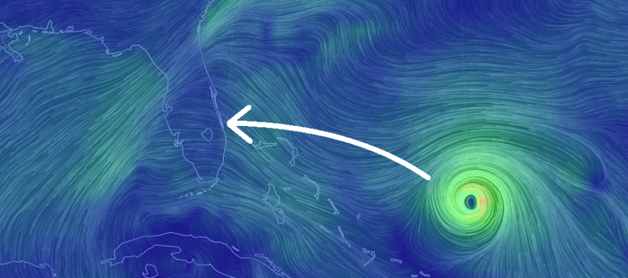
I think it’s time we start considering other points of damage aside from initial landfall. My gut feeling for initial landfall still remains in the Port St. Lucie to Jacksonville coastal area. Today I am leaning towards the southern half of that span (closer to Port St. Lucie). The problem is that after initial landfall I am starting to see the scenario where Dorian turns up the coast of Florida (towards Jacksonville). And with most of interior E Florida being everglades and hot moist swampy area we now have to consider the brown ocean effect. This is where a tropical cyclone is over land but thinks it’s still over warm water. Such an occurrence could stall or even halt weakening after impact.
The upper-level steering influences remain fairly consistent. We have a trough lifting out of the NE US and Mid-Atlantic US this weekend and another moving through next week. Interaction between these troughs and Dorian will provide some of the northward lifting mechanism. That and the weakness that forms between the ridges. The Euro is still showing stronger initial ridging which means more turning/pushing influence into southern areas of Florida (near West Palm beach). The GFS is still showing weaker ridging resulting in landfall N of Port St. Lucie. The next 24 hours will be critical in determining final track into E Florida. Again it will all come down to the ridging strength over the next 24-48 hours or so.
Beyond Florida impact I’m starting to place confidence in Dorian riding up the SE US coast towards OBX before departing into the Atlantic Ocean. This would bring dangerous surf to E NJ coastal areas and possibly some outer bands of rain and light-to-moderate winds next weekend (Sept 6-8). We have to let landfall happen first before putting any more stock into NJ impacts. But this is how it’s starting to look.
In English: The chances of Hurricane Dorian making E FL landfall as a major hurricane are significantly increasing. Landfall would start around Labor day and impacts would continue beyond. My gut for initial landfall is now the area between Port St. Lucie and Cape Canaveral. Yesterday my gut was from Port St. Lucie to Jacksonville so I have narrowed in favor of a more southern track. After landfall it looks like Dorian could ride up the entire SE US coast as a weakening tropical system before departing out to sea near OBX around next weekend. New Jersey would then see remnant impacts next weekend in the form of manageable rain, wind and coastal flooding. I’ll continue to monitor and report accordingly. Be safe! JC
Download the new free Weather NJ mobile app on Apple and/or Android. It’s the easiest way to never miss Weather NJ content. Our premium services go even further above and beyond at the hyper-local level. Looking for industrial-caliber long-range forecasting data that I personally recommend? Check out WeatherTrends360!
Jonathan Carr (JC) is the founder and sole operator of Weather NJ, New Jersey’s largest independent weather reporting agency. Since 2010, Jonathan has provided weather safety discussion and forecasting services for New Jersey and surrounding areas through the web and social media. Originally branded as Severe NJ Weather (before 2014), Weather NJ is proud to bring you accurate and responsible forecast discussion ahead of high-stakes weather scenarios that impact this great garden state of ours. All Weather. All New Jersey.™ Be safe! JC


LOCAL FORECAST | INTERACTIVE RADAR | LATEST NJ WEATHER ALERTS | WEDDING FORECAST| PRIVACY POLICY
© Copyright 2026 Weather NJ LLC. All Rights Reserved.
Some information that can be found on our website is provided by a private weather station and is not an officially recognized station for weather reporting. Though we always strive to achieve accurate reporting for our own use, it is important that you do NOT depend on the data provided here for any purpose.
