

Aug 30: NJ Labor Day Weekend Tropical Impact Now a Possibility
The system we’ve been watching for almost 2 weeks now is strengthening in the Gulf of Mexico and could impact New Jersey for the second half of Labor Day Weekend.
Because this system has remained so weak, it has managed to avoid several steering currents that otherwise would have launched the system to the N and NE by now. First was the departing high that was threatening to bring the system up over S/C Florida and out to sea by now (never happened). That has come and gone. The next major steering current is the trough moving through the Mid-Atlantic and Northeast US this week. This is what is expected to lift the system away to the NE near OBX and further into the Atlantic.
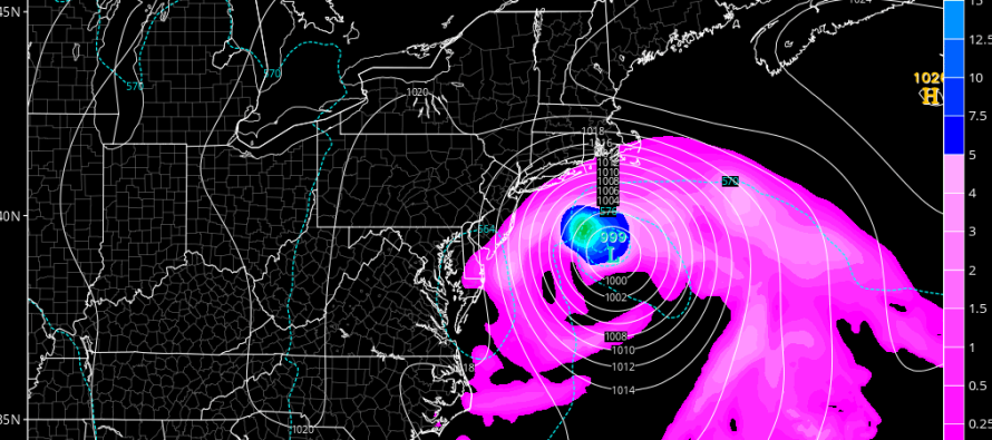
However, if the system keeps moving W in the Gulf of Mexico, even possibly a slight jog to the W/SW, then it could cross Florida/SE US later and stronger, missing the trough and stalling/retrograding into the New Jersey/NYC area. This would be during the second half of Labor Day Weekend. The GFS, Canadian, UK Met and even the Euro models are all now hinting at this and therefore we need to watch closely now.
We need to see this system first, graduate into a named storm and second, cross N Florida/SE US. At that point we will be able to see if the trough will catch it and lift it out to sea or miss it and have the return flow of high pressure take it towards our NJ/NYC area.
Up until now, the threat for the Mid-Atlantic US coast was minimal but with the recent shift in guidance reflecting the slower storm, such is becoming a much higher chance.

In English: A tropical storm, possibly hurricane, will make landfall in the NW Florida gulf coast on Thursday. Could be as far west as Pensacola. Could be just N of Tampa. That’s the spread. After that, the system is expected to cross over N Florida/SE US and re-emerge in the Atlantic Ocean. It could then ride up the east coast and turn into our area for the second half of Labor Day. I wouldn’t be doing my job if I didn’t bring this information to you. Therefore, I am NOT calling for a landfall threat as of right now. But it could get pretty darn close and at the very least, bring rough surf to the Jersey Coast! I’ll be monitoring and will have a video out tonight. Thanks and be safe! JC
Jonathan Carr (JC) is the founder and sole operator of Weather NJ, New Jersey’s largest independent weather reporting agency. Since 2010, Jonathan has provided weather safety discussion and forecasting services for New Jersey and surrounding areas through the web and social media. Originally branded as Severe NJ Weather (before 2014), Weather NJ is proud to bring you accurate and responsible forecast discussion ahead of high-stakes weather scenarios that impact this great garden state of ours. All Weather. All New Jersey.™ Be safe! JC


LOCAL FORECAST | INTERACTIVE RADAR | LATEST NJ WEATHER ALERTS | WEDDING FORECAST| PRIVACY POLICY
© Copyright 2026 Weather NJ LLC. All Rights Reserved.
Some information that can be found on our website is provided by a private weather station and is not an officially recognized station for weather reporting. Though we always strive to achieve accurate reporting for our own use, it is important that you do NOT depend on the data provided here for any purpose.
