

Aug 31: Major Hurricane Dorian Update
Discussion: Per the latest (11AM) National Hurricane Center update Dorian is a category 4 hurricane moving W at 8mph with a central pressure of 945mb.
The slowing trend continues. If you’ve been following my updates the storm was moving 13mph two days ago and 10mph yesterday. This is because Dorian entered beast mode intensification over the last 48 hours and is now close to a category 5 hurricane. I would not be surprised to see Dorian reach category 5 status by tonight or even today.
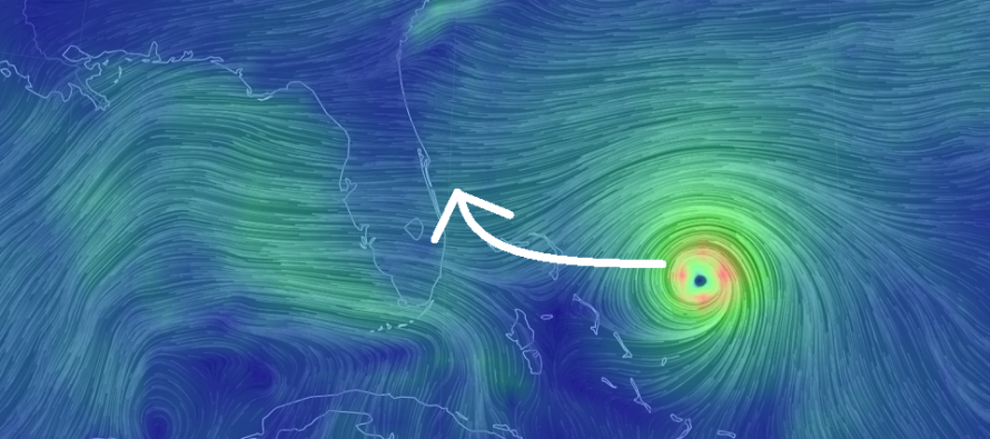
A favorable trend for Florida has emerged but an unfavorable trend for the Mid-Atlantic US has begun. The upper-level setup is allowing a weakness between ridges for Dorian to turn northward into. The first ridge was responsible for turning Dorian’s heading from N/NW to W over the last 48 hours. The European model had this ridging stronger and lasting longer than it actually has. Therefore there is less of a westward steering force which should allow Dorian to make the N turn up the coast.
Remember, tropical cyclones in the Atlantic Ocean naturally move to the W with the W-blowing trade winds that span from W Africa to the Caribbean. The mid-latitude westerlies blow towards the E. It is a tropical cyclone’s ultimate destiny to leave the trade winds and enter the westerlies. Where the tropical cyclone makes this switch is where it curves northward. In most cases that’s either into the Gulf of Mexico, into the SE US or completely staying out to sea closer to Bermuda. In this case Dorian looks to make the curve just along the SE US coast from C Florida to OBX.
This is the point where most people want to hug singular model output. The best way to handle this is to think rationally. We have a re-curving major hurricane. Slight variations could now mean a storm that either makes landfall on E Florida or stays off the coast of Florida. Obviously a landfall is more destructive locally but Florida would still not be off the hook with a slight offshore pass. There would still be tremendous storm surge, rain and less powerful winds. The cone of uncertainty still includes E Florida for a reason…variance.
So while the latest trend in model guidance has given Florida some hope for the most destructive part of Dorian, it has woken up the southern Mid-Atlantic US as landfall potential has now emerged for South Carolina or North Carolina. I’m not ready to speculate landfall location further up the US coast just yet but I am fairly confident that New Jersey is still only on the hook for secondary/fringe impacts later this coming week. Dorian will likely be steaming away to the NE by the time it hits OBX latitude.
I suspect further trending with the immediate track of Dorian as the upper-level variance is projected from model run to model run. Some call it the windshield wiper effect. Just a few days ago some model guidance had Dorian hitting Miami and going into the Gulf of Mexico. Today model guidance has the eye missing Florida completely. Sometimes the models find that sweet spot in the middle. We see it all the time with snow storms in the winter.
In English: It is becoming likely that E Florida could escape direct landfall but still endure at least tropical storm conditions with a close passing major hurricane. In other words Florida is not off the hook from storm surge, rain and wind but might be off the hook from an Andrew 92-like situation. We’ll likely know this for sure by tomorrow morning. Dorian has slowed down during it’s rapid intensification in the Bermuda Triangle which means E Florida should get the entire Labor Day Weekend in before any impacts. Now that we have moved along in time South Carolina and North Carolina should begin to take probable Dorian impacts seriously in the Wednesday-Thursday period. Beyond that Dorian still has the potential to move over the OBX area as it heads out to sea to the NE. This could absolutely bring fringe impacts to the Delmarva Peninsula and New Jersey next weekend in the form of heavy rain, periods of moderate winds and a brief period of onshore flow-related storm surge. There is still no direct threat of hurricane landfall for Delmarva or New Jersey however. I hope you are enjoying the great current NJ weather. Be safe! JC
Download the new free Weather NJ mobile app on Apple and/or Android. It’s the easiest way to never miss Weather NJ content. Our premium services go even further above and beyond at the hyper-local level. Looking for industrial-caliber long-range forecasting data that I personally recommend? Check out WeatherTrends360!
Jonathan Carr (JC) is the founder and sole operator of Weather NJ, New Jersey’s largest independent weather reporting agency. Since 2010, Jonathan has provided weather safety discussion and forecasting services for New Jersey and surrounding areas through the web and social media. Originally branded as Severe NJ Weather (before 2014), Weather NJ is proud to bring you accurate and responsible forecast discussion ahead of high-stakes weather scenarios that impact this great garden state of ours. All Weather. All New Jersey.™ Be safe! JC


LOCAL FORECAST | INTERACTIVE RADAR | LATEST NJ WEATHER ALERTS | WEDDING FORECAST| PRIVACY POLICY
© Copyright 2026 Weather NJ LLC. All Rights Reserved.
Some information that can be found on our website is provided by a private weather station and is not an officially recognized station for weather reporting. Though we always strive to achieve accurate reporting for our own use, it is important that you do NOT depend on the data provided here for any purpose.
