

Aug 4: Isaias is Here
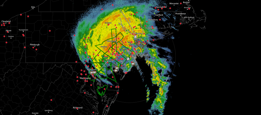
Discussion: Hope everyone is staying safe out there! The eye of Isaias remnants is currently moving from N Delaware into SWNJ. This will calm the winds for SWNJ but NNJ and CNJ will remain under gusty E winds while SENJ now experiences S winds of the former eastern eye wall. As the center of circulation moves northward up the EPA/WNJ vertical axis, the E sides of NJ will change in wind direction from E to SE to S. Areas under the eye will calm.
Once you feel winds out of the W/NW you know the center of circulation has passed your latitude. After that conditions should dry out and backside flow wind of the system should gradually subside overnight tonight as the remnants continue to pull away N/NE.
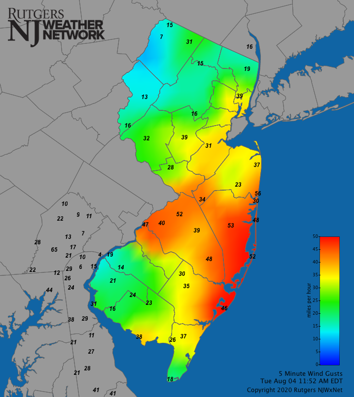
So far things are going about as expected. It’s never possible to nail mesoscale conditions when forecasting synoptically. But the overall general idea has verified. Isaias remnants have hit NJ after crossing over parts of the E Mid-Atlantic US. WNJ is dealing with more rainfall/lesser winds and ENJ is dealing with more winds/lesser rainfall. Here are the current wind gusts from the Rutgers Network. You can see where the eye wall is wrapped from SENJ to WCNJ.
We won’t know final rainfall totals until the system is out of here. But so far WNJ has seen at least a few inches of rainfall. ENJ, especially the ECNJ/SENJ coast, has see a few heavy bands but not a persistent dumping of rain like WNJ.
Coastal flooding looks like it’s holding in the minor category. The storm surge will lose it’s E flow engine soon and we are heading towards low tide (this afternoon).
There were a few tornado warnings in SENJ likely triggered by the additional friction that land generates under conflicting wind directions over different altitudes. There might even be an investigation into some of the known velocity couplet locations and reports. Tornadoes are a wildcard in the NE quadrant of tropical circulation over land.
In English: The peak conditions of Isaias NJ impacts are occurring now. Very gusty winds for ECNJ/SENJ and heavy rains for the interior. Conditions should improve from S to N between now and late-afternoon/early-evening. Everyone please be safe! JC
Download the new free Weather NJ mobile app on Apple and/or Android. It’s the easiest way to never miss Weather NJ content. Our premium services go even further above and beyond at the hyper-local level. Looking for industrial-caliber long-range forecasting data that I personally recommend? Check out WeatherTrends360!
Jonathan Carr (JC) is the founder and sole operator of Weather NJ, New Jersey’s largest independent weather reporting agency. Since 2010, Jonathan has provided weather safety discussion and forecasting services for New Jersey and surrounding areas through the web and social media. Originally branded as Severe NJ Weather (before 2014), Weather NJ is proud to bring you accurate and responsible forecast discussion ahead of high-stakes weather scenarios that impact this great garden state of ours. All Weather. All New Jersey.™ Be safe! JC


LOCAL FORECAST | INTERACTIVE RADAR | LATEST NJ WEATHER ALERTS | WEDDING FORECAST| PRIVACY POLICY
© Copyright 2026 Weather NJ LLC. All Rights Reserved.
Some information that can be found on our website is provided by a private weather station and is not an officially recognized station for weather reporting. Though we always strive to achieve accurate reporting for our own use, it is important that you do NOT depend on the data provided here for any purpose.
