

Aug 29: Heat Wave Detected!

A strong ridge of re-enforced high pressure should continue building over the E. US. This will bring above-average temperatures to the entire mid-Atlantic region for the first third-to-half of September. I’ll be releasing the long-range September outlook (powered by WeatherTrends360) soon but it’s at least safe to expect some warm weather in the next 10-15 days.
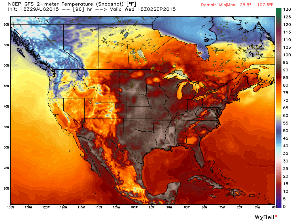
In order to meet the criteria of a heat wave, we need 3 days of 90 or greater. While I think this will happen for interior urban areas along I-95 (Philadelphia-Trenton-NYC), it might only top out in the mid-to-upper 80s for NNJ elevations and along the immediate coast. We’ll see. Regardless, it will be hazy, hot and humid during the day, especially during early-afternoon hours. Here’s the expected surface temperatures off the latest GFS for Wednesday afternoon, just one of many similar days to come (model image used with permission from WeatherBell Analytics):
Ocean surface temperatures are ranging from 72-75 along the Jersey Shore (Sandy Hook to Cape May) with back bay temperatures even warmer. This should keep coastal regions and barrier islands warmer overnight while interior regions fall below 70 due to radiational cooling (clear skies and calm winds at night) and now a longer and increasing period of darkness. This could also mean foggy conditions which I’ll be keeping an eye on each evening. Expect the NWS to issue air quality alerts as pollutants and exhaust will have trouble rising in such an overall warm environment.
Unfortunately there isn’t much rainfall expected in this period which will contribute to the building drought. No widespread rainfall, however isolated-to-scattered thunderstorms are always possible with heat and humidity so some localized areas could see relief while others do not. I’ll be watching for any defined thunderstorm threats that arise.
Stay cool and be safe! JC
Jonathan Carr (JC) is the founder and sole operator of Weather NJ, New Jersey’s largest independent weather reporting agency. Since 2010, Jonathan has provided weather safety discussion and forecasting services for New Jersey and surrounding areas through the web and social media. Originally branded as Severe NJ Weather (before 2014), Weather NJ is proud to bring you accurate and responsible forecast discussion ahead of high-stakes weather scenarios that impact this great garden state of ours. All Weather. All New Jersey.™ Be safe! JC


LOCAL FORECAST | INTERACTIVE RADAR | LATEST NJ WEATHER ALERTS | WEDDING FORECAST| PRIVACY POLICY
© Copyright 2026 Weather NJ LLC. All Rights Reserved.
Some information that can be found on our website is provided by a private weather station and is not an officially recognized station for weather reporting. Though we always strive to achieve accurate reporting for our own use, it is important that you do NOT depend on the data provided here for any purpose.
