

August 2019 WeatherTrends360 Outlook

It’s time to harness WeatherTrends360 technology and look at how the rest of July 2019 should play out. WeatherTrends360 algorithms are documented with an 84% verification rate and are based on oceanic water cycles, time table series and very complex mathematics. The best takeaway from this data are general trends (cool vs warm, rainy vs dry, etc). I’m always hesitant to forecast specific surface conditions (rainfall amounts, snowfall amounts, winds, etc) beyond the 7 -day forecasting period. But temperature and precipitation trends are what WeatherTrends360 does best with their proprietary mathematical analysis derived from over 150 years of reactive pattern data. For this reason, let’s call this a long-range discussion of reasonable expectations rather than a locked-in long-range forecast.

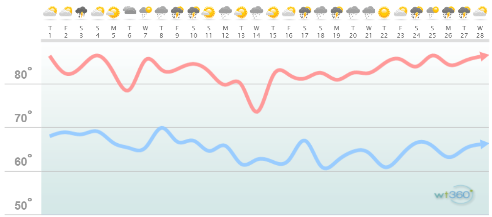
The following diagram is calculated using WeatherTrends360 proprietary algorithms for New Jersey in general. Please keep in mind that micro-climate influences can vary. NWNJ elevations and immediate coastal areas, for example, will likely verify slightly cooler than illustrated due to elevation and marine flow influence. Interior CNJ/SNJ (closer to Philly/Trenton – I-95 corridor) slightly warmer than illustrated. All areas of NJ however would have similar graph trends and sky conditions. It’s best to let the graph paint an overall picture instead of focusing on the details.
Discussion: July failed to disappoint if you like tropical humidity and flash-flooding rainfall. It’s been a pretty active storm season for 2019 so far but we’re now crossing the line into the latter part of the year’s climatology. Typically August relaxes on frequency of heat waves and thunderstorms. There are still acute instances of such but simply not as bad as May-July is. It is very common for NJ to drought in August and September especially in the absence of synoptic rain systems. This year has been anything but common though.
We’ve had a few factors keep NJ “not as hot” as it could be. The July 18-21 heat wave was the only wave where 100 was reached a few days in a row. For the most part temperatures have been capped in the 90s. We’ve had a jet stream position favorably placed for much of this. There’s been a lot of W US ridging that has led to E US troughing or a flat zonal pattern in general with the jet stream close to NJ. For these reasons we’ve also been more unsettled than usual. Again that July 18-21 period was one of the only periods this year where a ridge has been able to bake the Mid-Atlantic US with the jet way to the N.
Moving forward through August the data indicates a dominant E Pacific/W US ridging setup which would in-theory mean more troughing or flat zonal jet patterns for the E US. This would mean reasonable temperatures (near to slightly-above average) but with more unsettled conditions overall. NJ overall looks fairly dry in August but we know how much rain the slow-moving localized flash-flooding thunderstorms can dump. It’s best just to assume the existing pattern continues but maybe just a little less rain and heat than July.
It looks like we’ll have a dip or two mid-month where the days simply feel fantastic. Nights will be “ok to sleep outside.” The early taste of fall type stuff. Don’t let it fool you as August looks to currently finish warmer.

In English: Overall the month of August should feature near to slightly-above temperatures and near to slightly-above precipitation for New Jersey. Localized downpours from slow-moving thunderstorms can obviously skew this but again those instances are localized. I think we’re looking at lots of highs in the 80s statewide with lows in the 60s. The 90+ days are possible here and there but only a handful of days and more favored for interior CNJ/SNJ. The SNJ/SENJ immediate coast will stay warmer overnight (low-70s) via marine influence. Anytime this air mass is pulled into cooler and drier interior air fog is possible. I would expect the stormy pattern to continue with frontal passages every 3-6 days. Nothing going on right now tropically but I’m starting to pay attention to the setup as peak hurricane season approaches for NJ. There is currently some Saharan dust which inhibits tropical development however sea surface temperatures in hurricane highway (from Cape Verde to the east coast) are quite above-average. You’ll know about anything that constitutes a realistic threat to the Mid-Atlantic US coast. Have a great August and please be safe! JC
Jonathan Carr (JC) is the founder and sole operator of Weather NJ, New Jersey’s largest independent weather reporting agency. Since 2010, Jonathan has provided weather safety discussion and forecasting services for New Jersey and surrounding areas through the web and social media. Originally branded as Severe NJ Weather (before 2014), Weather NJ is proud to bring you accurate and responsible forecast discussion ahead of high-stakes weather scenarios that impact this great garden state of ours. All Weather. All New Jersey.™ Be safe! JC


LOCAL FORECAST | INTERACTIVE RADAR | LATEST NJ WEATHER ALERTS | WEDDING FORECAST| PRIVACY POLICY
© Copyright 2026 Weather NJ LLC. All Rights Reserved.
Some information that can be found on our website is provided by a private weather station and is not an officially recognized station for weather reporting. Though we always strive to achieve accurate reporting for our own use, it is important that you do NOT depend on the data provided here for any purpose.
