Bertha to impact Jersey Shore (Aug 5-6)

It’s peak season at the Jersey Shore. Hundreds of thousands of people are populating the barrier islands as soon-to-be Hurricane Bertha is taking shape. Expected coastal impacts are the most we will see from Bertha. This includes above-average wave heights, dangerous rip tides, and rough surf in general. While surf’s up for the pros, it’s best to observe from the beach if you’re not a seasoned ocean swimmer.
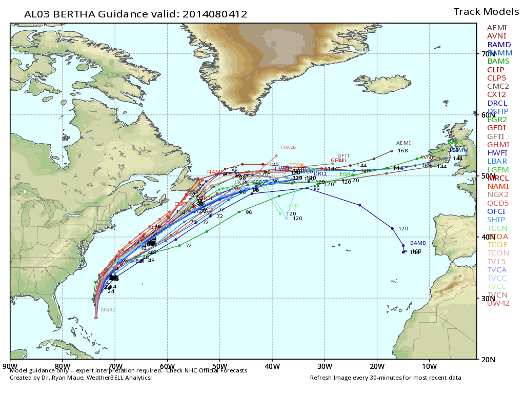
Bertha is currently a strong tropical storm that will likely upgrade to a hurricane today or tonight. It should pass between the Outer Banks of North Carolina and Bermuda before curving out to sea a few hundred miles off the Jersey Shore. It should pass by NJ on Tuesday evening-Wednesday as anything from a strong tropical storm to a category 1 hurricane. There will be little to no impacts on land from Bertha. We have other unsettled weather approaching from the west this week that will bring it’s own rain and storms. The only scenario I see possible would be the absolute outer bands of Bertha hooking up with energy over land and ringing out some additional moisture for the coast. Just a small chance of that.
There won’t be dangerous winds or tidal flooding to worry about from Bertha. Again, the extent of her impact should be coastal surf intensification. Please listen to your lifeguards. There will be skilled surfers and swimmers taking their lives into their own hands. To each is own but if your swimming skills aren’t up to par, it’s probably best to sit this one out on the beach. Here’s the latest computer model tropical spaghetti plot for expected path, courtesy of WeatherBell Analytics:

Bertha should move out by Wednesday evening. A cold front will then move in and bring back the cooler and drier weather we’ve become used to (highs in lower-80s and lows in 50s/60s). With that being said, Thursday into the weekend looks amazing. Remember that post-tropical activity blue sky and feel I referenced after Arthur? Well here it comes again. I’ll continue to track Bertha until she’s gone. Be safe! JC
Jonathan Carr (JC) is the founder and sole operator of Weather NJ, New Jersey’s largest independent weather reporting agency. Since 2010, Jonathan has provided weather safety discussion and forecasting services for New Jersey and surrounding areas through the web and social media. Originally branded as Severe NJ Weather (before 2014), Weather NJ is proud to bring you accurate and responsible forecast discussion ahead of high-stakes weather scenarios that impact this great garden state of ours. All Weather. All New Jersey.™ Be safe! JC


