

Big Changes Coming after Warmer Week
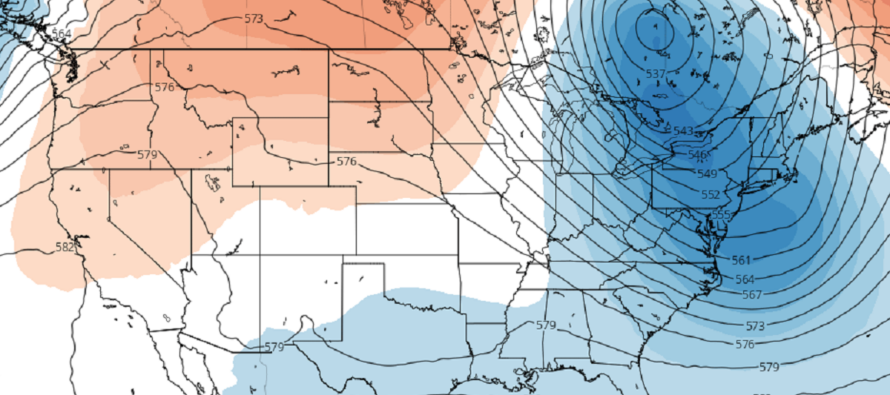
Discussion: This week, we have a solid transition from warmer to cooler conditions. The 250mb jet and 500mb height analysis indicates a well-defined ridge giving way to a deep trough. The ridge will dominate much of today through Friday with clear and warm but pleasant air mass…warm days and cool nights. We’ll then deal with a frontal rain system in the lower levels associated with the front of the trough swinging in Friday-Saturday. The frontal rain/storm potential doesn’t look too crazy but that will then usher in some pretty big changes temperature-wise. Saturday-forward and through much of the long-range indicates afternoon highs capped in the 60s with overnight lows down into the 40s. So, a warm and dry Mon-Thurs this week, a rainy transition Friday-Saturday morning, then a fall smack to the face Saturday afternoon and beyond. One might argue that local summer for coastal areas ends Thursday night. The tropics are winding down for NJ as they should in October with falling sea surface temperatures. This time of year tends to feature tropical cyclones that originate in the Caribbean rather than Cape Verde. But they will struggle to retain tropical characteristics once up at NJ latitude. Think how Sandy started as a cane but transitioned to an extra-tropical mid-latitude cyclone before landfall. With that said, the seasonal storm threat for NJ is transitioning from hurricane to nor’easter this month. There’s nothing out there right now, other than Philippe (way out – E of Bermuda expectations), but I’ll be on anything that does pop-up in October.
Monday (Oct 2) high temperatures should reach the mid-to-upper 70s for most NJ locations. A few spots away from the ocean could break 80 but humidity is low and it should feel more like a pleasant 80 not a swampy 80. Skies should be mostly sunny. Winds should be light out of the NE. Overnight lows should range from 50-60 from NNJ elevations to SNJ coasts.
Tuesday (Oct 3) high temperatures should push even warmer than Monday with many locations breaking into the lower-80s. Coastal ECNJ/SENJ regions will probably hang in the mid-70s. A warm air intrusion like this is a recipe for fog so watch out for that in the morning. Otherwise skies should be mostly sunny after the fog bakes off shortly after sun-up. Winds should be light out of the W. Overnight lows should range from 55-60 from NNJ elevations to SNJ coasts.
Wednesday (Oct 4) high temperatures should again push into the lower-80s away from the ocean while hanging in the mid-70s along coastal regions. Winds should be light out of the SE. Overnight lows should range from 50-60 from NNJ elevations to SNJ coasts.
Thursday (Oct 5) high temperatures should reach the low-to-mid 70s for most NJ locations. Skies should be mixed with more sun than clouds. Winds should be light out of the E. Overnight lows should range from 55-65 from NNJ elevations to SNJ coasts.
Friday (Oct 6) high temperatures should reach the low-to-mid 70s for most NJ locations. Skies should start mixed with increasing cloud coverage throughout the day. Periods of rainfall are possible from afternoon-forward. Not seeing much thunderstorm fuel with this front tho I suppose a few rumbles are possible near the heaviest rainfall. Probably just a rain/breeze type thing. Winds should be light-to-breezy out of the S/SE. Overnight lows should fall to the low-to-mid 60s for most of NJ as more rainfall is possible into Saturday morning.
An early look at the weekend indicates a wet start Saturday morning with conditions improving by afternoon and for the rest of the weekend. Much cooler though with highs in the 50s and lows in the 40s for many. A mid-fall feel rather than an early one. Let’s revisit in a few days. Have a great week and please be safe! JC
Premium Services
KABOOM Club offers inside info forecast discussion, your questions answered, and early storm impact maps (ahead of the public). At a buck per month, it’s an extremely feasible way to show support.
My Pocket Meteorologist (MPM), in partnership with EPAWA Weather Consulting, offers professional/commercial interests, whose businesses depend on outdoor weather conditions (snow plowing, landscaping, construction, etc.), with hyper-local text message alerts/forecasts and access to the MPM premium forum—the most comprehensive and technical forecast discussion available for PA and NJ.
Jonathan Carr (JC) is the founder and sole operator of Weather NJ, New Jersey’s largest independent weather reporting agency. Since 2010, Jonathan has provided weather safety discussion and forecasting services for New Jersey and surrounding areas through the web and social media. Originally branded as Severe NJ Weather (before 2014), Weather NJ is proud to bring you accurate and responsible forecast discussion ahead of high-stakes weather scenarios that impact this great garden state of ours. All Weather. All New Jersey.™ Be safe! JC


LOCAL FORECAST | INTERACTIVE RADAR | LATEST NJ WEATHER ALERTS | WEDDING FORECAST| PRIVACY POLICY
© Copyright 2026 Weather NJ LLC. All Rights Reserved.
Some information that can be found on our website is provided by a private weather station and is not an officially recognized station for weather reporting. Though we always strive to achieve accurate reporting for our own use, it is important that you do NOT depend on the data provided here for any purpose.
