

Blizzard Nor’easter Snowstorm Developing for New Jersey

Discussion: I’m sorry all of Jersey. But YOU ARE IN THE KABOOM ZONE NOW. This storm is going to bring heavy snowfall, gusty winds, power outages, and coastal flooding to New Jersey between Sunday (tomorrow) morning and Monday evening (Feb 22-23, 2026). A classic snowstorm.
A quick synoptic snowstorm summary before we move on to the three phases of the storm. A ridge is setting up in the W US with an ideal axis (Idaho/Montana) to force a storm trough for the E US. Multiple vorts/waves are diving into the back of the storm trough including specific polar and Pacific vorts which will turn the trough into a slightly negative tilt/axis by the time it reaches the interior E US. This will form a closed-off upper low that will throw a lasso over a coastal surface low expected to form off OBX. The UL influence will cause the coastal surface low to track close to the coast (tuck in) before pulling away. While it does this, it will throw a snowstorm precipitation shield over all of NJ and surrounding state areas, dropping major to historic snow accumulations. The coastal surface low will encounter bombogenesis and deepen into a very tight cyclonic pressure gradient causing high winds for NJ, especially the ECNJ/SENJ coastal regions. The onshore wind component will cause coastal flooding (at least minor, likely moderate, possibly major). This is the point where we can calm down with the synoptic discussion and focus more now on communication that most of the public will understand. Therefore, from this point forward, I will keep it simple and break the snowstorm down into three 12-hour phases:
In English:
Snowstorm Phase I: Sunday 6am to Sunday 6pm
This phase could feature temperature issues, especially I-95 and SE. Climatology is certainly in play and much of CNJ/SNJ will want to, at least try to, reach a Sunday high temperature of 36-42 from I-95 down to the SENJ coast. Therefore, there’s a chance that SNJ starts as rain and stays rain from about 6am to maybe 2pm on Sunday. During this time, areas NW of I-95 will start as snow. I expect to see a snow/rain line across NJ during this time (6am to 2pm Sunday). There is some disagreement as to how much warmth will happen Sunday morning. The GFS has very little rain at all with mostly just a snowstorm. The Euro and others have more. In either case, it is a temporary initial rain that might happen before the main event (Phase II). Precipitation during this initial onset however is expected to be light. Then from 2pm to 6pm on Sunday, I expect precipitation to pick up in intensity which will mean NNJ goes from light snowfall to moderate snowfall and SNJ goes from rain to moderate snowfall. Conditions should rapidly deteriorate from whatever they are from 2pm-forward Sunday. By 6pm if not earlier, all of NJ, even the tip of Cape May, should be over to snow at moderate snowfall rates. By 6pm, much of NJ (NNJ/CNJ/SWNJ) will already have snow accumulations by then but extreme SENJ will be the last to change over. Winds should be picking up at this time, especially along the ECNJ/SENJ coast. And that will conclude the first phase of the snowstorm.
Snowstorm Phase II: Sunday 6pm to Monday 6am
This is where the snowstorm will absolutely rip and crank! Temperatures will continue dropping through and after sunset as heavier precipitation brings colder air injections down from aloft. Most of NJ should level off in temps to about a 26-30 degree snowfall NWNJ to SENJ. Intense snow bands should come off the ocean into NJ from the E/SE and winds will continue intensifying, especially along the immediate coast. If there’s going to be THUNDERSNOW it will occur during this second phase Sunday night into Monday morning. Onshore winds will produce coastal flooding however with ocean temps near 35/36, the air will quickly cool to the point of minimal snowstorm accumulation impact. As the storm’s pressure drops, temperature will also drop and sustain a below-freezing temperature profile at all key layers for dendritic (snowflake) growth. Most snowfall accumulations will happen in this phase with a heavier 10:1 to 12:1 snow ratio snow. This is the worst stuff for tree branches and power lines as it causes the most amount of accumulation weight. This phase should end by 6am Monday morning when winds are no longer off the ocean and become out of the N. This is when the coastal low reaches closer to our latitude but off to our E while the snowstorm continues to dump snow on its W side.
Snowstorm Phase III: Monday 6am to Monday 6pm
Phase III will begin Monday morning when winds switch to the N. During phase II, winds will be rocking from E/NE to NE to N/NE. Once they become N, then this final phase III starts. This will be the coldest phase of the system. Snow ratios might try to climb to more of a 12:1 to 15:1 situation which will stack a little better and fluffier. At this time, the coastal battering will calm down but winds will still be elevated almost statewide out of the N and ultimately NW. This is when the final inches of accumulation will occur but at this point, many will be marveling at how much snow has already fallen from the snowstorm during phase II. This is when we’ll be watching for the back-edge of snow to end from W to E on radar. Should be one heck of a scene, Jersey! Phase III will end when the last flurries taper off from W to E across NJ. That could be anytime between noon and 6pm Monday afternoon/evening.
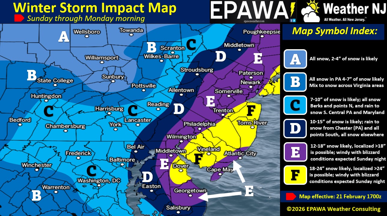
Updated Snow Map
Here is our revised and updated Feb 21, 2026 snow map after considering model data guidance and live observations over the last 24 hours. As you can see we’ve upgraded expected accumulation jackpot amounts and trimmed up the N and W extent of the precipitation a bit. Notice the extreme SENJ purple zone E area still in the slightly lower category. We did this because of the initial warmer temps and rain possible Sunday from about 6am to 2pm. This could very well not be an issue if it’s a quicker changeover from rain to snow for SENJ. In that case, that purple zone E in NJ would then behave like the F zone jackpot. However, since some of the models are still holding onto the idea of Sunday morning rain for SNJ/SENJ (everyone SE of 95 on the hook), we are allowing for slightly lower totals down there. Even then, it’s still a sizable hit once the changeover happens and the storm reaches its beast potential Sunday night into Monday morning.
I will do another YouTube video tonight. They seem to be working out well in addition to articles. Please like, subscribe and set your alerts so you never miss a video (https://www.youtube.com/@WeatherNJ)! Be safe! JC
Premium Services
KABOOM Club offers an ad-free environment, inside info (Above and Beyond) forecast discussion, your questions prioritized, and early storm impact maps and video releases (ahead of the public). At $1.99 per month, it’s an extremely feasible way to show additional support for Weather NJ and you can turn it on and off for however many months you wish. Think of it as a tip jar with perks. Available onFacebook or Patreon.
My Pocket Meteorologist (MPM), in partnership with EPAWA Weather Consulting, offers professional/commercial interests, whose businesses depend on outdoor weather conditions (snow plowing, landscaping, construction, etc.), with hyper-local text message alerts/forecasts from real meteorologists and access to the MPM premium forum—the most comprehensive and technical forecast discussion available for PA and NJ commercial interests.
KABOOM Shop is live if you want some KABOOM or Weather NJ Merch!
Sign up for ZoneWatch Radar and get 10% off
Jonathan Carr (JC) is the founder and sole operator of Weather NJ, New Jersey’s largest independent weather reporting agency. Since 2010, Jonathan has provided weather safety discussion and forecasting services for New Jersey and surrounding areas through the web and social media. Originally branded as Severe NJ Weather (before 2014), Weather NJ is proud to bring you accurate and responsible forecast discussion ahead of high-stakes weather scenarios that impact this great garden state of ours. All Weather. All New Jersey.™ Be safe! JC


LOCAL FORECAST | INTERACTIVE RADAR | LATEST NJ WEATHER ALERTS | WEDDING FORECAST| PRIVACY POLICY
© Copyright 2026 Weather NJ LLC. All Rights Reserved.
Some information that can be found on our website is provided by a private weather station and is not an officially recognized station for weather reporting. Though we always strive to achieve accurate reporting for our own use, it is important that you do NOT depend on the data provided here for any purpose.
