

Boring Week. Watching the Weekend (Jan 4-9)
Discussion: We’re just about through the lull after this morning’s precip burst. The upper-level shortwave will now interact with the surface low off the coast and fill back in precipitation. You can already see it happening in EPA. The final round should occur from late-afternoon into evening hours tonight (Sunday night). Areas along and S of I-78 more rain, some mixing possible, as expected. Areas N of I-78, especially elevations, should expect another round of wintry accumulation similar to this morning’s front end. A period of sleet will likely precede the snow. It all clears out by tomorrow morning and then we’re uneventful until Friday. By that I mean afternoon highs in the low-to-mid 40s, overnight lows in the 20s and 30s, and mostly dry. No real defining features in the atmosphere between tonight’s departing low and the approaching low on Friday. Just a period of light NW flow. Cool during the day. Colder at night. Slightly above-average overall.
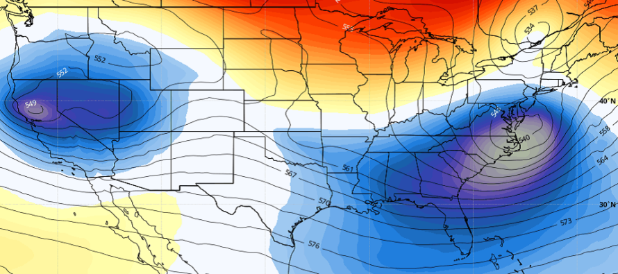
The Friday-Saturday, Jan 8-9, synoptic signal has been consistently modeled on long-range ensemble guidance. Now that we’re 5 days away from it, we’re entering the mid-range forecasting period and some surface solutions are starting to show it. The teleconnections and upper-level pattern supports it. There’s upper-level energy phasing involved. We just need to watch how it unfolds over the next few days and see how everything influences the surface low track. Currently it looks like a coastal surface low, meaning something that ejects into the Atlantic Ocean, somewhere near OBX, then hooks up towards the 40N/70W benchmark while interacting with upper-level energy (a coastal winter storm). We’ll only start to see consensus in the exact surface low track later this week. For now patience is required to see if this long-range signal continues to lean towards a go in the mid-range forecasting period.
After this Friday-Saturday, it’s logical to assume colder N/NW flow for Sunday in the wake of the departing mid-latitude cyclone. The pattern is expected to then remain alive with numerous waves of synoptic storm signals in the Jan 13-20 period. All while Polar Vortex synoptics likely work in. It could be busy times around here.
Note: Unless specifically mentioned by location (Example: NNJ elevations, SENJ immediate coast, Interior CNJ/SNJ, etc.) assume the following forecast language is statewide for New Jersey. When I say “from elevations to sea” I mean from NWNJ mountains spreading down to immediate ECNJ/SNJ coastal areas. Directions are shortened (N = North, S = South, W/SW = West/SouthWest, etc.).
Monday (Jan 4) high temperatures should reach the mid-to-upper 40s. Skies should be mostly cloudy. Winds should be light out of the N/NW. Overnight lows should range from mid-20s to mid-30s from elevations to sea.
Tuesday (Jan 5) high temperatures should reach the mid-to-upper 40s. Skies should be mixed with sun and clouds. Winds should remain light out of the N/NW. Overnight lows should range from near-20 to near-30 from elevations to sea.
Wednesday (Jan 6) high temperatures should reach near-40 for most areas. Skies should be mostly sunny. Winds should remain light out of the N/NW. Overnight lows should range from near-20 to near-30 from elevations to sea.
Thursday (Jan 7) high temperatures should reach the low-to-mid 40s. Skies should remain clear. Winds should be light out of the NW. Overnight lows should range from near-20 to near-30 from elevations to sea.
Friday-Saturday (Jan 8-9) is reserved for the tracking of a synoptic system with wintry potential. Additional details in above discussion and will be tracking daily starting tomorrow (Monday) if still a go.
Download the free Weather NJ mobile app on Apple or Android. It’s the easiest way to never miss Weather NJ content. Our premium services go even further above and beyond at the hyper-local level. Get your merch on at the KABOOM shop in time for the holidays.
Jonathan Carr (JC) is the founder and sole operator of Weather NJ, New Jersey’s largest independent weather reporting agency. Since 2010, Jonathan has provided weather safety discussion and forecasting services for New Jersey and surrounding areas through the web and social media. Originally branded as Severe NJ Weather (before 2014), Weather NJ is proud to bring you accurate and responsible forecast discussion ahead of high-stakes weather scenarios that impact this great garden state of ours. All Weather. All New Jersey.™ Be safe! JC


LOCAL FORECAST | INTERACTIVE RADAR | LATEST NJ WEATHER ALERTS | WEDDING FORECAST| PRIVACY POLICY
© Copyright 2026 Weather NJ LLC. All Rights Reserved.
Some information that can be found on our website is provided by a private weather station and is not an officially recognized station for weather reporting. Though we always strive to achieve accurate reporting for our own use, it is important that you do NOT depend on the data provided here for any purpose.

)