

Calmer and Not as Cold this Week. Watching the Weekend
Discussion: I am gaining high confidence that we won’t see the caliber of cold again, that we experienced end of January through yesterday…where highs top out at 15 and overnight lows go into the negative. This past weekend was likely the coldest we’ll get this winter and likely for the 2026 year. Perhaps January 2027 will have something to say about that but for now, we’re over the hump of the coldest part of winter IMO.
We will now experience near to slightly below average temperatures, not well-below average temperatures. Average high temps for NJ this time of year is about 40-45 NNJ to SNJ. So even though a high of 38 might feel tropical relative to recent weeks, it is still considered slightly-below average. The only period we see where temps could rise slightly above average is the Feb 17-19 period which is considered transient among the overall February-March finish of winter. With that said, we have a solid amount of winter left and we’re now approaching the statistical snowiest period of winter.
So, I see many days in the immediate future where afternoon highs will rise above freezing but overnight lows will fall below freezing. And then after this weekend, Presidents Day Weekend, sun angle will start to play an inhibiting role in daytime snow. What this does is allow a snowstorm to still accumulate and stick more easily overnight than during the day. Daytime snowfall has to fall hard and heavy after this weekend for it to stick in the afternoon. Sun angle becomes an even larger influence as we get into March. This happens every year.
If you happen to follow EPAWA (Bobby Martrich) on YouTube and caught his latest Weather Weeklies video issued this past weekend, you will be aware of the developing ENSO state and where the MJO is heading. I recommend watching but, in a nutshell, it’s not a warm pattern for NJ. The subtropical jet will become more active (more moisture) however temperatures for the northern Mid-Atlantic US (includes NJ) and Northeast US should become locked to the N of an overrunning jet pattern, meaning we will stay on the colder side. It won’t be the pipe-bursting stuff we just went through, but cold enough to support snowfall, especially overnight. The rest of the US who will be S of the overrunning jet pattern will be too warm for snow. Careful not to get caught up in another areas forecasting outlet presented as ours. We still believe that overall temperatures, to close out February and go well into March, will remain near or slightly below average for NJ outside of the transient Feb 17-19 window of above average temperatures.
This week looks dry overall with the exception of Tuesday night into Wednesday where a disturbance will pass to the N of NJ from W to E across New England. There’s a small chance that some wintry mix could graze through NNJ but nothing serious. Only typical minor safety hazard considerations for such…slow going travel rather than delays or cancellations. Anyone S of I-80 would likely be in the form of rain.
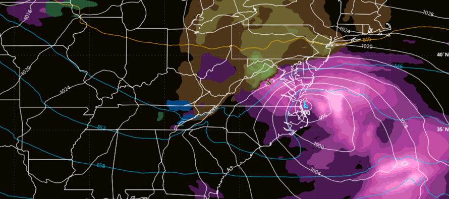
This weekend still presents a larger synoptic signal (Feb 14-16) on most model guidance but with high uncertainty. Models have been flopping all around and driving the automated forecast apps crazy. But from a pattern analysis perspective, there is support for the signal via NAO and AO behavior of spiking positive for a transient period before returning to negative. We’re going to need another few days of causal signal monitoring before we can reach some consensus on how this weekend might play out. I can tell you that it’s very possible for a snow/rain line to be involved somewhere through NJ. How far N or S that sets up will determine whether the larger Philly-NYC cities get involved with wintry or non-wintry precipitation. That is still very much yet TBD.
In English: Today (Monday) should be the last day where temperatures fail to rise above freezing. Starting tomorrow (Tuesday), temperatures should rise into the mid-30s for most of NJ and possibly lower-40s for SNJ/coastal areas. This will still technically be slightly below average but after recent times, should feel tropical lol. Some light wintry mix is possible Tuesday night into Wednesday morning, mainly for NNJ but not a big deal. Otherwise, the week is dry and “still cold, but not crazy cold.” Watching this weekend for a larger storm signal but precipitation types (snow/rain lines) are still uncertain. Feb 14-16 is the period of interest but seems to be keying in on Sunday (Feb 15). Then just after that (early next week) there should be a short 3-day period of slightly above average temperatures before we return to below-average for much of the rest of winter. A lot of winter to go with more snow chances. We are just into the 6th inning of winter for those who follow the baseball game analogy. March 1 will be the 7th inning stretch and the last week of March is the bottom or the 9th. I’ll report accordingly on the weekend storm signal as it evolves. Have a great week otherwise and please be safe! JC
Premium Services
KABOOM Club offers an ad-free environment, inside info (Above and Beyond) forecast discussion, your questions prioritized, and early storm impact maps and video releases (ahead of the public). At $1.99 per month, it’s an extremely feasible way to show additional support for Weather NJ and you can turn it on and off for however many months you wish. Think of it as a tip jar with perks. Available onFacebook or Patreon.
My Pocket Meteorologist (MPM), in partnership with EPAWA Weather Consulting, offers professional/commercial interests, whose businesses depend on outdoor weather conditions (snow plowing, landscaping, construction, etc.), with hyper-local text message alerts/forecasts from real meteorologists and access to the MPM premium forum—the most comprehensive and technical forecast discussion available for PA and NJ commercial interests.
KABOOM Shop is live if you want some KABOOM or Weather NJ Merch!
Sign up for ZoneWatch Radar and get 10% off
Jonathan Carr (JC) is the founder and sole operator of Weather NJ, New Jersey’s largest independent weather reporting agency. Since 2010, Jonathan has provided weather safety discussion and forecasting services for New Jersey and surrounding areas through the web and social media. Originally branded as Severe NJ Weather (before 2014), Weather NJ is proud to bring you accurate and responsible forecast discussion ahead of high-stakes weather scenarios that impact this great garden state of ours. All Weather. All New Jersey.™ Be safe! JC


LOCAL FORECAST | INTERACTIVE RADAR | LATEST NJ WEATHER ALERTS | WEDDING FORECAST| PRIVACY POLICY
© Copyright 2026 Weather NJ LLC. All Rights Reserved.
Some information that can be found on our website is provided by a private weather station and is not an officially recognized station for weather reporting. Though we always strive to achieve accurate reporting for our own use, it is important that you do NOT depend on the data provided here for any purpose.
