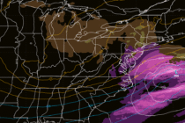
Historical Snowstorm Underway
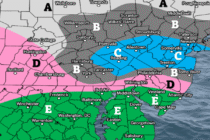
Discussion: This will be our final call snow map and forecast for this system. We’ve upgraded NNJ to now be all in the 12+ zone. That puts all of NJ in a KABOOM and still leaves Dude Where’s my Carr?


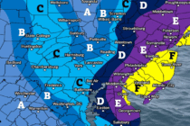
Discussion: This will be our final call snow map and forecast for this system. We’ve upgraded NNJ to now be all in the 12+ zone. That puts all of NJ in a KABOOM and still leaves Dude Where’s my Carr?

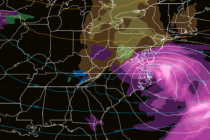
Discussion: I’m sorry all of Jersey. But YOU ARE IN THE KABOOM ZONE NOW. This storm is going to bring heavy snowfall, gusty winds, power outages, and coastal flooding to New Jersey between Sunday (tomorrow) morning and Monday evening (Feb
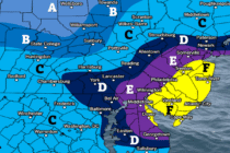
Discussion: Today we’re going to narrow the range of possible snowstorm outcomes to a first call forecast. There’s still some disagreement in snowfall amounts and timing due to disagreement in the upper levels meaning suboptimal confidence. Especially with a phase
Discussion: Some of the latest model guidance starts this snowstorm as early as 6-7am Sunday morning. That puts NJ potentially a little over 60 hours away from first flakes. The problem is that we still have a significant amount of
Discussion: Not much has changed from yesterday. We’re still 4 days away. Deep breaths. Still a lot that can happen to either reinforce a major snowstorm hit or cause an out to sea miss. I will say though, I am
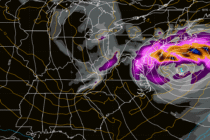
Discussion: On Friday the 13th, the signal for this weekend was identified from specific teleconnection behavior analysis, specifically the point at which the negative NAO crosses into positive and a transient spike in the PNA/dip of the EPO. This traditionally
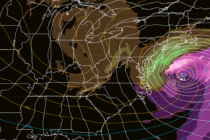
Discussion: It’s important to re-emphasize that this is not a major snowstorm. At the end of the day, it’s a weak surface low becoming a weak coastal low that’s going to clip parts of NJ with wet snow on its
Discussion: This snow potential Sunday night into early Monday morning has been beat to death for the past week+ here and especially in KABOOM Club. We identified this period as a storm signal early and have been walking it in
Discussion: This weekend outlook will be in article form as we are still watching Sunday night into Monday morning for potential wintry impacts in New Jersey. But first lets cover the period leading up to that. A trough, which brought
Discussion: I am gaining high confidence that we won’t see the caliber of cold again, that we experienced end of January through yesterday…where highs top out at 15 and overnight lows go into the negative. This past weekend was likely

LOCAL FORECAST | INTERACTIVE RADAR | LATEST NJ WEATHER ALERTS | WEDDING FORECAST| PRIVACY POLICY
© Copyright 2026 Weather NJ LLC. All Rights Reserved.
Some information that can be found on our website is provided by a private weather station and is not an officially recognized station for weather reporting. Though we always strive to achieve accurate reporting for our own use, it is important that you do NOT depend on the data provided here for any purpose.


