

Wet Snow/Rain Event Approaching
Discussion: It’s important to re-emphasize that this is not a major snowstorm. At the end of the day, it’s a weak surface low becoming a weak coastal low that’s going to clip parts of NJ with wet snow on its northern fringe side of the overall large synoptic rainstorm. Also important to re-emphasize the temperature profile for this event which is very marginal (close to freezing temps/even above freezing temps where it is going to snow). Much of NJ well into the 40s today for afternoon high temps before we fall through sunset and into the start of precipitation. We’ve gotten used to well-below freezing events at all levels (producing high snow ratios) in the last few months and this will not be that. Instead, we’re looking at 8:1 to 10:1 at most snow ratios.
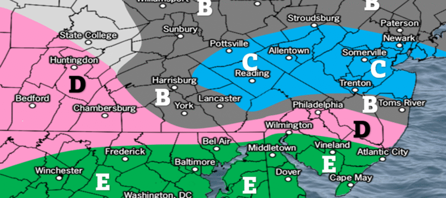
This will be overnight snowfall, however, so that mitigates the warmest part of the day (at the surface) knocking down accumulations. We do have the northern stream shortwave digging in a lot more than what was modeled earlier in the week. With all of that said, there is still an open range of outcome potential. Anything from just a slushy dusting to the wintrier 2-4/3-6 scenario IMO. Therefore, I believe that’s the minimum and maximum upside potential from this. Even in the most perfect phasing of energy outcome possible, no one would crack out of that 2-4/3-6 upper bound. Our revised snow map below is a middle ground of the potential range I mentioned which I am leaving open at this point.
We’re in a split flow pattern which will prevent a total phase of the northern stream shortwave and the upper low. The reason this system is happening is because of that northern stream shortwave digging towards a partial, not total, interaction. It lowers the geopotential heights much further N up the east coast than the UL would have by itself. This allows the lifting and precipitation shield to expand northward into NJ latitude while also mixing in the cold from the northern stream shortwave. This is what takes us from “too warm for snow” down to “marginally supportive of wet snow accumulation.”
Snow will not accumulate evenly across all surfaces. As I said yesterday, 3-6 inches of snow could fall out of the sky. 1-3 could stick to natural surfaces, and a coating to an inch could stick to untreated roads and only to the N of the snow/rain line setup. I hope there’s not too much confusion with this idea but this is what happens with wet heavy snow, compaction, etc. in a marginal temperature environment. Different than when we’re well-below freezing at all levels and every inch that falls sticks.
As far as the general snow/rain line is concerned, we are tightening up our jackpot area with today’s final call. We feel the wintriest potential will occur between I-80 down to I-195 with I-78 right in the middle of that horizontal band through NJ. Areas S of I-195 we expect to see the most amount of rain before any changeovers happen from a southward-advancing snow/rain line. If you extend the Mason-Dixon line across SNJ, that general area and all of SNJ below that, will likely see rain only. N Burlington and N Ocean are probably the most uncertain areas in this regard and could go either way (stay mostly rain or change to a finishing snow burst). We expect a gradual taper through NNJ, especially N of I-80. The latest data is really targeting between I-195 and I-78 for the most wet snow from this.
Timing has been relatively consistent. We expect rain to start out across SNJ around 4-7pm this evening with NNJ/CNJ delayed an hour or two on the start. NNJ/some of CNJ would likely start wintry and stay wintry. The snow/rain line would then advance slowly from CNJ into northern SNJ from about 7pm to midnight-ish tonight. All precipitation is expected to wrap up between about 1-3am overnight (Monday morning) from W to E.
Here is our revised and final snow map heading into the event:
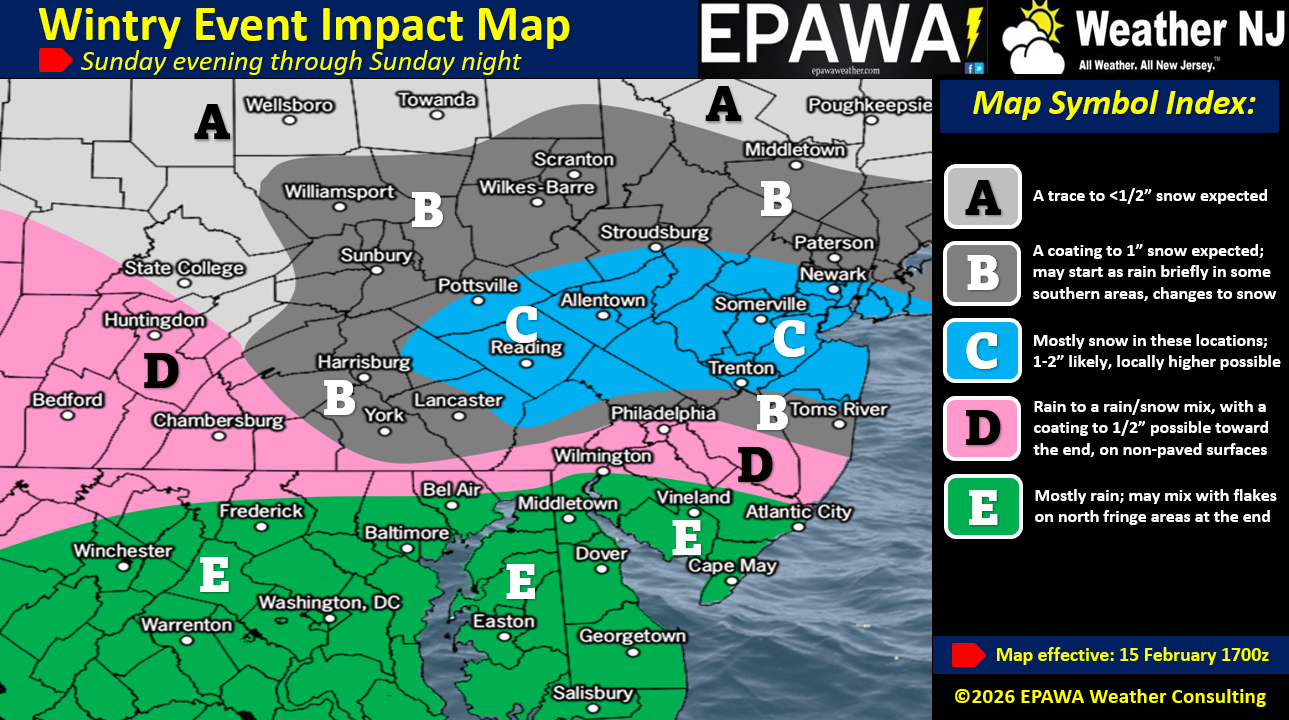
In English: The northern side of a weak storm is going to graze NJ with some wet heavy snow and rain this evening into early tomorrow morning. NNJ/CNJ will likely see the most wet snow and SNJ likely the most rain. Our wintry impact map above illustrates the middle-of-the-road approach to expected snow accumulations and rainfall. However, we are leaving the door open on either side as wildcards meaning it could be more of a slushier widespread C-1 kind of thing or possibly a 2-4/3-6 event in the case of higher performance. For this reason we use language like “locally higher possible” in our legends. Our map represents what we feel is the most reasonable and realistic public communication. Precipitation starts around 5-7pm for SNJ (NNJ by 8/9pm) this evening and then falls until about 1-3am Monday morning. Live observations will begin on first flakes this evening. Be safe! JC
Premium Services
KABOOM Club offers an ad-free environment, inside info (Above and Beyond) forecast discussion, your questions prioritized, and early storm impact maps and video releases (ahead of the public). At $1.99 per month, it’s an extremely feasible way to show additional support for Weather NJ and you can turn it on and off for however many months you wish. Think of it as a tip jar with perks. Available onFacebook or Patreon.
My Pocket Meteorologist (MPM), in partnership with EPAWA Weather Consulting, offers professional/commercial interests, whose businesses depend on outdoor weather conditions (snow plowing, landscaping, construction, etc.), with hyper-local text message alerts/forecasts from real meteorologists and access to the MPM premium forum—the most comprehensive and technical forecast discussion available for PA and NJ commercial interests.
KABOOM Shop is live if you want some KABOOM or Weather NJ Merch!
Sign up for ZoneWatch Radar and get 10% off
Jonathan Carr (JC) is the founder and sole operator of Weather NJ, New Jersey’s largest independent weather reporting agency. Since 2010, Jonathan has provided weather safety discussion and forecasting services for New Jersey and surrounding areas through the web and social media. Originally branded as Severe NJ Weather (before 2014), Weather NJ is proud to bring you accurate and responsible forecast discussion ahead of high-stakes weather scenarios that impact this great garden state of ours. All Weather. All New Jersey.™ Be safe! JC


LOCAL FORECAST | INTERACTIVE RADAR | LATEST NJ WEATHER ALERTS | WEDDING FORECAST| PRIVACY POLICY
© Copyright 2026 Weather NJ LLC. All Rights Reserved.
Some information that can be found on our website is provided by a private weather station and is not an officially recognized station for weather reporting. Though we always strive to achieve accurate reporting for our own use, it is important that you do NOT depend on the data provided here for any purpose.
