

Coastal Concerns (Nov 15-17)
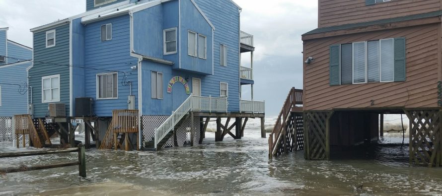
Discussion: The upper-level cut-off low that was stalled over the Baja Peninsula is tracking across the S US from W to E. It will merge with a northern stream shortwave and produce a strong synoptic rainstorm for the SE US and S Mid-Atlantic US. Most rainfall should just miss NJ to the SE aside from some outer-band sprinkles possible. The bigger story is the persistent onshore flow which will be assisted by the high pressure tracking to our N (also from W to E). This should set up at least minor coastal flooding for Saturday and possibly moderate to low-end major coastal flooding for Sunday into Monday. By Monday the flow should switch from E/NE to N/NE and the coastal flooding threat should subside. With that said the SENJ coastlines should see most impacts from the storm that will be out to sea. Everyone else in NJ should see little-to-no impacts. NWNJ should be sunnier and calmer while SENJ is cloudier and windier with coastal concerns.
Friday (Nov 15) high temperatures should reach near-50 for most areas. Skies should range from mostly sunny to mostly cloudy NNJ to SNJ. Winds should be light out of the W. Overnight lows should range from mid-20s to mid-30s NNJ to SNJ.
Saturday (Nov 16) high temperatures should range from mid-30s to mid-40s NNJ to SNJ. Skies should be mixed with sun and clouds. A little cloudier for SNJ/SENJ. Winds should be breezy out of the N/NE. Minor coastal flooding is possible for SENJ coastlines. Overnight lows should range from lower-20s to upper-30s NNJ to SNJ.
Sunday (Nov 17) high temperatures should range from upper-30s to upper-40s. Skies should vary. Sunnier and calmer for NNJ. Cloudier and windier for SNJ/SENJ (wind gusts to 35mph possible). Minor-to-moderate coastal flooding is likely with a small chance of low-end major especially for extreme SENJ. Can’t rule out a few sprinkles for SENJ from the ocean low. Overnight lows should range from near-30 to near-40 NNJ to SNJ.
An early look at next week indicates temperatures near average and a synoptic rain signal for the Tuesday-Wednesday period. As of right now it looks too warm for snow but I’ll be following over the weekend in case more cold air can be pulled into the system. Have a great weekend and please be safe! JC
Download the new free Weather NJ mobile app on Apple and/or Android. It’s the easiest way to never miss Weather NJ content. Our premium services go even further above and beyond at the hyper-local level. Looking for industrial-caliber long-range forecasting data that I personally recommend? Check out WeatherTrends360!
Jonathan Carr (JC) is the founder and sole operator of Weather NJ, New Jersey’s largest independent weather reporting agency. Since 2010, Jonathan has provided weather safety discussion and forecasting services for New Jersey and surrounding areas through the web and social media. Originally branded as Severe NJ Weather (before 2014), Weather NJ is proud to bring you accurate and responsible forecast discussion ahead of high-stakes weather scenarios that impact this great garden state of ours. All Weather. All New Jersey.™ Be safe! JC


LOCAL FORECAST | INTERACTIVE RADAR | LATEST NJ WEATHER ALERTS | WEDDING FORECAST| PRIVACY POLICY
© Copyright 2026 Weather NJ LLC. All Rights Reserved.
Some information that can be found on our website is provided by a private weather station and is not an officially recognized station for weather reporting. Though we always strive to achieve accurate reporting for our own use, it is important that you do NOT depend on the data provided here for any purpose.

)