

Coastal Storm Approaching
Discussion: I wanted to discuss tonight’s coastal storm in more detail as it deserves its own article.
In the upper levels we have an approaching negative-tilted trough. This 1) provides the cold air and 2) provides upper dynamics to intensify the surface coastal low. The surface coastal low will track northward mainly along the Jersey coast overnight, just ahead of the trough in the greatest area of positive vorticity advection.
While you’re still N of the low, winds will be off the ocean (out of the E or E/SE). When the low is directly over you, you should experience a lull in winds. When the low gets N of you, winds will pick back up but out of the W or W/NW. This goes for all of NJ except for NWNJ.
NWNJ is subject to more of a NE wind and generally colder conditions, especially the higher elevations of Sussex County. For these reasons, Sussex is looking at possible hard sloppy snowfall overnight. It’s hard to tell how much will accumulate on the roads but it will be sloppy. Climatology this time of year along with the warmer flow off the ocean will do its job to keep it sloppy.
For the rest of NJ (S of I-80/SE of I-287), this is a rain and wind storm. Things get interesting on the opposite end of the state in SENJ. The peak onshore wind-driven storm surge tonight will time poorly with high astronomical tide. And since this coastal storm is tracking right along the coast, rather than offshore, the onshore wind direction will align closer to inlet/Del Bay orientation. For these reasons, minor-to-moderate coastal flooding is likely for the SNJ/ENJ coasts, including SWNJ coasts.
Here’s our snow map. Snow interests are likely limited to Sussex County and points N and W of such. Like I said above, this is a rain and wind storm for most of NJ with sloppy snow possible in NWNJ and coastal flooding likely in SENJ.
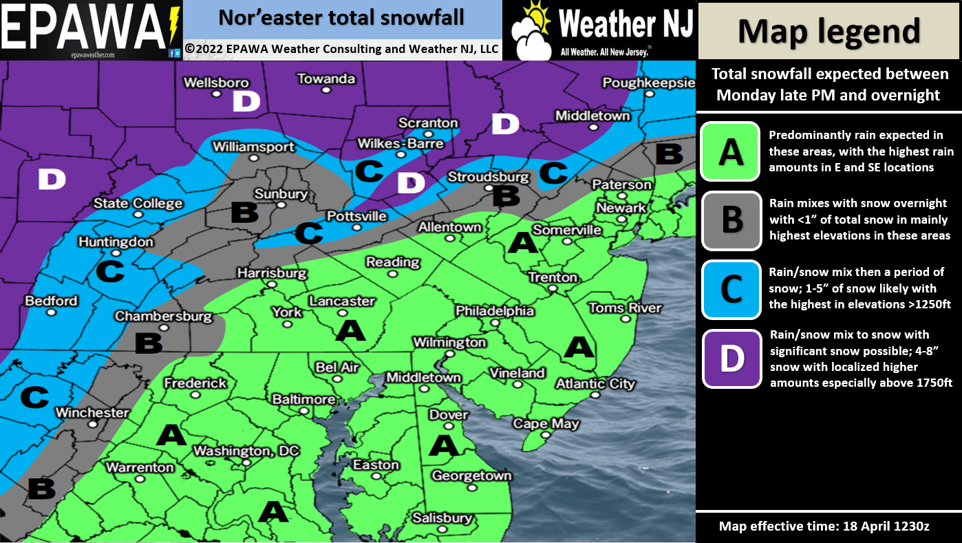
In English: Rainfall should pickup from now into overnight hours. 1-2 inches of rain are expected to fall between now and early tomorrow morning. Winds should intensify this evening and peak around midnight. Immediate coastal areas should feel the strongest winds (sustained 15-25mph with gusts to 45mph). Areas away from the coast should see slightly lesser winds. Sussex County is the most favored for a very wet and sloppy snow job. The rest of NJ will see a cold rain, but simply not cold enough for snow. Watch for minor-to-moderate coastal flooding along the SENJ/ECNJ coast tonight. Everything should clear by daybreak tomorrow with W/NW winds tapering. I’ll be checking in with radar obs posts from here. Have a great night and please be safe! JC
Premium Services
KABOOM Club is more for the snow lover or weather nerd who needs inside info with early forecast discussion and storm impact maps (ahead of the public). It’s a bit more complex than what the public sees but offers the “In English” with it. It’s also a way to support Weather NJ with a 99-cent per month contribution.
My Pocket Meteorologist offers commercial interests, whose businesses depend on outdoor weather conditions (snow plowing, landscaping, construction, etc.), with hyper-local text message forecasts and access to the My Pocket Meteorologist premium forum. This information is the most complex analysis available as needed by the outdoor commercial sector.
Jonathan Carr (JC) is the founder and sole operator of Weather NJ, New Jersey’s largest independent weather reporting agency. Since 2010, Jonathan has provided weather safety discussion and forecasting services for New Jersey and surrounding areas through the web and social media. Originally branded as Severe NJ Weather (before 2014), Weather NJ is proud to bring you accurate and responsible forecast discussion ahead of high-stakes weather scenarios that impact this great garden state of ours. All Weather. All New Jersey.™ Be safe! JC


LOCAL FORECAST | INTERACTIVE RADAR | LATEST NJ WEATHER ALERTS | WEDDING FORECAST| PRIVACY POLICY
© Copyright 2025 Weather NJ LLC. All Rights Reserved.
Some information that can be found on our website is provided by a private weather station and is not an officially recognized station for weather reporting. Though we always strive to achieve accurate reporting for our own use, it is important that you do NOT depend on the data provided here for any purpose.
