

Coastal Storm Departs
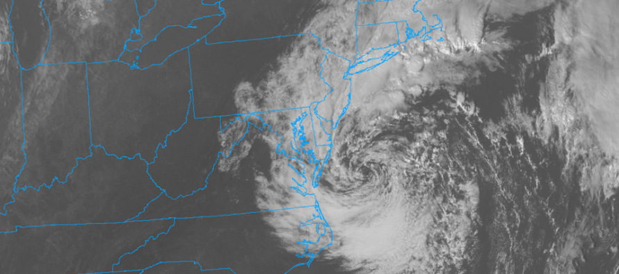
Discussion: The upper low that got caught beneath the ridge for the past few days is finally starting to pull away. This will place the western side of the cyclonic steering flow from the upper low over the surface low and send it out to sea to the S/SE. The reason the coastal surface low meandered in place for so long is because it got stuck in the inner wall of the upper low steering and merry-go-rounded around towards NJ, then towards Delmarva. Now the coastal low will slingshot out to the S/SE like a NASA spacecraft using a planet’s gravitational field to do the same.
Winds have subsided, even along the coast, and rainfall has become even more scattered/isolated across the Mid-Atlantic US. A few isolated pockets of light rain remain to our W and N but are expected to fizzle out in the next 3-6 hours or so. The only area I’m still watching is NENJ in case the Long Island rain and thunderstorms make it over and wraparound down onto NENJ. Some areas might even see that strange thing we call the sun later today before sunset. I think it was Friday when I last saw it. It might even set up a vivid sunset this evening if the back edge of clouds can time right. Coastal flooding is no longer an issue. Goodbye coastal low (the last remnants of Ian). It’s been fun (not really) but you can go now.
The next noteworthy feature is a dry cold front expected to push through New Jersey, from NW to SE, on Friday PM. But from now until then, we’ll remain in a stale but mild air mass. Another low is positioned to our N in Canada and should drive a warm sector into the NE US for the next 36-48 hours. This should produce a mild and dry (mixed sun and clouds) Thursday and Friday with surface temperatures possibly breaking 70 both days. With dew points in the 40s/50s, you might want to bottle that feeling this late in the year.
On Friday evening, the cold front should push through, reinforced by high pressure diving S out of Canada into the Midwest US. At this point, I expect milder temps to surge Friday afternoon then drop through sunset/overnight hours. Saturday and Sunday then (behind the cold front passage) look very average for October. Most importantly clear, dry, and sunny with very low dew points (30s/40s). We’re talking about afternoon highs in the upper-50s/lower-60s and overnight lows in the upper-30s/lower-40s. A gorgeous fall weekend by most standards.
In English: The coastal storm is finally moving out. All remnant isolated showers should end by sunset this evening for most. Watching some action on Long Island that might wrap into NENJ later but we’ll see. Tonight through at least Sunday then looks dry. Tomorrow (Thursday) and Friday look mild with highs possibly reaching the 70s for many. Temps should then drop Friday night into Saturday with a mostly dry cold front pushing through the region. Saturday and Sunday should then be cool, crisp, and clear with very low humidity. Might not make it to 60 for some…might dip into the 30s type stuff. As I said in the discussion a gorgeous October fall weekend by most standards.
Premium Services
KABOOM Club offers inside info forecast discussion, your questions answered, and early storm impact maps (ahead of the public). At a buck per month, it’s an extremely feasible way to show support.
My Pocket Meteorologist (MPM), in partnership with EPAWA Weather Consulting, offers professional/commercial interests, whose businesses depend on outdoor weather conditions (snow plowing, landscaping, construction, etc.), with hyper-local text message alerts/forecasts and access to the MPM premium forum—the most comprehensive and technical forecast discussion available for PA and NJ.
Jonathan Carr (JC) is the founder and sole operator of Weather NJ, New Jersey’s largest independent weather reporting agency. Since 2010, Jonathan has provided weather safety discussion and forecasting services for New Jersey and surrounding areas through the web and social media. Originally branded as Severe NJ Weather (before 2014), Weather NJ is proud to bring you accurate and responsible forecast discussion ahead of high-stakes weather scenarios that impact this great garden state of ours. All Weather. All New Jersey.™ Be safe! JC


LOCAL FORECAST | INTERACTIVE RADAR | LATEST NJ WEATHER ALERTS | WEDDING FORECAST| PRIVACY POLICY
© Copyright 2026 Weather NJ LLC. All Rights Reserved.
Some information that can be found on our website is provided by a private weather station and is not an officially recognized station for weather reporting. Though we always strive to achieve accurate reporting for our own use, it is important that you do NOT depend on the data provided here for any purpose.
