

Coastal Storm Detected
Discussion: A coastal storm will develop and impact parts of New Jersey later this weekend, mainly areas along and SE of the I-95 corridor with rain and wind. An Upper-Level Low (ULL) will break off from a very positive-tilted Midwest US trough this evening and then close-off sometime tomorrow (Friday) near/over E TX/LA. The ULL will then float across the SE US from W to E between Saturday and Sunday. How high (in east coast latitude) the ULL gets before moving into the ocean will determine the NW extent of precipitation into EPA and NNJ Sunday night into Monday. It’s the upper level steering currents that ultimately power a surface low’s track. So the further N the ULL is, the closer to the coast the surface low will track. All activity should move offshore and out by mid-Monday.
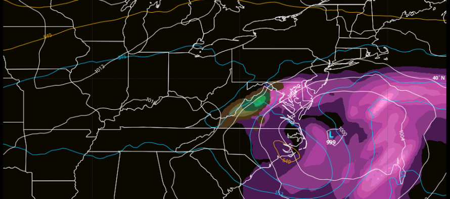
Normally this would be an ideal track for a winter storm (from OBX to the 40N/70W benchmark). There are a few reasons why this system will mostly, if not totally, lack the cold needed to produce wintry precipitation.
First, 500mb geopotential height analysis indicates an overall higher field with most of the central and eastern US above 540dam at the time preceding, time of, and time after the storm…an overall flat ridge setup with most cold well to the N. The 540dam or lower value is not always, but usually an indicator for sufficient cold aloft to support chilling down the lower-levels surface via dynamic cooling to support snow. There is some upper-level cold that stays with the ULL but it erodes away by the time it gets closer to NJ. The existing setup might produce snow for NW GA through VA earlier Sunday but likely just cold rain for NJ with all heights above 540dam Sunday night into Monday.
Second, the ULL is allowed to spin cyclonically as it moves with/under the flat ridge from W to E. However, the ULL doesn’t receive any additional cyclonic energy from behind (like an additional shortwave) nor does it encounter a ridge in front of it. This prevents the overall ULL envelope from tilting negative (what would be needed to pull the surface low in for a bigger NJ hit). Therefore, the ULL moves across the SE US from W to E with a near-neutral tilt…further allowing the surface low to stay further offshore.
Third, even if the ULL stayed cold and tracked closer to NJ, the baroclinic boundary layer will be above 32 for most areas. This is mainly due to lack of true cold air mass but also because we’re starting to fight climatology for mid-Feb. So even if the upper cold were to be there and mix to the low-mid levels via dynamic cooling, it would still fight a marginal surface temp environment to achieve stickage. The only argument I can find for colder air at the baroclinic boundary layer is the coldest annual Atlantic Ocean surface temperatures (currently in the upper-30s) pushing in via onshore flow. This means that the atmosphere would have to work less to chill the air from 38F to 32F than say 45F+ to 32F. But I still don’t think it will be enough. Daytime maximum temps through the weekend are expected to be well into the 40s. This would only apply to Sunday night into Monday morning during overnight low temps.
How could this storm perform colder? There are a few meso conditions that could align just right. The low-mid levels could feature a few pocket layers of below-freezing air. This could possibly change some rain to sleet, especially in areas of heavy precipitation. And then sleet can cool the column which could bring the surface down a bit. Also, high pressure to the N of the system could trickle in some cold air to the outermost (northernmost) area of the precipitations shield. If the precip shield is further N/W, then this could come into play. In either case, I’m thinking sleet/mixed precip though, not a complete changeover to all snow/accumulating snow. We would need to see big upper-level changes (negative tilt, energy injection from backside, ridge development ahead of storm, etc.) to make this an accumulating snow event. At this point I’m just not seeing that.
So, we’re looking at a coastal storm with cold rain and moderate wind between Sunday PM and mid-Monday. A very frustrating cold rain for the snow lover…probably in the 34-38F range. It looks like at least I-95 and SE will get in on the main synoptic rain bands. How much the precipitation cut-off advances to the NW beyond I-95 is still a bit uncertain and again, dependent on the ULL/surface low trajectory. As far as wind goes, coastal NJ will be under the influence of stiff onshore flow from Sunday afternoon through Monday morning. It will start out of the E and then slowly shift to the NE ultimately settling out of the N once the low moves away. No reason why gusts of 40mph+ can’t be felt along the ECNJ/SENJ coasts. Area away from the ocean will see lesser wind values. This should produce at least a minor coastal flooding concern Sunday night into Monday morning. But otherwise that’s it, a cold rain and wind coastal storm in February.
In English: The rest of today (Thursday) and tomorrow (Friday) should remain dry and mild with temps well into the 50s maybe even flirting with 60 in some spots. Saturday will turn slightly colder after an overnight cold front but remain dry with mixed skies. Saturday highs should reach mid-40s before falling below freezing statewide Saturday night into Sunday. Sunday should gradually increase in cloud coverage as highs reach the mid-to-upper 40s and winds begin picking up. By Sunday night rain should start pushing in off the ocean as overnight temperatures fall to a very painful mid-to-upper 30s range. Winds will crank off the ocean (40mph+ for ECNJ/SENJ coasts – lesser inland) and a minor coastal flooding threat will occur. There could be some power outages that occur mainly along the immediate coastal areas seeing the higher winds. Rain should make it to the 95 corridor but could push further into EPA/NNJ. I’ll have a better handle on that in the next few days. Then everything clears out by mid-Monday. Most precipitation from this coastal storm should be plain cold rain for most of New Jersey. However, some sleet/mixing is possible through EPA/NWNJ if conditions line up just right. Even in the coldest version of this system though, we will likely not see accumulating wintry precipitation. I’ll revisit this tomorrow for any trends or changes.
Many are asking, “is that it? A mostly snowless winter?” You know what I always say. It’s like a baseball game dividing into innings spanning from the winter solstice to the spring equinox. Right now we’re almost through the 5th inning with the 6th looking very mild. Could the E US atmosphere snap back to a colder pattern for end of February into March? Yes, it absolutely could. It could also stay mild as heck like it’s been. Every 7-10 day forecasting period is a new chance to stay the same or change. I realize that most snow lovers like their snow to fall between Christmas and President’s Day. I’m the same way. But more than a few back-loaded winters have occurred in recent times and therefore I think it’s silly to give up on an entire winter this soon. It’s leaving the baseball game way too early even though your team is down.
Have a great rest of your Thursday and please be safe! JC
Premium Services
KABOOM Club offers inside info forecast discussion, your questions answered, and early storm impact maps (ahead of the public). At 99 cents per month, it’s an extremely feasible way to show support.
My Pocket Meteorologist (MPM), in partnership with EPAWA Weather Consulting, offers professional/commercial interests, whose businesses depend on outdoor weather conditions (snow plowing, landscaping, construction, etc.), with hyper-local text message alerts/forecasts and access to the MPM premium forum—the most comprehensive and technical forecast discussion available for PA and NJ.
Jonathan Carr (JC) is the founder and sole operator of Weather NJ, New Jersey’s largest independent weather reporting agency. Since 2010, Jonathan has provided weather safety discussion and forecasting services for New Jersey and surrounding areas through the web and social media. Originally branded as Severe NJ Weather (before 2014), Weather NJ is proud to bring you accurate and responsible forecast discussion ahead of high-stakes weather scenarios that impact this great garden state of ours. All Weather. All New Jersey.™ Be safe! JC


LOCAL FORECAST | INTERACTIVE RADAR | LATEST NJ WEATHER ALERTS | WEDDING FORECAST| PRIVACY POLICY
© Copyright 2026 Weather NJ LLC. All Rights Reserved.
Some information that can be found on our website is provided by a private weather station and is not an officially recognized station for weather reporting. Though we always strive to achieve accurate reporting for our own use, it is important that you do NOT depend on the data provided here for any purpose.
