

Coastal Storm Developing for Sunday Night
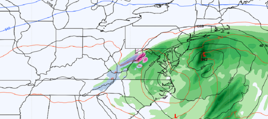
Discussion: In the next 12 hours or so, the Upper-Level Low (ULL) should close off over E TX and begin moving towards the S Mid-Atlantic/SE US area. There’s already convection firing in the N Gulf of Mexico which will enhance into a surface low once the ULL gets closer. The surface low should form about 24 hours from now (by Saturday afternoon) somewhere near the Florida panhandle. The low should then take a traditional Miller-A track to the NE, ejecting into the Atlantic Ocean over OBX and ultimately passing near the benchmark, between Saturday PM and Monday AM. Sadly the general environment lacks enough cold for this to be a winter snow storm. Instead, this storm will move through a very warm air mass (for this time of year) and bring mostly rain and wind to New Jersey between Sunday afternoon and Monday morning. Let’s discuss by hazard:
Rain: Rainfall could begin as early as late-Sunday morning but likely by afternoon for SNJ. It will then spread N and W into more of NJ between Sunday afternoon and evening hours. The precipitation shield should reach it’s maximum extent late Sunday night/early Monday morning and then gradually pull away by late-Monday morning (Monday afternoon at the latest). SENJ should see the highest rain amounts (up to 2 inches maybe higher locally). Rainfall amounts will lessen as you head away from SENJ towards the I-95 corridor. I am still uncertain if the rain will push NW of 95 or stop somewhere near 95. Either way, rainfall amounts will taper to nothing as you move NW. Only the NW-most area of the precipitation shield would have a chance to see mixed wintry precipitation at times. It doesn’t look like much though outside of some sleet. Any sleet/wintry aspects of the system will have to be called in real-time otherwise expect rain for most of the night. Sunday and Monday will eventually make it into the 40s during daytime peak afternoon hours. But most of the rainfall will occur during dark hours (Sunday night into Monday morning) when temps drop into the mid-to-upper 30s…key takeaway above 32F. Only on the NW side of the precip shield, if precip rates are high enough, will enough low-mid level cold be allowed to spill down to the surface to produce a wintry outcome. Possible but not probable.
Wind: Winds should start picking up for SNJ Sunday evening, probably during the Super Bowl. They should then crank from late-Sunday night through mid-to-late Monday morning. The winds will be most felt along the SENJ coast and felt lesser away from the ocean. Most winds should stay S and E of I-95. I wouldn’t be surprised to see wind gusts of 40-50mph along the immediate SENJ coast with the low now expected to drop to a pressure of near 990mb.Winds will first for SNJ/SENJ out of the E Sunday afternoon. Then as rain pushes further into NJ later Sunday, the winds will shift to NE. As the low gets more to the E of NJ Monday morning, winds will become N/NE then N then eventually N/NW as the system pulls away (after rain ends).
Coastal Flooding: This applies to immediate coastal areas of ECNJ/SENJ who are normally prone to saltwater flooding. This includes beaches, inlets, bays, creeks, and estuaries. We have a half moon (waning) so astronomical tides are on our side. We will, however, deal with a routine storm surge (from onshore winds) coupled with draining rainfall. With that said, there should be minor levels of coastal flooding. I’m not yet prepared to say moderate levels. It’s a quick mover. The high tides to watch will be late Sunday night, near-noon Monday, and then late Monday night. Everything should drop off and drain by Tuesday AM.
In English: I hope you enjoyed the mild weather yesterday and today. Sort of an early taste of spring. Maybe just a tongue-dart. A cold front has moved through so we’ll get colder tonight but then warm tomorrow morning. A coastal storm is developing in the south-central US and will track near NJ this Sunday PM into Monday AM. Normally (this time of year) this would be a snowstorm but the E US is overall very warm for this setup. Therefore we’ll deal with rain and wind (mostly along and SE of I-95) impacting SENJ the most. There’s a small possibility that precip could push a little NW of 95 and possibly mix at times but any sort of wintry accumulation is unlikely. It all pulls away by noonish Monday and then we’re back to unseasonably mild for next week with only a few Hail-Mary thread the needle chances of snow through about Feb 22. There are some stratospheric signals that indicate a colder end of Feb and March. Will process cautiously as we move forward. Have a great rest of your Friday and please be safe! JC
Premium Services
KABOOM Club offers inside info forecast discussion, your questions answered, and early storm impact maps (ahead of the public). At 99 cents per month, it’s an extremely feasible way to show support.
My Pocket Meteorologist (MPM), in partnership with EPAWA Weather Consulting, offers professional/commercial interests, whose businesses depend on outdoor weather conditions (snow plowing, landscaping, construction, etc.), with hyper-local text message alerts/forecasts and access to the MPM premium forum—the most comprehensive and technical forecast discussion available for PA and NJ.
Jonathan Carr (JC) is the founder and sole operator of Weather NJ, New Jersey’s largest independent weather reporting agency. Since 2010, Jonathan has provided weather safety discussion and forecasting services for New Jersey and surrounding areas through the web and social media. Originally branded as Severe NJ Weather (before 2014), Weather NJ is proud to bring you accurate and responsible forecast discussion ahead of high-stakes weather scenarios that impact this great garden state of ours. All Weather. All New Jersey.™ Be safe! JC


LOCAL FORECAST | INTERACTIVE RADAR | LATEST NJ WEATHER ALERTS | WEDDING FORECAST| PRIVACY POLICY
© Copyright 2025 Weather NJ LLC. All Rights Reserved.
Some information that can be found on our website is provided by a private weather station and is not an officially recognized station for weather reporting. Though we always strive to achieve accurate reporting for our own use, it is important that you do NOT depend on the data provided here for any purpose.
