

Coastal Storm Intensifying for New Jersey
Discussion: I’m seeing some intense coastal flooding images coming in from locations like LBI, Brigantine, etc. It’s not good considering high tide is approaching and these new rain bands will have nowhere to drain. It looks like there will be three final high tides of concern for the areas currently flooding along ECNJ/SENJ coasts.
The first is almost here today (Monday) and should peak for back bay areas around 3-5pm. The next tide of concern is tonight (early tomorrow AM) however this is the lower of the two astronomical tides so in theory, tonight shouldn’t be as bad as today’s. The third is tomorrow (Tuesday) afternoon which should be higher like todays. While the tidal flooding should start subsiding Tuesday night into Wednesday, the W-facing coasts of barrier islands should anticipate another round of flooding from all the tidewater and rainfall draining out of estuaries, creeks, and back bays towards the inlets. We saw this occurrence in the January 2016 coastal blizzard. But by Wednesday night/Thursday morning all areas should be clear of coastal flooding.
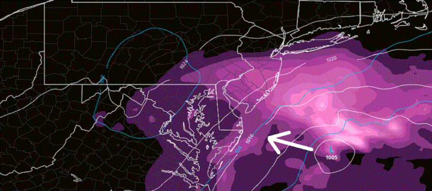
Now let’s talk about the storm. After all of Ian’s chaos through the Caribbean, W Cuba, W FL, SC, and much of the interior SE US, we finally have a singular surface low under a singular upper low that has occluded off the upper-jet off the east coast. In other words, we have the ingredients on the table for coastal storm intensification. The low is currently about 150-200 miles E of S Delmarva with a central intensity reading of 1006mb. The low is now modeled to track closer to Delmarva…about 50-75 miles E of C Delmarva between now and early Tuesday AM with intensity dropping to maybe 1002-1004mb. This will bring the core wind walls around the low closer into ECNJ/SENJ. Add some intense rain bands, like those currently coming off the ocean from the SE, and tonight’s high tide could be as bad as this afternoon’s and tomorrow afternoon’s. Then from tomorrow morning into tomorrow night the system should slowly pull away while still keeping NJ within rain and wind impact. Either way, the next 12-18 hours or so should be the most intense the coastal redevelopment gets.
From there (tomorrow evening) into Wednesday, we should see winds change from onshore to northerly which should begin the previously mentioned tidal recession. Not sure how much of the coastal storm will be left by daybreak Wednesday morning but Wednesday still looks like a day of transition into a milder and sunnier experience. Thursday and Friday still look mild (70s) with a great feel after all this current stuff. A Friday PM cold front (mostly dry) should then set up a beautiful crisp and clear weekend (highs in the 60s lows in the 40s on average).
In English: Expect rain and wind to continue today and tomorrow, especially SE of NJTP/95. NWNJ/NNJ will remain the least impacted by all of this. The coastal storm should take a close pass at the Jersey shore tonight (sitting just off Delmarva) which could mean the windiest onshore conditions the ECNJ/SENJ coast sees yet. Power outages are a good possibility. Coastal flooding remains the highest impact from this system for ECNJ/SENJ immediate coastlines. Expect another 2-3 high tides of concern between now and Wednesday morning. This will be over on Wednesday, just hang in there the rest of today and tomorrow. For most of NJ away from the ocean this is really run-of-mill nuisance stuff. For those along the immediate coast, this was probably more coastal flooding than expected. Be safe! JC
Premium Services
KABOOM Club offers inside info forecast discussion, your questions answered, and early storm impact maps (ahead of the public). At a buck per month, it’s an extremely feasible way to show support.
My Pocket Meteorologist (MPM), in partnership with EPAWA Weather Consulting, offers professional/commercial interests, whose businesses depend on outdoor weather conditions (snow plowing, landscaping, construction, etc.), with hyper-local text message alerts/forecasts and access to the MPM premium forum—the most comprehensive and technical forecast discussion available for PA and NJ.
Jonathan Carr (JC) is the founder and sole operator of Weather NJ, New Jersey’s largest independent weather reporting agency. Since 2010, Jonathan has provided weather safety discussion and forecasting services for New Jersey and surrounding areas through the web and social media. Originally branded as Severe NJ Weather (before 2014), Weather NJ is proud to bring you accurate and responsible forecast discussion ahead of high-stakes weather scenarios that impact this great garden state of ours. All Weather. All New Jersey.™ Be safe! JC


LOCAL FORECAST | INTERACTIVE RADAR | LATEST NJ WEATHER ALERTS | WEDDING FORECAST| PRIVACY POLICY
© Copyright 2026 Weather NJ LLC. All Rights Reserved.
Some information that can be found on our website is provided by a private weather station and is not an officially recognized station for weather reporting. Though we always strive to achieve accurate reporting for our own use, it is important that you do NOT depend on the data provided here for any purpose.
