

Cold Unsettled Start. Good Stuff on the Way!

Discussion: We remain in a volatile temperature pattern meaning interchangeable transient periods of milder temps and colder temps. But the cold is on hospice. This current cold that moved in yesterday will only be around today (Monday). Tomorrow (Tuesday), we will begin to warm through the remaining component of this quick 1-2 punch of a weak system.
With that said, we have the initial component approaching extreme SNJ from the W. The precip is moving along an axis running W/NW to E/SE and is currently fighting high pressure stationed over NY State/NNJ. This is going to try and squash the precip to the S of NJ today however some extreme SNJ locations could see some passing snow showers capable of dropping anything from a coating to an inch at the absolute most through this afternoon/evening. Not even map-worthy in our opinion. Temperatures are marginal and it’s the warmest part of the day. So, it is likely not a big deal. Cape May has the best chance to see it but Cumberland and Atlantic are also on the hook, I don’t see anything more than flurries reaching Salem, maybe SE Burlington and S Ocean. Temps fall to just below freezing tonight (Monday night) and then begin warming Tuesday.
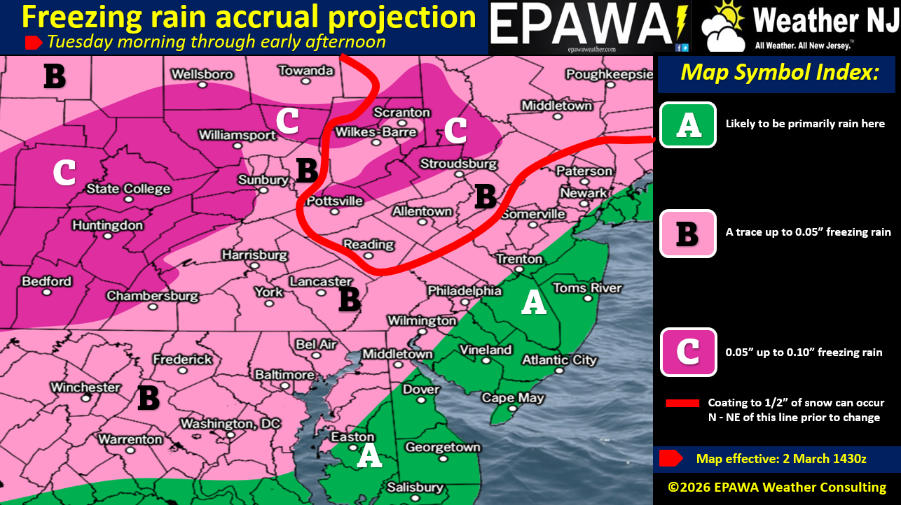
The next component occurs tomorrow (Tuesday) and although it could sort of blend in on the back of the first SNJ component today, we are treating it as its own mini disturbance. So tomorrow (on Tuesday) the high will be offshore providing return flow (out of the S). This is what will begin warming the low-mid layers of the atmosphere first (SNJ first, NNJ last). The surface will then warm SNJ to NNJ as well throughout the rest of Tuesday. SNJ should be well into the 40s by Tuesday afternoon. Although some areas could start out as snow, we do not see snow accumulation becoming a big deal. Perhaps some of NNJ/NWNJ could see a coating to an inch at most before changing to freezing rain. With the warm air advection involved, a more reasonable and realistic expectation is rain SE of I-95/NJTP and snow to freezing rain to rain NW of I-95/NJTP. Basically, all areas eventually go over to rain by Tuesday evening and we continue to warm the rest of this week. Here’s a minor impact map for Tuesday (tomorrow). Areas N and/or NW of the red line have the best chance to see a trace-light snow accumulation before the changeover:
For Wednesday-Thursday (March 4-5) we will return to temperatures more average which are well above freezing. Wednesday looks like the drier day. Thursday morning into Friday morning should feature more rain but a milder rain (in the 50s). Because clouds could be slow to clear on Friday daytime, temps might only get up to the 50s on Friday. Saturday would then start the period where highs in the 60s, possibly breaking 70, will occur. We expect this warmer period to be between Saturday March 7 and Thursday March 12. Temperature would then return closer to average for Friday, March 13-forward as we look for any abnormal cold periods to close out March. It’s too far away to see any of that now but with the action in the Polar Vortex region, it’s not off the table and why we have to give snow season until the end of March.
In English: Snow is possible across extreme SNJ today with little-to-no accumulation because of temps very close to freezing. A coating to an inch, mainly on natural surfaces seems like the realistic range of expectations for Cape May and possibly some of Cumberland/Salem/Atlantic/etc. Then on Tuesday, temps warm S to N as more precipitation moves through but for all of NJ. This could start as snow for some NNJ/CNJ areas but will change to freezing rain and then plain rain for all of NJ. Little-to-no snow accumulation nor ice accrual is expected but it could slick things up for travel safety concerns (see above map). We’re then milder and gloomy Wed-Fri (March 4-6) with some more rain possible (no wintry concerns). Wed looks drier than Thurs-Fri. Temps then shift into another gear of warmth Friday night into Saturday morning (watch out for fog) and we’ll then be well above average Saturday March 7-12. Whether or not we see snow again in the second half of March is yet TBD but it certainly won’t be the first half with how mild it’s about to get this weekend through late next week. Have a great week and please be safe! JC
Premium Services
KABOOM Club offers an ad-free environment, inside info (Above and Beyond) forecast discussion, your questions prioritized, and early storm impact maps and video releases (ahead of the public). At $1.99 per month, it’s an extremely feasible way to show additional support for Weather NJ and you can turn it on and off for however many months you wish. Think of it as a tip jar with perks. Available onFacebook or Patreon.
My Pocket Meteorologist (MPM), in partnership with EPAWA Weather Consulting, offers professional/commercial interests, whose businesses depend on outdoor weather conditions (snow plowing, landscaping, construction, etc.), with hyper-local text message alerts/forecasts from real meteorologists and access to the MPM premium forum—the most comprehensive and technical forecast discussion available for PA and NJ commercial interests.
KABOOM Shop is live if you want some KABOOM or Weather NJ Merch!
Jonathan Carr (JC) is the founder and sole operator of Weather NJ, New Jersey’s largest independent weather reporting agency. Since 2010, Jonathan has provided weather safety discussion and forecasting services for New Jersey and surrounding areas through the web and social media. Originally branded as Severe NJ Weather (before 2014), Weather NJ is proud to bring you accurate and responsible forecast discussion ahead of high-stakes weather scenarios that impact this great garden state of ours. All Weather. All New Jersey.™ Be safe! JC


LOCAL FORECAST | INTERACTIVE RADAR | LATEST NJ WEATHER ALERTS | WEDDING FORECAST| PRIVACY POLICY
© Copyright 2026 Weather NJ LLC. All Rights Reserved.
Some information that can be found on our website is provided by a private weather station and is not an officially recognized station for weather reporting. Though we always strive to achieve accurate reporting for our own use, it is important that you do NOT depend on the data provided here for any purpose.
