

Colder and Drier behind Tonight’s Rain

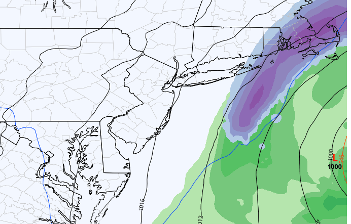
Discussion: First let’s talk about tonight. Temps should hold on the milder side and fail to dip below 45 or so. The primary low will generally track along/just NW of the Appalachian Mountains across parts of SE Ohio, W PA, and NY State between now (Thursday afternoon) and Friday afternoon. This should whiten up the E Great lakes but bring rain to all areas SE of such. Most rain for NJ will fall late tonight (Thursday night) through Friday morning and likely as a thinner strip of rain than you would think (like a thunderstorm line). You might see enough convection for boomers with it. But again, that’ll be overnight tonight and likely before Friday morning’s rush hour. The rest of the weekend is colder, breezier, and dry as N/NW winds move in behind the departing primary low. NJ wasn’t that far from a coastal snow storm this weekend. There’s now strong support for a secondary low to occlude off the boundary and develop just out to sea Sunday. As you can see on the below European model, NJ would be about 200-250 miles W of a cold conveyor belt (CCB)-driven snow band.
Looking down the road, we’re in for more above-average temperatures. There are no signs of a wintry pattern returning until about ~Jan 24 at the earliest. We might see some transient cold shots behind events that bring rain or miss (the thread the needle failures) but the milder snow lover’s drought will likely continue until at least then. NAO and AO tellies are expected to go negative around that time frame which will try to back and block up the jet stream from Greenland-upstream. But we’ll still need the E Pacific/W US area (EPO/PNA region) to cooperate with a W US ridge to bring anything snowstorm-wise to fruition on the east coast. That’s what I’ll be looking at over the next few weeks and will report accordingly. For this weekend, we have a rain event tonight into tomorrow and a few cold and dry days after (a transient cold shot) until we return to the milder pattern next week.
Friday (Jan 13) high temperatures should reach the mid-to-upper 50s. Rain should end by mid-to-late morning with improving conditions by afternoon. Winds should be breezy at times out of the W. Overnight lows should fall to near-30 for most areas as winds become NW.
Saturday (Jan 14) high temperatures should max in the upper-30s for most areas. Skies should be mixed with sun and clouds. Winds should be breezy out of the N/NW. Overnight lows should fall into the 20s statewide.
Sunday (Jan 15) high temperatures should reach near-40 for most areas. Skies should be mostly sunny. Winds should relax some out of the N/NW but still light-to-breezy at times. Overnight lows should range from teens to 20s from elevations to coasts.
An early look at next week indicates milder (for January) temps returning. 40s/50s during the day and 20s/30s at night. There are a few long-range indicators and signals for a more wintry pattern returning in the last week of January. But from now until then we’ll probably stay in a snow lover’s drought as above-average temperatures continue outside of a few transient cold shots behind missed/rainstorms. It is what it is. Have a great weekend and please be safe! JC
Premium Services
KABOOM Club offers inside info forecast discussion, your questions answered, and early storm impact maps (ahead of the public). At a buck per month, it’s an extremely feasible way to show support.
My Pocket Meteorologist (MPM), in partnership with EPAWA Weather Consulting, offers professional/commercial interests, whose businesses depend on outdoor weather conditions (snow plowing, landscaping, construction, etc.), with hyper-local text message alerts/forecasts and access to the MPM premium forum—the most comprehensive and technical forecast discussion available for PA and NJ.
Jonathan Carr (JC) is the founder and sole operator of Weather NJ, New Jersey’s largest independent weather reporting agency. Since 2010, Jonathan has provided weather safety discussion and forecasting services for New Jersey and surrounding areas through the web and social media. Originally branded as Severe NJ Weather (before 2014), Weather NJ is proud to bring you accurate and responsible forecast discussion ahead of high-stakes weather scenarios that impact this great garden state of ours. All Weather. All New Jersey.™ Be safe! JC


LOCAL FORECAST | INTERACTIVE RADAR | LATEST NJ WEATHER ALERTS | WEDDING FORECAST| PRIVACY POLICY
© Copyright 2025 Weather NJ LLC. All Rights Reserved.
Some information that can be found on our website is provided by a private weather station and is not an officially recognized station for weather reporting. Though we always strive to achieve accurate reporting for our own use, it is important that you do NOT depend on the data provided here for any purpose.
