

Colder Conditions. Ends Wintry for NWNJ.
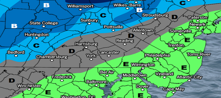
Discussion: A cold front passed through today but prior to peak afternoon solar heating. That allowed most of NJ to rise into the 40s even near-50. Temperatures and humidity will drop with sundown this evening and yield a colder Friday night with most down into the 28-35 range (from NW to SE). The breezy W/NW-turning NW winds will make it feel a bit colder. Saturday looks cold but clear. Saturday night will take advantage of radiational cooling via lighter winds and clear skies under cold aloft. Most should drop into the 20s maybe some teens. On Sunday we’ll warm up to the 40s as clouds move in ahead of what we’re calling storm 1 (Sunday night into Monday morning). Storm 1 has a well-supported consensus on data and live observations now to only produce wintry precip for NWNJ, mainly elevations. The snow/rain line should stay N of I-70/NW of I-287. And it’s probably more like N of I-80/NW of I-287. Places like High Point Monument in Sussex will likely squeeze the most snow out of this. The snow/rain line should then push N, changing most areas who started as snow, over to rain by Monday morning. Here’s our initial impact map for precipitation starting Sunday afternoon and ending Monday:
Click here to see full-resolution impact map!
Monday into Tuesday then looks colder as winds become NW behind the cold front and pull down some Canadian air mass (non-Arctic). Some moderation by Wednesday which leads us into storm 2 (Wed night into Thursday). Storm 2 currently looks similar to storm 1. Rain along and SE of 95. Maybe a snow thump to rain NW of 95. We still have some time on that but it currently looks weak and warm. Jan 26-forward then looks colder as some Arctic air returns to the scene from the other side of the N Hemisphere. It likely won’t be a brutal Arctic outbreak but colder than the stale Canadian air mass we’ve been seeing. I’m just not seeing anything that indicates a major snowstorm on my comfort zone horizon which is about the 7-10 day window. Just storm 1 (Sunday night into Monday morning) and storm 2 (Wednesday night into Thursday morning)…both warm for the lower 2/3 of NJ with light wintry mixed precip for NWNJ.
Friday (Jan 20) high temperatures are currently (Friday afternoon) maxing in the mid-to-upper 40s. Can’t rule out an isolated sprinkle but otherwise skies are mostly clear with a few flat-bottom friendlies around. It’s a little breezy out of the W/NW and that should continue overnight as temps bottom out in the low-to-mid 30s for most, maybe upper-20s for NWNJ elevations.
Saturday (Jan 21) high temperatures should reach near-40 for most. A colder day with mixed sun and clouds. Winds should subside around daybreak and become lighter out of the NW. Overnight lows should fall into the mid-to-upper 20s for most areas.
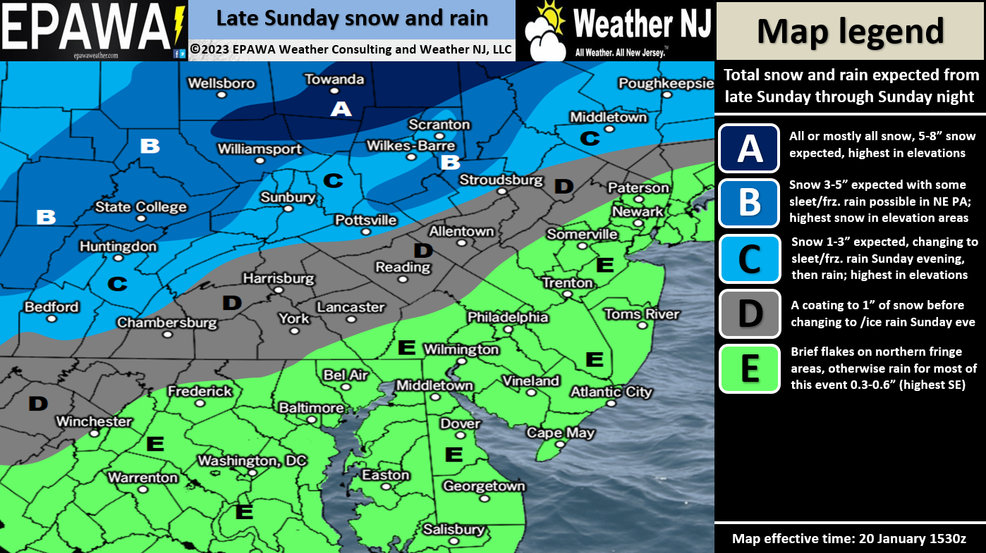
Sunday (Jan 22) high temperatures should push into the 40s during the day with increasing cloud coverage. Winds should be light-to-breezy out of the S. Rain should move in during afternoon hours and spread through NJ overnight. NWNJ, primarily elevations, are subject to a coating to a few inches of light snow. The rest of NJ should expect a cold rain.
An early look at next week indicates milder temps (for January – highs in the 40s/lows in the upper-20s/30s) coming to an end Wednesday. Thursday and beyond looks more typical of January (highs in the 30s lows in the teens/20s). Another storm system will make the transition (Wed night into Thursday) but it currently looks like a warmer system for many prior to a cold front passage. Maybe initial snow thump for NWNJ/NNJ areas. Jan 26 then opens the colder period but it’s yet TBD if any storm systems can take advantage. Everyone have a great weekend and please be safe! JC
Premium Services
KABOOM Club offers inside info forecast discussion, your questions answered, and early storm impact maps (ahead of the public). At a buck per month, it’s an extremely feasible way to show support.
My Pocket Meteorologist (MPM), in partnership with EPAWA Weather Consulting, offers professional/commercial interests, whose businesses depend on outdoor weather conditions (snow plowing, landscaping, construction, etc.), with hyper-local text message alerts/forecasts and access to the MPM premium forum—the most comprehensive and technical forecast discussion available for PA and NJ.
Jonathan Carr (JC) is the founder and sole operator of Weather NJ, New Jersey’s largest independent weather reporting agency. Since 2010, Jonathan has provided weather safety discussion and forecasting services for New Jersey and surrounding areas through the web and social media. Originally branded as Severe NJ Weather (before 2014), Weather NJ is proud to bring you accurate and responsible forecast discussion ahead of high-stakes weather scenarios that impact this great garden state of ours. All Weather. All New Jersey.™ Be safe! JC


LOCAL FORECAST | INTERACTIVE RADAR | LATEST NJ WEATHER ALERTS | WEDDING FORECAST| PRIVACY POLICY
© Copyright 2025 Weather NJ LLC. All Rights Reserved.
Some information that can be found on our website is provided by a private weather station and is not an officially recognized station for weather reporting. Though we always strive to achieve accurate reporting for our own use, it is important that you do NOT depend on the data provided here for any purpose.
