

Complicated Forecast (Sept 3-6)
Discussion: Conditions should improve behind the thunderstorms tonight. Overnight temperatures and dew points should fall a bit and produce that classic “back to school” chill-feeling in the morning. Temps and humidity should then gradually build Tuesday into Wednesday with possibly a stormy cold front pushing through Wednesday night into Thursday. Then all eyes are on whatever Dorian’s condition will be on Friday as it passes to the SE of NJ.
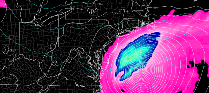
Dorian Update: Dorian is nearly stationary over the island of Grand Bahama. Short-range model guidance is almost unanimous on Dorian’s eye staying just off the coast of Florida tomorrow (Tuesday) and Wednesday as it curves northward. This is still a very lousy situation for Port St. Lucie, FL and coastal FL points north of such. Cape Canaveral jets out the furthest to the east and therefore has the best chance to see the highest wind values. If the eye wall replacement cycle completes on Dorian’s journey from Grand Bahama towards Florida then the most destructive part of the hurricane (western eye wall winds) is still possibly in play for the immediate E FL coast. Any wobble W at this point is a very bad wobble. Otherwise the central and northern E FL coast would likely just see strong tropical storm/weak hurricane-force winds. Regardless the storm surge should be very impressive just to the N of Dorian as it moves northward along the coast. This goes for Georgia, South Carolina and North Carolina as well with another landfall possible Thursday between Myrtle Beach and OBX. On Friday NJ should experience the fringe impacts of Dorian passing to the SE. How close Dorian passes will depend mostly on a trough interaction/capture (currently coming in off the Pacific Ocean into the NW US). As of right now I am thinking SENJ storm intensity should range from a weak-to-strong nor’easter. Winds could be pretty crazy along the immediate Delmarva and SENJ coast if we have a passing 969mb extra-tropically transitioning cyclone close enough. Rainfall and coastal flooding will likely be run-of-mill conditions we see a few times per year. The further away from the ocean and to the NW you are in NJ…the less chance of rain and wind you have. Once this clears out by Friday night then likely the best weather of the year is expected through Saturday and possibly into part of Sunday. Dorian should take all the moisture (humidity) away with it as drier N flow ensues behind it.
Tuesday (Sept 3) high temperatures should reach near-80 for most areas with interior CNJ/SNJ possibly reaching the mid-80s. Skies should be mostly sunny. Winds should be light out of the E. Overnight lows should range from near-60 to near-70 NNJ to SNJ.
Wednesday (Sept 4) high temperatures should reach into the 80s for most. Interior CNJ/SNJ might even flirt with breaking 90. Skies should be partly-to-mostly sunny and humid with showers and thunderstorms around especially during PM hours. Winds should be light out of the S/SW. Overnight lows should range from lower-50s to upper-60s NNJ to SNJ behind the stormy cold front.
Thursday (Sept 5) high temperatures should reach the low-to-mid 70s. Skies should be mixed with sunny periods and times of overcast. Winds should be light-to-breezy out of the E/NE. Overnight lows should range from mid-50s to mid-60s NNJ to SNJ.
Friday (Sept 6) high temperatures should reach near ocean temperatures (upper-70s) given the likelihood of onshore flow associated with Dorian passing to the SE of NJ. SENJ has a much better chance of seeing rain and wind than NWNJ. See above discussion for more details.
An early look at the weekend indicates absolutely beautiful conditions for Sturday. Sunday could return to warm and humid conditions. Let’s see how it looks in a few days. Have a great rest of your week and please be safe! JC
Download the new free Weather NJ mobile app on Apple and/or Android. It’s the easiest way to never miss Weather NJ content. Our premium services go even further above and beyond at the hyperlocal level. Looking for industrial-caliber long-range forecasting data that I personally recommend? Check out WeatherTrends360!
Jonathan Carr (JC) is the founder and sole operator of Weather NJ, New Jersey’s largest independent weather reporting agency. Since 2010, Jonathan has provided weather safety discussion and forecasting services for New Jersey and surrounding areas through the web and social media. Originally branded as Severe NJ Weather (before 2014), Weather NJ is proud to bring you accurate and responsible forecast discussion ahead of high-stakes weather scenarios that impact this great garden state of ours. All Weather. All New Jersey.™ Be safe! JC


LOCAL FORECAST | INTERACTIVE RADAR | LATEST NJ WEATHER ALERTS | WEDDING FORECAST| PRIVACY POLICY
© Copyright 2025 Weather NJ LLC. All Rights Reserved.
Some information that can be found on our website is provided by a private weather station and is not an officially recognized station for weather reporting. Though we always strive to achieve accurate reporting for our own use, it is important that you do NOT depend on the data provided here for any purpose.

)