

Conversational Snow Still Possible
Discussion: What was once modeled as a 6-12” event across EPA and NWNJ (5 days ago) has evolved into not much at all. First it trended colder and further S into CNJ and SNJ. But now it’s looking mostly like just conversational snowfall (flurries with a possible coating).
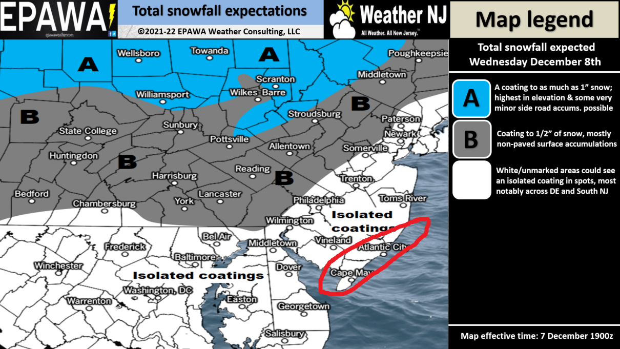
Our snow map yesterday allowed for a coating up to an inch or two statewide. It’s looking like the coating side of the range is most probable per the latest data and observations. And some places might not even see a coating. Areas NW of I-95 have the best chance for stickage. Areas SE of I-95 have the best chance for meltage upon impact, especially on paved surfaces.
The most probable outcome are scattered passing flurries and snow showers. It might make the holiday lights look nice but should have little-to-no impact on travel Wednesday…other than the people who freak out when they see snow falling and do crazy things.
Here’s our updated snow map (below) which mostly speaks to passing flurries and snow showers. I’ve circled an area in extreme SENJ because this area is still being grazed by the N/NW fringe of the precipitation shield on most guidance. Logically, there will be a low passing to our S with a sharp cutoff somewhere either through SNJ or just S/E of NJ. This area will have the warmest surface temperatures but could see the heaviest precipitation in the form of snow or rain. Basically, if there is going to be a wildcard surprise of more snowfall then expected, it would be in the red circled area. But this should be treated as a wildcard and not an expectation.
The reason for the lowered snow expectations is the slow and gradual separation of N and S streams of energy associated with this wave. That and the general weakening of said energy pieces. I’ll be watching for any additional trending on ultra-short range model guidance and live observations this evening/overnight, but we’re likely locked into a conversational snow day tomorrow…not a delayer or closer…likely not even plowable.
After tomorrow, we’re looking at a milder period of above average temperatures through at least Dec 18. It won’t be beach weather…but likely 5-10 degrees above average for December…even warmer for central US. The pattern also appears unfavorable for snow storm development during this period. Some longer range signals are indicating blocking and a looser polar vortex returning around Dec 18 so let’s get to that point and see how things start to evolve for the Christmas period.
In English: Just conversational snowfall tomorrow is likely from passing flurries and snow showers. Some areas could see a coating but that’s about it. A milder, likely snowless, ~10 day period after tomorrow. The pattern should return colder on or just after Dec 18. I’ll see how the radar looks to our W later tonight. Be safe! JC
Download the free Weather NJ mobile app on Apple or Android. It’s the easiest way to never miss Weather NJ content. Our premium services go even further above and beyond at the hyper-local level.
Jonathan Carr (JC) is the founder and sole operator of Weather NJ, New Jersey’s largest independent weather reporting agency. Since 2010, Jonathan has provided weather safety discussion and forecasting services for New Jersey and surrounding areas through the web and social media. Originally branded as Severe NJ Weather (before 2014), Weather NJ is proud to bring you accurate and responsible forecast discussion ahead of high-stakes weather scenarios that impact this great garden state of ours. All Weather. All New Jersey.™ Be safe! JC


LOCAL FORECAST | INTERACTIVE RADAR | LATEST NJ WEATHER ALERTS | WEDDING FORECAST| PRIVACY POLICY
© Copyright 2026 Weather NJ LLC. All Rights Reserved.
Some information that can be found on our website is provided by a private weather station and is not an officially recognized station for weather reporting. Though we always strive to achieve accurate reporting for our own use, it is important that you do NOT depend on the data provided here for any purpose.
