

Cool, Dry and Sunny Weather Expected (Sept 8-10)
Cooler temperatures and clear skies should dominate the weekend. Let’s break it down…
Discussion: Between now and Sunday an upper-level longwave trough will weaken over New Jersey and ultimately lift out to sea. This is the very trough I’ve been watching since Irma formed in late-August. This was the trough that would ultimately have a northward tug on on Irma’s track when nearing the SE US. Because this trough is moving out sooner than later, it has less influence on Irma which results in the track into S FL instead of further up the east coast. Regardless, the trough will be overhead through Sunday before a ridge closes in beneath it heading into Monday. This upper level setup should produce a cooler and crisp scenario for the surface with plenty of sunshine and lower dew points. The entire weekend should feel like October. We might deal with some rainy remnants Tuesday into Wednesday from Irma but this will be very low-impact.
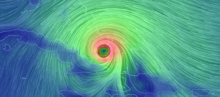
Tropics Update: Irma has weakened slightly, partially for reasons I mentioned in yesterday’s tropical update (Geographic influences of Hispaniola) but mostly because of something called an Eye Wall Replacement Cycle (EWRC). During an EWRC a larger eye forms around the inner eye forcing the inner eye to disappear and expand into the newly-formed outer eye wall. A tropical cyclone typically experiences some weakening during the EWRC but also typically restrengthens afterwards with a larger wind field overall. I anticipate Irma re-strengthening in the near-future (pre-Florida landfall) as models are unanimous in storm pressure drops over the warmest water Irma will see yet. The latest data consensus indicates landfall closer to the center of Florida rather than the coast of Florida. Here’s the latest update from the National Hurricane Center:
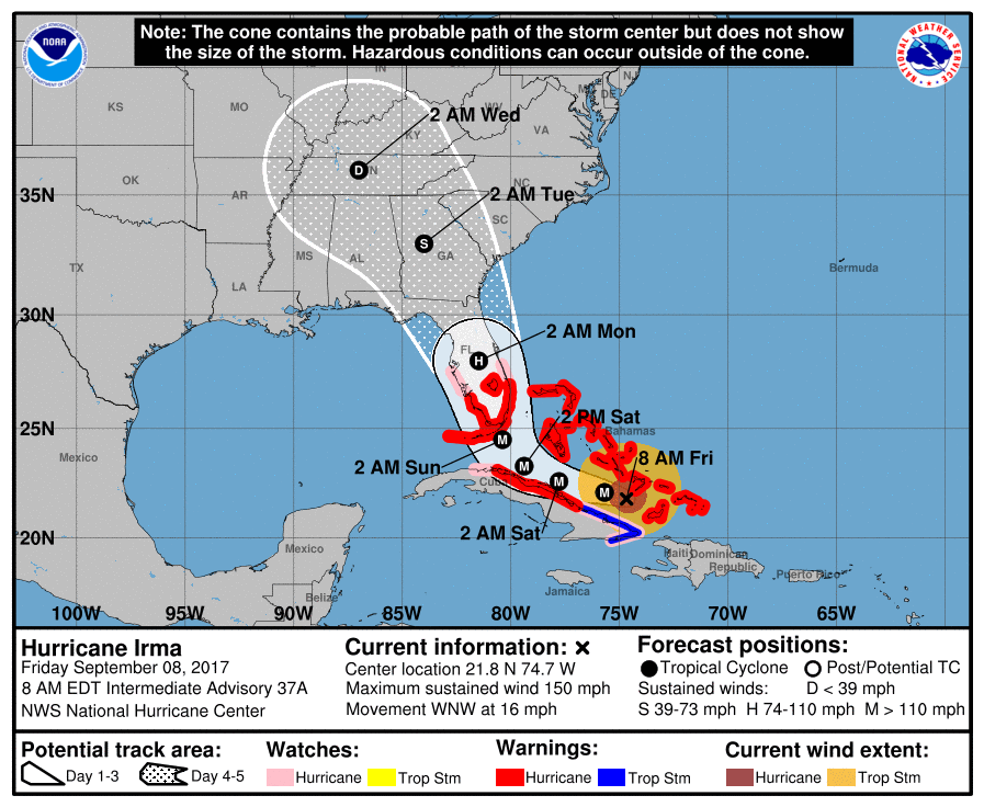
I would still at this point allow either scenario due to upper-level volatility, both of which are very destructive for most of the state. To flesh out the future implications of each:
Landfall along E coast of FL: This would mean a better chance that hurricane conditions make it up to SC. It would mean a better scenario for NW FL (Tampa through the Panhandle). It would mean the worst wind scenario possible for Miami.
Landfall in Keys and track through center of Florida: This would be more destructive for the entire state of FL but would mean a quicker-weakening storm as it moved northward over land. Therefore GA and SC would see much less impact from winds.
Common consequences to both tracks: In either case FL, GA and SC (possibly some of W NC) would likely see a high-impact rain event. The following areas of the FL coast (Naples around through the Keys and up to at least Cape Canaveral) would expect a high-impact storm surge event, possibly as high as 10 feet for the area just N and/or W of the eye wall landfall area. Tropical storm force conditions are expected for S FL as early as Saturday but landfall would likely occur Saturday evening into Sunday morning. Given the large diameter of the storm, impacts will extend well E and W of the eye as it moves through or along the E side of FL.
In either case, New Jersey should expect a low-impact period of rain and wind (looking more like breezy) from Irma when her remnants come through Tuesday into Wednesday. As you can see on the NHC image above, only tropical depression force conditions are expected once Irma gets well over US land.
Friday (Sept 8) high temperatures should reach the low-to-mid 70s for most. NNJ elevations might top out in the upper-60s. Skies should be mostly sunny and pleasant. Winds should be light out of the W. Overnight lows should fall into the 50s for most with NNJ elevations likely dipping into the 40s.
Saturday (Sept 9) high temperatures should reach the low-to-mid 70s for most. NNJ elevations might top out in the upper-60s. Skies should be partly-to-mostly sunny and pleasant. Winds should be light out of the N/NE. Overnight lows should fall into the 50s for most with NNJ elevations likely dipping into the 40s.
Sunday (Sept 10) high temperatures should reach the low-to-mid 70s statewide. Skies should be partly-to-mostly sunny and pleasant. Winds should remain light out of the N/NE. Overnight lows should fall into the 50s for most with NNJ elevations likely dipping into the 40s.
An early look at next week indicates pleasant conditions continuing into the Monday-Tuesday AM period. We could then see some rainy remnants from Irma in the Tuesday PM-Wednesday AM period but I am not expecting anything destructive. Most likely just some rain and breeze. In the meantime our most deepest and sincere thoughts of minimal impact are with all areas in the immediate path of destruction (Bahamas into Florida/SE US) and with those who have already experienced Irma’s destruction. Have a nice weekend and please be safe! JC
Jonathan Carr (JC) is the founder and sole operator of Weather NJ, New Jersey’s largest independent weather reporting agency. Since 2010, Jonathan has provided weather safety discussion and forecasting services for New Jersey and surrounding areas through the web and social media. Originally branded as Severe NJ Weather (before 2014), Weather NJ is proud to bring you accurate and responsible forecast discussion ahead of high-stakes weather scenarios that impact this great garden state of ours. All Weather. All New Jersey.™ Be safe! JC


LOCAL FORECAST | INTERACTIVE RADAR | LATEST NJ WEATHER ALERTS | WEDDING FORECAST| PRIVACY POLICY
© Copyright 2026 Weather NJ LLC. All Rights Reserved.
Some information that can be found on our website is provided by a private weather station and is not an officially recognized station for weather reporting. Though we always strive to achieve accurate reporting for our own use, it is important that you do NOT depend on the data provided here for any purpose.

)