

Dangerous Ice Tonight. Onto Friday.
Discussion: Precipitation should end over the next hour or two as a final slug of moisture moves off Delmarva and scrapes SENJ/ECNJ. Temps are dropping from W to E and rather fast now. Much of NJ is below freezing at the surface except for the coastal span from Sandy Hook to Cape May and about 5-10 miles inland from that. This final burst of precip could set up SENJ/ECNJ in bad shape for sleet/freezing/ice. The rest of the state, below freezing at the surface now, are already encountering ice issues. Temps at the low-mid levels of the atmosphere are also crashing to the coast but not there yet. For this reason, most of ENJ should end with sleet or freezing rain rather than snow. Sleet will likely chill the ground even faster. So, a dangerous icing problem is likely for the rest of this afternoon into this evening. Probably the most dangerous aspect of the entire system. Arctic air will rush back to fill the departing warmer layers by this evening and we will be cold from tonight through the weekend, especially heading into our next storm signal. Anything frozen through this evening will stay ice through this weekend. I recommend treating it if involves travel, walking, etc. Wednesday and Thursday look clear. Cold, but clear.
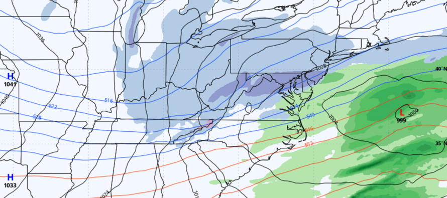
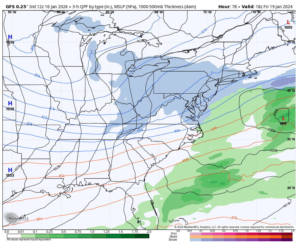
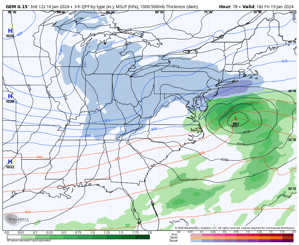
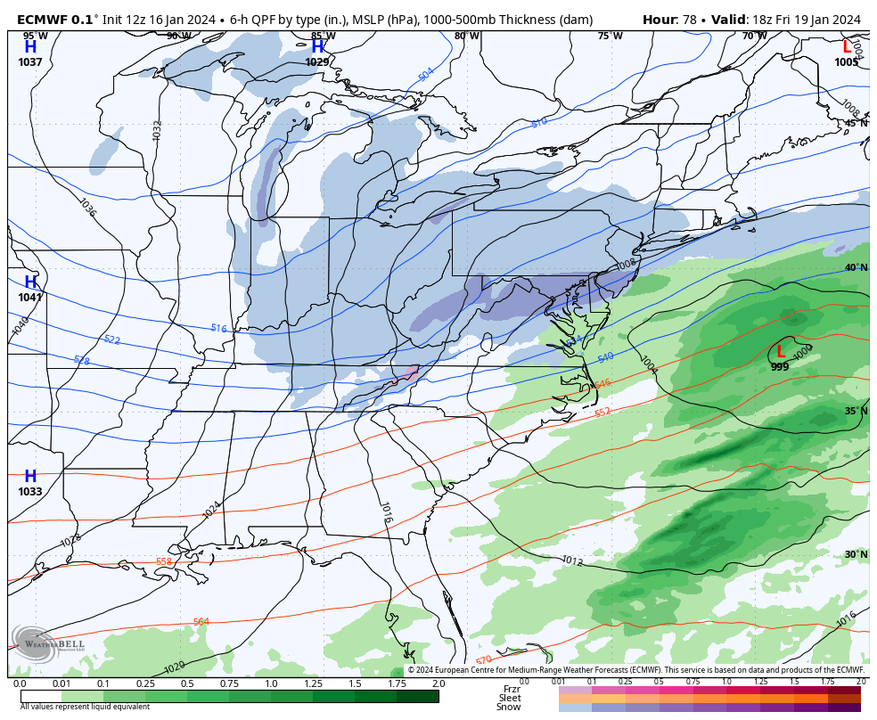
Onto Friday. This is not the blockbuster system that was showing 4-5 days ago in fantasy long-range. And I understand that’s going to disappoint the snow lover, myself included. However it is still a snow signal I am watching. Snow would arrive by late Thursday night and fall through most of Friday morning, wrapping up by noon/early Friday afternoon. At this point, it’s anything from just widespread snow showers producing a coating to an inch or two….to a more concentrated outcome of maybe 4-8 inches max. The Canadian is the most aggressive. The GFS is the least aggressive. The Euro (most recent run) just took steps towards the Canadian and is sort of the middle of the road for now (featured in cover image). Will need another few model suites (tonight’s 00Z and tomorrow’s 12Z) to arrive at a more confident assessment for an initial forecast tomorrow. Here are some of the outputs for the precipitation look and feel.
In English: Any leftover sleet or rain will end in the next few hours. Please use caution as anything wet will freeze as Arctic air moves back in around sundown. We’re then cold and clear tonight through the rest of the weekend. Between late Thursday night and Friday afternoon, anything from a light to significant amount of snow accumulation is possible but likely not a major snowstorm unless things change fast. We then finish a very cold weekend and begin the January thaw the following week. Have a great rest of your Tuesday and please be safe! JC
Premium Services
KABOOM Club offers inside info forecast discussion, your questions answered, and early storm impact maps (ahead of the public). At a buck per month, it’s an extremely feasible way to show support.
My Pocket Meteorologist (MPM), in partnership with EPAWA Weather Consulting, offers professional/commercial interests, whose businesses depend on outdoor weather conditions (snow plowing, landscaping, construction, etc.), with hyper-local text message alerts/forecasts and access to the MPM premium forum—the most comprehensive and technical forecast discussion available for PA and NJ.
Get your KABOOM Inside Out pajamas and more at the KABOOM shop!
Jonathan Carr (JC) is the founder and sole operator of Weather NJ, New Jersey’s largest independent weather reporting agency. Since 2010, Jonathan has provided weather safety discussion and forecasting services for New Jersey and surrounding areas through the web and social media. Originally branded as Severe NJ Weather (before 2014), Weather NJ is proud to bring you accurate and responsible forecast discussion ahead of high-stakes weather scenarios that impact this great garden state of ours. All Weather. All New Jersey.™ Be safe! JC


LOCAL FORECAST | INTERACTIVE RADAR | LATEST NJ WEATHER ALERTS | WEDDING FORECAST| PRIVACY POLICY
© Copyright 2026 Weather NJ LLC. All Rights Reserved.
Some information that can be found on our website is provided by a private weather station and is not an officially recognized station for weather reporting. Though we always strive to achieve accurate reporting for our own use, it is important that you do NOT depend on the data provided here for any purpose.
