

Dangerous Wind Storm Developing
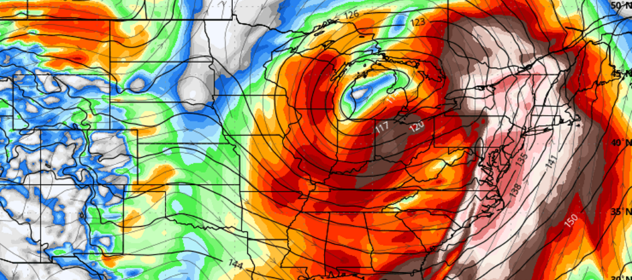
Discussion: This is a very serious weather article with regard to public safety. I don’t like to hype storms but this deserves some hype to ensure maximum situational awareness. I know that this time of year, many are looking for snow. This developing windstorm for tomorrow (Tuesday) into Wednesday morning will not be that. Instead, we’re looking at an incredibly large mid-latitude cyclone with its center of circulation tracking into the Great Lakes. This will likely produce a blizzard for the Great Lakes area, tornadoes for the SC and SE US, but will impact New Jersey in the form of rain and wind. But not just run-of-mill rain and wind.
While much of the lower 2/3 of NJ were missed by the recent snowstorm, a lot of snow did fall across NWNJ, the Poconos, Catskills, and much of interior New England elevations. Most readings were 12-18 inches of snow which has likely compacted some since. The approaching mild rainfall will melt most of this elevated snowpack which will then drain down waterfalls and streams along with the rainfall itself. Basically, we will have a crapload of liquid coming down the Appalachian Mountains into the coastal plain. In addition, a high wind event is heavily modeled during the rainfall. So again, not just a run-of-mil rain and wind event for NJ. This one could really sting. Let’s break the hazards and elements down:
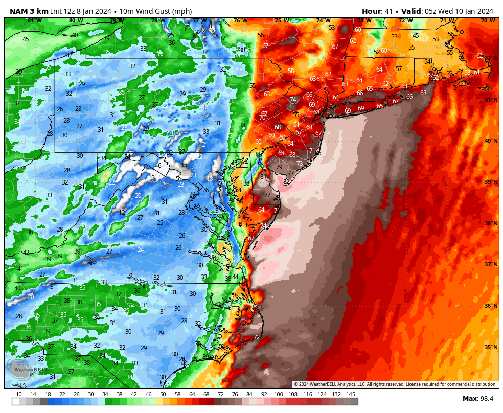
Wind – In most cases, winds are highest along the coast then step down significantly away from the ocean. However, in this case, the flow aloft is aligned from S to N at all tropospheric levels. The 850mb S jet specifically is going to be screaming. It won’t take much convection or precipitation-driven downdrafts to bring some of the screaming jet to the surface. For that reason, the entire state of NJ should expect high wind values, not just the immediate coasts. Perhaps NNJ sees slightly less peak wind gust values than SNJ but there shouldn’t be a great difference. Wind gusts of 60-70mph are not off the table. Most should at least get into the 40-60mph range. If anyone is going to exceed 70mph for wind gusts, it would likely be coastal SNJ along larger part of Delaware Bay and around Cape May up through LBI and Monmouth County beaches. You will know when the cold front is through because winds will transition from “screaming out of the S/SW” to “just gusty” out of the W/NW. Power outages are extremely likely from either falling branches onto power wires and/or falling trees due to rain-saturated soil. Here are the latest modeled wind gusts off the high-resolution NAM. This period is late Tuesday night approaching midnight:
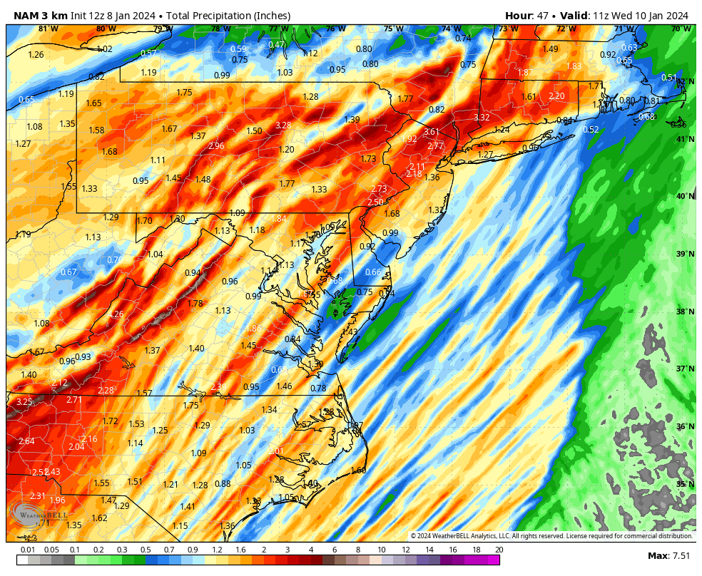
Rain – A safe bet for total storm rainfall is between 1-2 inches. However, 2-4 inches of rainfall are not off the table. Currently NNJ is more favored for the 2-4 range while SNJ is more favored for the 1–2-inch range. In either case, it’s a lot of water to fall in 12 hours which will combine with the melting snowpack in elevations. Flash flooding is possible under the heavier rain bands which will set up randomly. Rivers, lakes, and streams will be up from normal immediately however the strongest flooding potential will be slightly delayed when main rivers, like the Delaware, consolidate the drainage. The area where the Delaware River becomes the Delaware Bay could get high on Wednesday. We also have to consider the compacted/partially melted snow clogging storm drains in the higher elevations. Last, but probably not least, wind-related power outages could render sump pumps useless. You see now how a lot could go wrong! Here are the latest modeled rainfall totals from the high-resolution NAM:
Snow – There is very little to say about snow with this system. The highest NWNJ elevations (High Point Monument area) could briefly start as snow Tuesday like parts of NEPA. But little to no accumulation is expected and any snow should quickly go over to rain with warm air advection like rest of NJ.
Coastal flooding – The setup for saltwater flooding along the Jersey coast is not as dire as the freshwater threat away from the ocean. Yes we might see some elevated tides due to the rainfall and the near-New moon phase. But the actual peak surge period should time with a lower part of the tidal cycle. With all of that considered, there is still the chance for minor coastal flooding…with maybe a single-digit chance for moderate. But I think the flooding headline will be away from the ocean on this one. The worst tidal gauge data is coming from the Reedy Point, DE sensor located where Delaware River opens to Delaware Bay.
Timing – Rain: First drops of rain should arrive around noon Tuesday. Rain should fall on and off, through Tuesday afternoon becoming moderate through about 10pm. Rainfall then becomes heavy 10pm to 3am (just ahead of cold front) and shuts off quickly behind the frontal passage (from 3am-forward). Wind: We’re tranquil tonight (Monday) and overnight into Tuesday morning. Tranquil becomes breezy (gusts to 25mph) by late Tuesday morning. Breezy becomes gusty by Tuesday afternoon (gusts to 40mph). Gusty becomes damaging by Tuesday night (prior to midnight – gusts to 60mph inland). 70+ possible for Delaware Bay, SENJ/ECNJ coasts, or possibly along the immediate warm sector miles ahead of front. The worst winds should end once the cold front passes through (by 3am). You will know when the front is through as raging S/SW winds switch to just gusty W/NW or W winds (25-35mph). These moderate W/NW winds should then persist through much of Wednesday as conditions improve early.
The Future – I am still watching another Great Lakes cutter for this weekend as well as a possible snowstorm for the January 16-17 period. I am still watching for an Arctic chill down from about Jan 15 to at least Jan 24. This will impact W US much stronger than E US but we are all on the hook to have some Arctic airmass available. For now we need to get through one system at a time though.
In English: A nasty and dangerous windstorm is developing. The cover image above represents 850mb winds to show how big it will be. You’ll probably see the satellite signature from this one studies and easily remembered like March 1993 or even Sandy. You might hear news of a Great Lakes blizzard and tornadoes in the south. This very same system will bring unwanted heavy rainfall and dangerous/gusty winds to New Jersey between Tuesday afternoon and early Wednesday morning. There are a lot of hazards in play: power outages, freshwater and saltwater flooding from heavy rainfall and storm surge. Now add in the fact that power outages might render sump pumps disabled. Now also consider that heavy snowpack in the elevations will melt and slide down mountain with inches of rainfall. It’s not going to be pretty folks. I would much rather deal with a large snowstorm. This is different though. This is simply not as fun and much more dangerous. I recommend securing pets, small human beings, and any outdoor items that are loose as well as readying any power backup systems you might have. The worst of the wind will be from late Tuesday night through early Wednesday AM when a powerful cold front pushes through. The worst of the freshwater flooding will likely be delayed until later Wednesday when all the water can collect and drain into Delaware River or other main bodies of flowing water. Buckle up Jersey and be safe! JC
Premium Services
KABOOM Club offers inside info forecast discussion, your questions answered, and early storm impact maps (ahead of the public). At a buck per month, it’s an extremely feasible way to show support.
My Pocket Meteorologist (MPM), in partnership with EPAWA Weather Consulting, offers professional/commercial interests, whose businesses depend on outdoor weather conditions (snow plowing, landscaping, construction, etc.), with hyper-local text message alerts/forecasts and access to the MPM premium forum—the most comprehensive and technical forecast discussion available for PA and NJ.
Get your KABOOM Inside Out pajamas and more at the KABOOM shop!
Jonathan Carr (JC) is the founder and sole operator of Weather NJ, New Jersey’s largest independent weather reporting agency. Since 2010, Jonathan has provided weather safety discussion and forecasting services for New Jersey and surrounding areas through the web and social media. Originally branded as Severe NJ Weather (before 2014), Weather NJ is proud to bring you accurate and responsible forecast discussion ahead of high-stakes weather scenarios that impact this great garden state of ours. All Weather. All New Jersey.™ Be safe! JC


LOCAL FORECAST | INTERACTIVE RADAR | LATEST NJ WEATHER ALERTS | WEDDING FORECAST| PRIVACY POLICY
© Copyright 2026 Weather NJ LLC. All Rights Reserved.
Some information that can be found on our website is provided by a private weather station and is not an officially recognized station for weather reporting. Though we always strive to achieve accurate reporting for our own use, it is important that you do NOT depend on the data provided here for any purpose.
