

Dec 1: Coastal Snow Storm Incoming
Discussion: Phase 1 is about complete. The division between wintry and non-wintry precip went about as expected (somewhere near/along I-95). The wintry area verified colder than expected however. Didn’t think I’d see it snowing that hard in Giants Stadium and the sleet/freezing rain reports are numerous. We should keep this in mind with the next two phases. The snow/ice/rain line is advancing slowly N with the warm front. It should make it to somewhere near I-80. No surprises SE of I-95. Just cold rain so far today.
Phase 2 now begins as the primary surface low (currently over E Great Lakes) transfers to a secondary coastal surface low somewhere off SENJ. I’m already seeing the greatest pressure drops over E Virginia. That area of dropping pressure should rotate cyclonically around to just off SENJ between now and later overnight. Then the secondary coastal will close off and trigger the cold injection via N/NE flow. That will complete the second phase synoptically. At the surface it means that areas N of I-80 are on the hook to remain wintry overnight tonight. Areas S of I-80 will likely remain rain this evening through tomorrow morning.
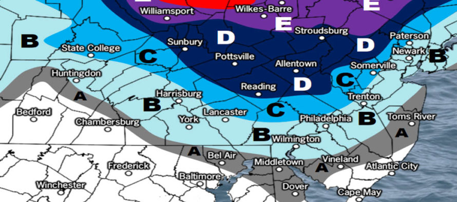
Phase 3 will then begin sometime tomorrow morning. With a closed off surface low somewhere off SENJ winds will be out of the N/NE for all of NJ. Most precipitation will change from whatever it is to snow from N to S. If it’s already snow that means you’re probably somewhere N of I-78. The coastal surface low will interact with the Upper-Level Low (ULL) that drove the primary surface low into the lakes. That ULL is also moving W to E. The interaction between the coastal surface and ULL should form an axis of heavy precipitation extending from E PA through NNJ/CNJ and into New England. This should be the Cold Conveyor Belt (CCB) that will provide the cold and moisture for back-end snowfall. Frontogenic forcing levels should be off the charts under this area but it is very hard to pinpoint who exactly will get it. Mesoscale banding means that localized over-performance equalizes with localized under-performance. The intense lifting that produces the precipitation naturally counteracts with adjacent sinking dry air. For that reason we have the caveat of “locally higher” listed for each area in the snow map legend. Our map is the most reasonable widespread evidence-based prediction. But we recognize that with such strong upper-level dynamics someone could get nailed while their neighbors get shorted. I’d say the I-95 corridor and areas just NW have the largest bust potential in that aspect. We know that NNJ (especially NWNJ) is favored for the jackpot but does CNJ/Philly see it too? Do Monmouth/Ocean/Burlington Counties end with plowable accumulations instead of trace/light accumulations? Does only NWNJ see snow accumulations due to a rogue warm layer on the coastal plain? These are the wildcards we’re dealing with. But for now here is our final conservative call for tomorrow heading into live observations this evening.
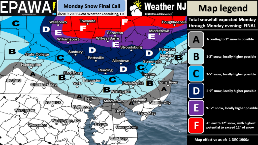
Click here to view full-resolution snow map!
If we see something that warrants changes tomorrow morning we’ll update accordingly. Once this system pulls away completely (by Tuesday morning) it should set the stage for N flow (cold and dry) through most of next week.
In English: Snow and ice should change to rain up to about I-80 (maybe slightly N of that) overnight tonight. That line of freezing should then crash southward tomorrow morning and change most areas over to snow. Periods of snow should then accumulate from tomorrow morning through tomorrow night possibly into early Tuesday AM hours. After that we look cold and dry through next week. This storm looks very disruptive wintry-wise for NNJ and some parts of CNJ. It has already done a job on NNJ today. SNJ and most of CNJ will remain rainy overnight until the changeover tomorrow. I doubt anyone in extreme SENJ (Cape May, Atlantic, S Ocean) will see much accumulation but you could end with robust snow showers. For areas just SE of I-95, and points N/W from there, it could be quite disruptive on Monday especially for the rush hour commute. Our above snow map is reasonable based on data evidence but conservative with respect to the potential if the mesoscale banding kicks in. If you’re looking for exactly what’s going to happen you’ve come to the wrong place and likely no one will ever make you happy. If you want the probable range of possibilities and how to adjust safety awareness and actionable decisions accordingly…then welcome to Weather NJ. Zones B, C and parts of A (Monmouth, Ocean and Burlington) could easily bust higher. We just don’t have enough evidence to support the gut suspicion as a firm forecast. Best to be ready in case. Zones D and E remain in a KABOOM WATCH for now. Be safe! JC
Download the new free Weather NJ mobile app on Apple and/or Android. It’s the easiest way to never miss Weather NJ content. Our premium services go even further above and beyond at the hyper-local level. Looking for industrial-caliber long-range forecasting data that I personally recommend? Check out WeatherTrends360! Visit the Weather NJ Kaboom Shop for hoodies, tees and infant onesies.
Jonathan Carr (JC) is the founder and sole operator of Weather NJ, New Jersey’s largest independent weather reporting agency. Since 2010, Jonathan has provided weather safety discussion and forecasting services for New Jersey and surrounding areas through the web and social media. Originally branded as Severe NJ Weather (before 2014), Weather NJ is proud to bring you accurate and responsible forecast discussion ahead of high-stakes weather scenarios that impact this great garden state of ours. All Weather. All New Jersey.™ Be safe! JC


LOCAL FORECAST | INTERACTIVE RADAR | LATEST NJ WEATHER ALERTS | WEDDING FORECAST| PRIVACY POLICY
© Copyright 2026 Weather NJ LLC. All Rights Reserved.
Some information that can be found on our website is provided by a private weather station and is not an officially recognized station for weather reporting. Though we always strive to achieve accurate reporting for our own use, it is important that you do NOT depend on the data provided here for any purpose.
