

Dec 10: Snow Changeover Approaching
Discussion: Temperatures spiked very mild today as expected. They will drop between now and overnight hours which should change the precipitation type from rain to snow from NW to SE by morning.
We have high pressure pushing the cold in from our NW primarily at the 700-925mb layers. That’s between about 2,500 and 10,000 feet above sea level. The surface layer (where we stand) will struggle to dip below freezing by the time the precipitation ends tomorrow. Only the NNJ elevations (N of I-80/NW of I-287) should dip to near or slightly-below freezing during the precipitation window.
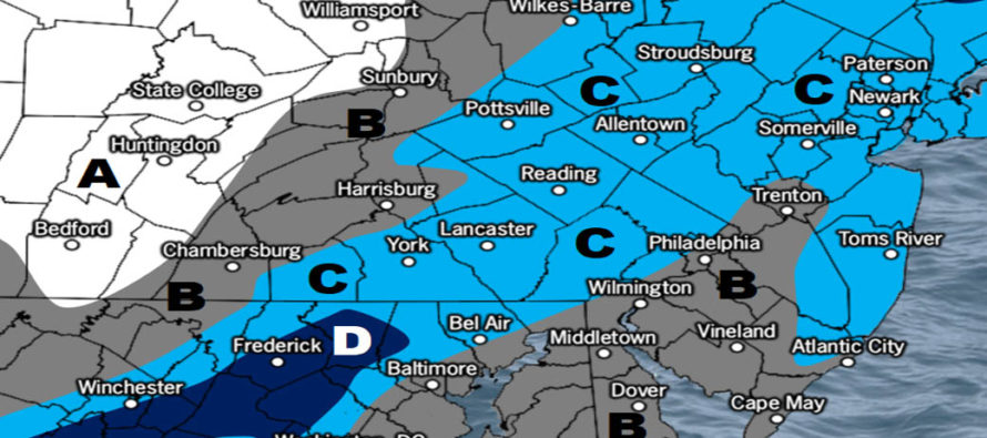
With that said, NWNJ (N of I-80/NW of I-287) has the best chance to see accumulating snowfall. All other lower NJ elevations will likely struggle to achieve stickage especially on the roads. Our map indicates how much snow will fall out of the sky not how much will stack on the roads. Traditional wildcards are at play. Heavy snowfall under meso banding could produce temporary periods of stickage even in SNJ and even on roads (slushy). This would be more so for side streets and minor roadways not major roadways. However meso banding should be isolated, localized and only detectable in realtime. Most areas should only see snow accumulate on natural/grassy surfaces with roads mainly wet. Conversational white rain.
It’s not really a big deal of an event but it should time poorly with tomorrow morning’s rush hour commute. I’d allow for a little more travel time if it was me. We all know that simply the sign of snowflakes, regardless of accumulation, can lead to poor driving behavior. Here’s our updated snow map for tonight into tomorrow:
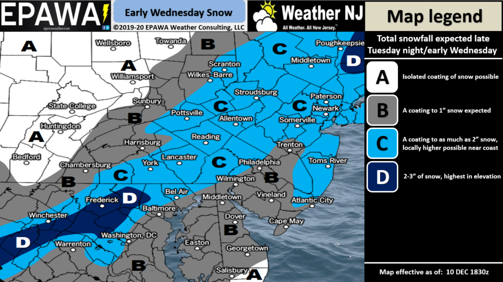
Ckick here to view full-resolution snow map!
In English: Temperatures will drop overnight and rain will change to snow by the morning rush hour commute. Most of NJ will be too warm at the surface for snow to accumulate on roadways. Natural surfaces have a better chance for stickage in these areas. Some of NJ (N of I-80/NW of I-287) will likely drop to near or below-freezing even at the surface and therefore could see a few inches stack up even on paved surfaces. Overall not a big deal but please use caution and allow a little extra travel time tomorrow morning. Be safe! JC
Download the new free Weather NJ mobile app on Apple and/or Android. It’s the easiest way to never miss Weather NJ content. Our premium services go even further above and beyond at the hyper-local level. Looking for industrial-caliber long-range forecasting data that I personally recommend? Check out WeatherTrends360! Visit the Weather NJ Kaboom Shop for hoodies, tees and infant onesies.
Jonathan Carr (JC) is the founder and sole operator of Weather NJ, New Jersey’s largest independent weather reporting agency. Since 2010, Jonathan has provided weather safety discussion and forecasting services for New Jersey and surrounding areas through the web and social media. Originally branded as Severe NJ Weather (before 2014), Weather NJ is proud to bring you accurate and responsible forecast discussion ahead of high-stakes weather scenarios that impact this great garden state of ours. All Weather. All New Jersey.™ Be safe! JC


LOCAL FORECAST | INTERACTIVE RADAR | LATEST NJ WEATHER ALERTS | WEDDING FORECAST| PRIVACY POLICY
© Copyright 2026 Weather NJ LLC. All Rights Reserved.
Some information that can be found on our website is provided by a private weather station and is not an officially recognized station for weather reporting. Though we always strive to achieve accurate reporting for our own use, it is important that you do NOT depend on the data provided here for any purpose.
