

Dec 10: Winter is Coming
Discussion: I wanted to provide a longer-range outlook today after seeing a few things.
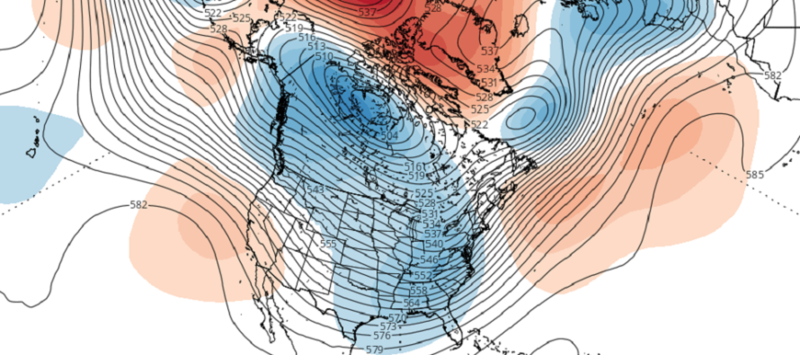
The modeled teleconnections, on the Euro Ensembles, are indicating a much stronger -AO/-NAO pattern setting in. The values take a noticeable dive in the Dec 15-18 period and stay that way for the rest of the guidance period (into Christmas). This means the coldest air of the N Hemisphere would be allowed to spill southward into the mid-latitudes. It also means that a block would establish near Greenland that would hold periods of troughing over the E US—further locking in the cold needed for NJ to see a snowstorm. This allows low pressure systems to take their time, as they encounter the block, and carve through our region in more of a meridional pattern rather than flat and progressive.
The PNA is another teleconnection I follow closely and is indicating slightly positive values between Dec 18-23. This would mean ridging in the W US which further amplifies the E US troughing downstream. It is important to deduce currently that the data suggests a favorable pattern for colder E US cyclogeneses development however does not guarantee a specific surface scenario outcome. That’s for the mid-to-long range forecasting period to pick up and track.
Another piece of data coming out of the Euro is a suggested Polar Vortex (PV) split from Dec 14-ish and forward. The data suggests the coldest lobe of the stratospheric vortex parking over central or eastern Canada. This would produce much colder conditions for NJ and the Mid-Atlantic US in general.
Now let’s consider the next two modeled surface disturbances in the near future. Monday (Dec 14) and then next Wednesday-Thursday (Dec 16-17). Monday looks like a flatter wave that could produce a mix or light snow at best across at least parts of SNJ. The surface profile looks a little warm for stickage. This system will be sliding in at the tail end of the milder period occurring this weekend. Wednesday-Thursday then looks like something bigger and colder but we need to see more consistency before sounding any alarms. Either way, favorable tellies and under an invading PV. For these reasons, I will be watching both systems and will report accordingly.
If the Euro stratospheric guidance and teleconnection data holds and verifies, then Arctic outbreaks of temps would likely be on the table into Christmas. The two systems next week will then be at the forefront of major pattern change. I’ve seen far worse setups for White Christmases.
In English: Seeing some signs of a colder possibly snowy period coming up (like from Monday Dec 14 out until Christmas). Watching two systems, one early next week and one later in the week. Both could bring snow to the region but Monday’s system a bit warm at the lower levels for stickage. Might be dealing with more of a rain/snow mix. The later week system has colder and snowier potential. I’ll take a track seriously or don’t track seriously stance on the Monday system starting tomorrow. Otherwise the weekend looks mild and wet at times. I’ll cover the latest on the Monday and later system in tomorrow’s more detailed weekend outlook. But yeah, it looks like winter is coming folks. Be safe! JC
Download the free Weather NJ mobile app on Apple or Android. It’s the easiest way to never miss Weather NJ content. Our premium services go even further above and beyond at the hyper-local level. Get your merch on at the KABOOM shop in time for the holidays.
Jonathan Carr (JC) is the founder and sole operator of Weather NJ, New Jersey’s largest independent weather reporting agency. Since 2010, Jonathan has provided weather safety discussion and forecasting services for New Jersey and surrounding areas through the web and social media. Originally branded as Severe NJ Weather (before 2014), Weather NJ is proud to bring you accurate and responsible forecast discussion ahead of high-stakes weather scenarios that impact this great garden state of ours. All Weather. All New Jersey.™ Be safe! JC


LOCAL FORECAST | INTERACTIVE RADAR | LATEST NJ WEATHER ALERTS | WEDDING FORECAST| PRIVACY POLICY
© Copyright 2026 Weather NJ LLC. All Rights Reserved.
Some information that can be found on our website is provided by a private weather station and is not an officially recognized station for weather reporting. Though we always strive to achieve accurate reporting for our own use, it is important that you do NOT depend on the data provided here for any purpose.
