

Dec 12: Light Snow Approaching

Discussion: Trends in the last 24 hours indicate a slightly northern track in the upper-level low and surface moisture beneath as well as earlier timing. The upper-level low looks to pass from W to E over the NY State/PA border and ultimately out into the Atlantic Ocean over Cape Cod. This should translate to precipitation for I-195 and points N from there. NNJ still looks most-favored for wintry precipitation with CNJ still favored for a battleground snow/rain line. SNJ is most-favored for rain with whatever precipitation makes it that far S. Since this is a moisture-starved light event I wouldn’t expect much of anything S of I-195. And while parts of CNJ could start out as wintry type precipitation, I would expect snow to change to rain from S to N. We have high pressure that will also be departing into the Atlantic Ocean and the further away that gets from the east coast, the more wind direction will rock from E to S. While flow is E (start of light event) the ocean will damper most snow chances along and SE of I-95/NJTP. Once the flow switches to S the snow/rain line should advance northward as the approaching weekend rain storm’s warm sector gets involved. Extreme NNJ will be the last part of NJ to see precipitation in its coldest form hence being most-favored.
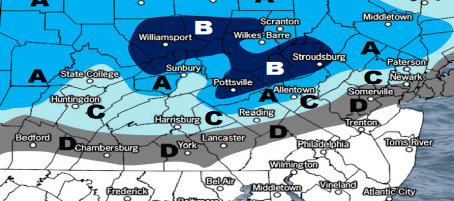
The timing trend has moved up in time. Yesterday this was looking like a Thursday afternoon-evening event. Live observations and the latest data now indicate it will be more of a Thursday morning-afternoon event. With that said the AM rush hour could be hairy for NNJ and the parts of CNJ that start out with wintry precipitation. THIS IS NOT A MAJOR SNOW EVENT however IT DOES NOT TAKE MUCH wintry precipitation to slick untreated roads up. I hope NNJ/northern CNJ utilities are salting tonight. The following snow map represents our thoughts heading into this light NNJ/northern CNJ wintry system:
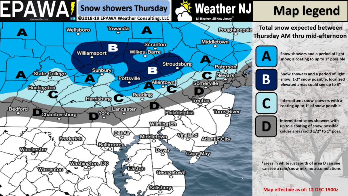
Click here to view full resolution snow map!
In English: I hope you’re enjoying the new free Weather NJ mobile app on Apple and Android. Light snow is on the way for NNJ and northern CNJ to start tomorrow morning out. My best guess on timing: Snow arrives first in NWNJ around 5am and spreads across NNJ /northern CNJ into NENJ by 7am. The snow/rain line should start NE of I-95/NJTP but S of I-78 and slowly advance northward from 7am through early afternoon hours. The above map states our expected amounts. It should be a light event but still possibly hazardous for UNTREATED NNJ/northern CNJ roads. The warmer weekend rainstorm is still expected to follow for Saturday into Sunday. I’ll cover that more tomorrow night in the weekend outlook. Everyone have a great night and please be safe! JC
Jonathan Carr (JC) is the founder and sole operator of Weather NJ, New Jersey’s largest independent weather reporting agency. Since 2010, Jonathan has provided weather safety discussion and forecasting services for New Jersey and surrounding areas through the web and social media. Originally branded as Severe NJ Weather (before 2014), Weather NJ is proud to bring you accurate and responsible forecast discussion ahead of high-stakes weather scenarios that impact this great garden state of ours. All Weather. All New Jersey.™ Be safe! JC


LOCAL FORECAST | INTERACTIVE RADAR | LATEST NJ WEATHER ALERTS | WEDDING FORECAST| PRIVACY POLICY
© Copyright 2025 Weather NJ LLC. All Rights Reserved.
Some information that can be found on our website is provided by a private weather station and is not an officially recognized station for weather reporting. Though we always strive to achieve accurate reporting for our own use, it is important that you do NOT depend on the data provided here for any purpose.
