

Dec 13: More Snow Expected Overnight
Click here to see full resolution snow map!
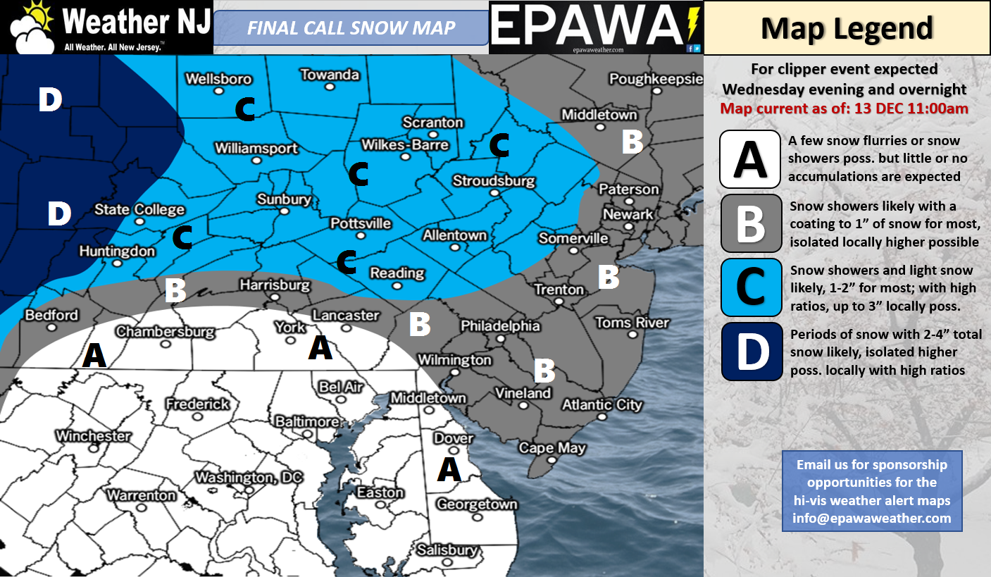
Map Notes: Please see below.
Area A could still see some coatings in that area, especially for the southern PA and northern DE counties. Some model disagreement for those areas, but most give very little to those locations. It is possible extreme SNJ (All of Cape May County and the southern halves of Atlantic + Cumberland Counties) could go this way. Our best model and live obs analysis however pushed us to go “Area B” for all of SNJ.
Area B for most is a coating to 1″ but some areas could see up to 2″ with a combination of higher ratios and a hyper-local rogue band before energy is handed off to the coast. This would be more likely to happen in central PA near the Harrisburg area.
Area C lists 1-2″ with locally higher amounts to 3″, but the highest likelihood to see “locally higher” than 2″ will favor PA locations over NJ locations with ratios and prior to the coastal transfer.
Area D is generally 2-4″ but localized 5-6″ amounts are not out of the question with ratios considered. This area does not concern NJ and is more for far-west coverage region interests.
Discussion: 250mb winds have relaxed over NJ as we fell inside an Arctic trough (reinforced by a lobe of the tropospheric polar vortex) over the last 24 hours. I’m sure you’ve felt it by now. These upper-level winds should increase again over NJ as this disturbance of interest transfers from W PA to the ocean late tonight through tomorrow morning. This ~W to E 250mb jet streak should both enhance the dynamics below and aid in the transfer. 500mb height anomaly analysis indicates that the upper-levels have bottomed out with cold. The lowest area of 500mb heights is moving away to our NE however the entire region will stay below-average through most of this week. The 500mb shortwave and associated vorticity should swing through NJ in this same general time period (tonight through tomorrow morning) as 500mb height anomalies are held down. At the surface, NJ should see most precipitation while the energy is still in-tact over W PA. Once the transfer occurs there will likely be a dry slot over NJ that the precipitation shield never recovers from. With that said, most snow should occur between late tonight and early tomorrow morning. Given how cold the setup is going into this light event, there’s a much better chance of stickage (including roads). This also means that snow rations are expected to be higher (in the 12:1 to 15:1 – inches of snow to inches of liquid – range). It’s the powdery stuff that you can sweep off your porch with a broom in most cases. With that said, visibility can become very limited during heavier bursts of fine powdery snow.
The disturbance I have been watching for Friday-Saturday should track a little too far out to sea to impact NJ. I’m seeing a break in the cold between Dec 18-20 and then again on Dec 22-23 before the cold pattern reloads once again for the Christmas Eve-Christmas Day period. Let’s not get too ahead of ourselves re: a White Christmas. Yes there are some super long-range indications of a disturbance but at this point the colder temperature reload has higher confidence than any surface precipitation chances.
In English: A light snow event is expected across New Jersey tonight through tomorrow morning. It’s not a big deal as far as inches of accumulation go but it can still be possibly disruptive. Please see the above map and map notes just below. If you click on the link immediately below the snow map, a full resolution map will open in a new tab. It’s a powdery light snow event but two things:
1) Instant stickage on all untreated surfaces. Ground temperatures are expected to range from upper-teens to upper-20s from NNJ to SNJ…unlike the last event where ground temperatures were hovering around freezing/just above.
2) Poor visibility under heavier bursts of snow.
NNJ (especially NWNJ) is favored for this system over SNJ (especially SENJ). It should all wrap up by mid-to-late morning tomorrow, if not by mid-morning. The Friday-Saturday system has trended out to sea. We then see a period of moderation between Dec 18-23 with a small cold shot between (Dec 21-22). We should then reload the colder pattern just in time for the Christmas Eve-Day period. Have a great night, be safe and may the force be with you! JC
For comprehensive and interactive hyper-local analysis that goes way above and beyond the detail of this public forecast, check out our premium services.
Jonathan Carr (JC) is the founder and sole operator of Weather NJ, New Jersey’s largest independent weather reporting agency. Since 2010, Jonathan has provided weather safety discussion and forecasting services for New Jersey and surrounding areas through the web and social media. Originally branded as Severe NJ Weather (before 2014), Weather NJ is proud to bring you accurate and responsible forecast discussion ahead of high-stakes weather scenarios that impact this great garden state of ours. All Weather. All New Jersey.™ Be safe! JC


LOCAL FORECAST | INTERACTIVE RADAR | LATEST NJ WEATHER ALERTS | WEDDING FORECAST| PRIVACY POLICY
© Copyright 2026 Weather NJ LLC. All Rights Reserved.
Some information that can be found on our website is provided by a private weather station and is not an officially recognized station for weather reporting. Though we always strive to achieve accurate reporting for our own use, it is important that you do NOT depend on the data provided here for any purpose.
