

Dec 13: Winter Storm a GO
Discussion: Just to recap a little, we’re in a -AO/-NAO/neutral PNA teleconnection pattern. The PV is moving into central-east Canada. The jet is behaving in more of a meridional manner over the US and therefore shortwave disturbances are being moved along the jets in ways that produce synoptic storm systems at the surface. We have two systems of interest this week.
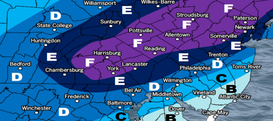
First, the Monday system (tomorrow). We have no changes to our impact map for Monday since yesterday’s release. This is a weak slider with a warm surface heading in. Here’s the map again for reference:
Click here to see full resolution impact map!
Then, we have the Wednesday-Thursday (Dec 16-17) system. Monday’s system will go on to set up a block in the upper levels for this system. Since the coordinates of the block will be near 50N/50W, this is known as a 50/50 block where the back-side upper-level cyclonic flow can stall a surface system from turning N. The Wednesday-Thursday system will be a stronger low. It will want to turn N but the block, along with high pressure over the NE US, will keep it moving E instead.
The low wants to tuck pretty close to the coast. However, there will be very cold air aloft with heavy expected precipitation rates. For this reason, it is difficult to pinpoint the snow/rain line for the first part of the system (with onshore flow). Around or just SE of 95 is where our gut currently is. So for the first half of the system, it’s snow N of 195/W of 95 and likely rain for everyone S and E of such. This should take up most of Wednesday.
Rain is then expected to change over to snow for all areas. This should happen anywhere between Wednesday night and early Thursday AM. The low will be moving away and winds will cyclonically shift to a colder origin for the lower levels. This means all snow from about midnight until daybreak Thursday morning. We still anticipate a plowable snow event for many to the S and E of 95 come Thursday morning. Extreme SENJ (S of AC/East of Cumberland County) are therefore expected to see the least amount of ending snow accumulation since they will change from rain to snow last.
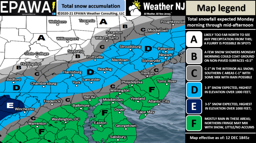
With the above timing, all of NNJ and much of CNJ, are expected to see all snow for the entire event. With the chance of a foot of snow quickly elevating, such areas stand the best chance to KABOOM. We’re not there yet but it IS becoming more likely. Some of the models are actually leaning towards a “Dude where’s my Carr?” scenario for parts of EPA into NNJ. I’m not sure if the system will be moving slow enough for that to happen but it’s not off the table. Here’s our probabilities-based map for the Wednesday-Thursday system. This shows you if you have a greater than 50% chance of seeing the specified amount. Starting tomorrow, our map updates will start listing expected inches:

Click here to see full resolution impact map!
It’s important to mention some wildcard scenarios that could change the forecast or outcome. If the low were to take a slightly more SE track, due to a stronger/colder block, then the heaviest axis of snow could shift from NNJ to CNJ and bring SNJ into bigger snow. Also CNJ and SNJ could verify colder than model guidance due to heavy precipitation rates bringing colder air down to the surface. In the other direction, the snow/rain line could be pushed further NE. In this scenario NWNJ would likely still be in on the heaviest snow. But those along and just NE of the I-95 corridor would see less snow. These wildcards represent the range of possibility. You might see the model guidance trend within that range in these next 72 hours. If that happens and it looks like it makes sense, we’ll adjust accordingly.
In English: A weak wintry system will move through NJ on Monday (please see map above). Light snow accumulations are possible along and NW of the Turnpike, maybe a little more for elevations. Likely rain SE of the Turnpike, maybe some snow mixing in but struggling to accumulate. Wednesday-Thursday is the more important system. Likely all snow for NNJ and much of CNJ. Mixing issues for at least SENJ to start. Our probabilities-based map for this system is also above. Thanks, and everyone please have a great night. Be safe! JC
Download the free Weather NJ mobile app on Apple or Android. It’s the easiest way to never miss Weather NJ content. Our premium services go even further above and beyond at the hyper-local level. Get your merch on at the KABOOM shop in time for the holidays.
Jonathan Carr (JC) is the founder and sole operator of Weather NJ, New Jersey’s largest independent weather reporting agency. Since 2010, Jonathan has provided weather safety discussion and forecasting services for New Jersey and surrounding areas through the web and social media. Originally branded as Severe NJ Weather (before 2014), Weather NJ is proud to bring you accurate and responsible forecast discussion ahead of high-stakes weather scenarios that impact this great garden state of ours. All Weather. All New Jersey.™ Be safe! JC


LOCAL FORECAST | INTERACTIVE RADAR | LATEST NJ WEATHER ALERTS | WEDDING FORECAST| PRIVACY POLICY
© Copyright 2026 Weather NJ LLC. All Rights Reserved.
Some information that can be found on our website is provided by a private weather station and is not an officially recognized station for weather reporting. Though we always strive to achieve accurate reporting for our own use, it is important that you do NOT depend on the data provided here for any purpose.
