

Dec 14: Rainfall Approaching
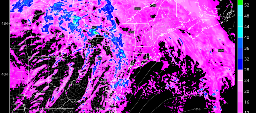
A sub-990mb occluded low is moving through the Great Lakes and will eventually transfer to SE Canada. The attached warm front laid down some light rain overnight and helped contribute to AM fog. Now, we’re in the warm sector of the occluded mid-latitude cyclone which means conditions will stay gloomy and unseasonably warm until the cold front comes through. Rain is expected ahead of the cold front which will push through our region between now and tomorrow morning. I’d say the prime window for rainfall is late afternoon today/early evening through sunrise tomorrow.
Given the dynamics of everything (strong low/frontal passage/etc), rainfall could fall with more of a convective nature rather than widespread. This means bands of heavy rain (alternating on-off) rather than a consistent steady rain. With that said, expect possible breezy conditions with the rain. I wouldn’t rule out a very small chance of embedded t-storms (rolling thunder). We’ll see. Either way, the rainfall is much needed and we’ll clear out for tomorrow.
In English: Today should be gloomy until it rainfall moves in between late afternoon and evening hours. With any luck, it should clear by rush hour tomorrow AM but no promises. Total modeled rainfall is between one-quarter to three-quarters of an inch. Conditions should improve during the day tomorrow. Wash rinse repeat Thursday into Friday. Be safe! JC
Jonathan Carr (JC) is the founder and sole operator of Weather NJ, New Jersey’s largest independent weather reporting agency. Since 2010, Jonathan has provided weather safety discussion and forecasting services for New Jersey and surrounding areas through the web and social media. Originally branded as Severe NJ Weather (before 2014), Weather NJ is proud to bring you accurate and responsible forecast discussion ahead of high-stakes weather scenarios that impact this great garden state of ours. All Weather. All New Jersey.™ Be safe! JC


LOCAL FORECAST | INTERACTIVE RADAR | LATEST NJ WEATHER ALERTS | WEDDING FORECAST| PRIVACY POLICY
© Copyright 2026 Weather NJ LLC. All Rights Reserved.
Some information that can be found on our website is provided by a private weather station and is not an officially recognized station for weather reporting. Though we always strive to achieve accurate reporting for our own use, it is important that you do NOT depend on the data provided here for any purpose.
